Talk:Ming dynasty/Archive 3
| This is an archive of past discussions. Do not edit the contents of this page. If you wish to start a new discussion or revive an old one, please do so on the current talk page. |
| Archive 1 | Archive 2 | Archive 3 |
Map Problem ———Current is a kind of original research
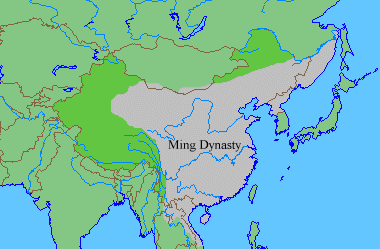
I want to change the map. I want to use [1] Herrmann map from "History and Commercial Atlas of China" to replace current one.
Current map had two problems:
1. The map I used [2] is from a history research publication ("History and Commercial Atlas of China") which is considered as reliable source. The map was published by Harvard University Press. Current map did not offer any publication as the source and it was claimed to creat by a wiki user as own work. Hence, current map is a original research and it was against No original research rule.Use current original research map violated the wiki rule. We cannot submit a map to wiki which was edited by ourselves. Hence, I use the map from scholar publication to substitute it.
2. Then we have some article with reliable source supported Herrmann map. We have article Ming conquest of Manchuria and Manchuria under Ming rule which had sources " Early Ming China: A Political History" published by Stanford University Press and "Perpetual Happiness: The Ming Emperor Yongle" published by University of Washington Press. These supported the Manchuria parts of Herrmann map which is current map missed. Then Fourth Chinese domination of Vietnam supported the Vietnam part of Herrmann map. --Miracle dream (talk) 04:28, 12 April 2018 (UTC)
![[1]](https://commons.wikimedia.org/wiki/File:Map_of_Ming_Chinese_empire_1415.jpg)
- We certainly can use a user-created map, provided it accurately represents the consensus of reliable sources. Indeed for an infobox, a specially-created map without extraneous detail is clearer. In this case, the map closely corresponds to the following maps (minus details):
- Mote, Frederick W.; Twitchett, Denis, eds. (1998). The Cambridge History Of China, Volume 7: The Ming Dynasty, 1368-1644, Part I. ISBN 978-0-521-24332-2. Map 1, p. xxiv.
- Brook, Timothy (2010). The Troubled Empire: China in the Yuan and Ming Dynasties. Harvard University Press. ISBN 978-0-674-04602-3. Map 6, p. 41.
- Wikipedia articles are not reliable sources. You need to investigate reliable sources used by those articles and present the relevant parts of those. In addition, Herrmann's Historical and Commercial Atlas of China (1935) is quite dated. Kanguole 15:31, 12 April 2018 (UTC)
- This is against Wikipedia:No original research#Synthesis of published material. The map is not directly copied from any sources you listed above. A wiki user read two or three source you listed and synthesize these sources to create his own map by his own judgment. This is what we called original research and violated Wikipedia:No original research#Synthesis of published material. Then he decided to remove a publication source map by his own judgment. This is another kind original research. Determine a scholar publication unreliable by wiki user own judgment is another kind of original research. Moreover, it is against Wikipedia:Neutral point of view rule. We cannot delete scholar publication by own bias judgment. The map I used is not edited by me and not synthesized by me, it is directly copied from reliable source. Then I did not use wiki to support my claim. I use " Early Ming China: A Political History" published by Stanford University Press and "Perpetual Happiness: The Ming Emperor Yongle" published by University of Washington Press to support my claim. Miracle dream (talk) 16:10, 12 April 2018 (UTC)
- WP:OI is the relevant part of the NOR policy: Original images created by a Wikipedian are not considered original research, so long as they do not illustrate or introduce unpublished ideas or arguments, the core reason behind the NOR policy. In this case we have a user-created image that faithfully conveys the representation in the two published sources I cited above.
- What text in those two books supports your claim? Kanguole 16:38, 12 April 2018 (UTC)
- The Map itself support my claim. As I said, I did not use map edited by me and it is directly copied from scholar publication. The map was not made by a random user's synthesis but based exactly off this map in a book by Harvard University Press. The current map is synthesized by wiki user. Hence, the question should be what text support the current map. Based on the case, it was not from any scholar publication. Another question is why wiki user can delete a scholar publication source by his own judgment instead of Wikipedia:Neutral point of view. Current case is wiki user use some map which he own edited based on his own reading instead of the map directly copied from scholar publication. Please note WP:OI said "It is not acceptable for an editor to use photo manipulation to distort the facts or position illustrated by an image. Manipulated images should be prominently noted as such. Any manipulated image where the encyclopedic value is materially affected should be posted to Wikipedia:Files for discussion. Images of living persons must not present the subject in a false or disparaging light." Miracle dream (talk) 16:48, 12 April 2018 (UTC)
- I have given specific references that support the current map.
- The text you have quoted about photo manipulation is irrelevant, and you seem to have missed the point of what WP:OI is saying.
- It seems you are no longer claiming sourcing from those two books, but relying solely on Herrmann's altas, which, as I said above, is severely dated. Kanguole 17:14, 12 April 2018 (UTC)
- No, you didn't give anything. You just list two books' name and did not quote any text which cannot be considered as the claim you said "support". It seems you never explain anything about the current map and simply against the map from publication. I am not solely rely on the source but the map is directly copied from the source which is scholar publication. Miracle dream (talk) 16:48, 12 April 2018 (UTC)
- I gave a page and map number in each case. Kanguole 17:34, 12 April 2018 (UTC)
- No, you didn't give anything. You just list two books' name and did not quote any text which cannot be considered as the claim you said "support". It seems you never explain anything about the current map and simply against the map from publication. I am not solely rely on the source but the map is directly copied from the source which is scholar publication. Miracle dream (talk) 16:48, 12 April 2018 (UTC)
- The Map itself support my claim. As I said, I did not use map edited by me and it is directly copied from scholar publication. The map was not made by a random user's synthesis but based exactly off this map in a book by Harvard University Press. The current map is synthesized by wiki user. Hence, the question should be what text support the current map. Based on the case, it was not from any scholar publication. Another question is why wiki user can delete a scholar publication source by his own judgment instead of Wikipedia:Neutral point of view. Current case is wiki user use some map which he own edited based on his own reading instead of the map directly copied from scholar publication. Please note WP:OI said "It is not acceptable for an editor to use photo manipulation to distort the facts or position illustrated by an image. Manipulated images should be prominently noted as such. Any manipulated image where the encyclopedic value is materially affected should be posted to Wikipedia:Files for discussion. Images of living persons must not present the subject in a false or disparaging light." Miracle dream (talk) 16:48, 12 April 2018 (UTC)
- This is against Wikipedia:No original research#Synthesis of published material. The map is not directly copied from any sources you listed above. A wiki user read two or three source you listed and synthesize these sources to create his own map by his own judgment. This is what we called original research and violated Wikipedia:No original research#Synthesis of published material. Then he decided to remove a publication source map by his own judgment. This is another kind original research. Determine a scholar publication unreliable by wiki user own judgment is another kind of original research. Moreover, it is against Wikipedia:Neutral point of view rule. We cannot delete scholar publication by own bias judgment. The map I used is not edited by me and not synthesized by me, it is directly copied from reliable source. Then I did not use wiki to support my claim. I use " Early Ming China: A Political History" published by Stanford University Press and "Perpetual Happiness: The Ming Emperor Yongle" published by University of Washington Press to support my claim. Miracle dream (talk) 16:10, 12 April 2018 (UTC)
Firstly, either map can be used, because both of them are seemingly credible and backed by scholarly sources. The assertion that Herrmann's map is too dated (i.e. published 1905) is a fair argument, but it seems to be backed up by far more recent scholarly sources. For instance, this map from a Saint Martin's University web page and this map from a University of Oregon web page. Therefore, the real question here isn't which map is more accurate or backed by reliable sources; the question we should be asking is what map and particular point in time during the Ming period should its borders be featured in the infobox of the lead section? The current map is okay, showing the stable borders of the late Ming period, but the Yongle map shows how the empire existed virtually at its height of territorial expansion in the early 15th century. Pericles of AthensTalk 17:47, 12 April 2018 (UTC)
- Images on websites are hardly strong sources – the first of those is copied from the Herrmann map, while the second is extremely weak. Kanguole 17:56, 12 April 2018 (UTC)
- Well, that's an opinion you can have, but it doesn't change the fact that these images came from websites created by credible academic institutions, namely Saint Martin's University and the University of Oregon. You make it sound as if they were pulled from a blog or hobbyist site, which is something else entirely. In either case, I don't see anything wrong with using the Yongle map, but there's no real pressing need to change the current map either. Both are decent representations of the borders of the Ming Empire at different points in time. The Yongle borders were rather ephemeral, though, especially in the case of northern Vietnam, which was held for only two decades by Ming forces. Pericles of AthensTalk 18:02, 12 April 2018 (UTC)
- @ PericlesofAthens No, I don't think it's that problem. I think use a map edited by wiki user instead of a map which is directly copied from map is not a wise way. At first, you admit my map is directly copied from scholar publication, right? Then you admit the current map is a wiki user edition based on his reading, right? Even based on Wikipedia:Neutral point of view rule, you should at least keep both. Miracle dream (talk) 16:48, 12 April 2018 (UTC)
- The current map of the late Ming Empire is fine. It's okay to base the map off of two different scholarly sources (in this case Mote, Twitchett, and Brook). I reiterate: the real question we should be asking is why should it be replaced by the Yongle map as far as preference is concerned? On what grounds? There's also nothing stopping you from placing the Yongle map somewhere else in the article aside from the lead section. Pericles of AthensTalk 18:06, 12 April 2018 (UTC)
- As I said, the current map is made by random wiki user based on his understanding of scholar research. If you want to keep this map, based on Wikipedia:Neutral point of view rule, you should at least keep both. Then based on other article like Ottoman Empire and Byzantine Empire infobox, my map is more acceptable. All I try to do is based on wiki rule and other wiki articles. I think it's not wise to create a new standard in this article alone and ignore the standard of almost all other wiki article. Miracle dream (talk) 16:48, 12 April 2018 (UTC)
- Your argument about using the Yongle map is not a bad one, if we're talking about representing the Ming Empire at its zenith and height of territorial expansion under the Yongle Emperor. However, we already have a talk page section for this conversation above. I'm also not sure how you intend on having two different maps in the infobox of the lead section. Firstly, is that even technically possible? And secondly, that sounds like complete overkill. I think both images could be used in the article, and either of them would make decent lead-section images. If you can find space for it in a relevant section, feel free to add the Yongle map to the article, but it seems like there are already too many images cluttered around the section about the Yongle Emperor. Pericles of AthensTalk 18:40, 12 April 2018 (UTC)
- @ PericlesofAthens. It is easy to do this. Now see the article, I made an edition which kept both map. Miracle dream (talk) 19:03, 12 April 2018 (UTC)
- Hmm...having two maps arranged together like that looks somewhat goofy. I'm not sure that I like it, personally, but I don't have any strong objections to it either. Preferably one map should be chosen over the other for the lead section, while one of the two maps can simply be used somewhere else in the body of the article. Pericles of AthensTalk 19:11, 12 April 2018 (UTC)
- @ PericlesofAthens.I wrote the time for each map in infobox. The first is under Yongle Emperor and the second is around 1580. If you want to keep one, then I think the map during Yongle Emperor should be kept and remove the 1580s map. At first, it is the same standard of other wiki article such as Ottoman Empire and Byzantine Empire infobox which all used the map of largest area. Actually, Byzantine Empire only kept the area of the map used in wiki about 4 or 5 years. However, it is still used as the map in infobox. Another reason to choose the Yongle map is that it is a directly copy from a scholar publication and the 1580 map is edited by a random wiki user based on his understanding of scholar publication. Miracle dream (talk) 19:28, 12 April 2018 (UTC)
- I agree that the map should represent the greatest extent of the empire for the sake of consistency.--Alvin Lee 13:20, 25 July 2018 (UTC)
- @ PericlesofAthens.I wrote the time for each map in infobox. The first is under Yongle Emperor and the second is around 1580. If you want to keep one, then I think the map during Yongle Emperor should be kept and remove the 1580s map. At first, it is the same standard of other wiki article such as Ottoman Empire and Byzantine Empire infobox which all used the map of largest area. Actually, Byzantine Empire only kept the area of the map used in wiki about 4 or 5 years. However, it is still used as the map in infobox. Another reason to choose the Yongle map is that it is a directly copy from a scholar publication and the 1580 map is edited by a random wiki user based on his understanding of scholar publication. Miracle dream (talk) 19:28, 12 April 2018 (UTC)
- Hmm...having two maps arranged together like that looks somewhat goofy. I'm not sure that I like it, personally, but I don't have any strong objections to it either. Preferably one map should be chosen over the other for the lead section, while one of the two maps can simply be used somewhere else in the body of the article. Pericles of AthensTalk 19:11, 12 April 2018 (UTC)
- @ PericlesofAthens. It is easy to do this. Now see the article, I made an edition which kept both map. Miracle dream (talk) 19:03, 12 April 2018 (UTC)
- Your argument about using the Yongle map is not a bad one, if we're talking about representing the Ming Empire at its zenith and height of territorial expansion under the Yongle Emperor. However, we already have a talk page section for this conversation above. I'm also not sure how you intend on having two different maps in the infobox of the lead section. Firstly, is that even technically possible? And secondly, that sounds like complete overkill. I think both images could be used in the article, and either of them would make decent lead-section images. If you can find space for it in a relevant section, feel free to add the Yongle map to the article, but it seems like there are already too many images cluttered around the section about the Yongle Emperor. Pericles of AthensTalk 18:40, 12 April 2018 (UTC)
- As I said, the current map is made by random wiki user based on his understanding of scholar research. If you want to keep this map, based on Wikipedia:Neutral point of view rule, you should at least keep both. Then based on other article like Ottoman Empire and Byzantine Empire infobox, my map is more acceptable. All I try to do is based on wiki rule and other wiki articles. I think it's not wise to create a new standard in this article alone and ignore the standard of almost all other wiki article. Miracle dream (talk) 16:48, 12 April 2018 (UTC)
- The current map of the late Ming Empire is fine. It's okay to base the map off of two different scholarly sources (in this case Mote, Twitchett, and Brook). I reiterate: the real question we should be asking is why should it be replaced by the Yongle map as far as preference is concerned? On what grounds? There's also nothing stopping you from placing the Yongle map somewhere else in the article aside from the lead section. Pericles of AthensTalk 18:06, 12 April 2018 (UTC)
Emperor Hongwu and the other four Ming emperors were 100% Buddhist
Buddhism should be 96.5% of the population during the great Ming dynasty. You cannot just list a bunch of different religions like that. Buddhism is more interesting usually and is the most important religion in China. Please note that fact that Emperor Hongwu and the other four Ming emperors were 100% Buddhist, praying to Bhudda and Kuan Yin Posa. Also, the largest proportion of the the Ming dynasty's population are Buddhists, the different children, wives, princes and princesses and the peasants and nobility were 100% Buddhist during the Ming dynasty.
Roman Catholicism is bad and harassing if you are NOT a western person.
During the Ming dynasty, you or the historians should clarify that maybe only 0.0001% (very few, minimal) of the Population were Catholic, or hardly anybody. A teeny bit of the population were whitewashed and disloyal enough to be Catholic.
I have previously respected and praised Emperor Kangxi but now after reading history books about his CRAZY obsession with western religion, Emperor Kangxi is a TRAITOR to China and to the Han people. I like the Qing dynasty buildings and the Qing dynasty imperial clothes for women which are beautiful clothes and for men as well.
In reality, the Jesuits are very disrespectful and rude. The foreign women/prostitues look ugly and are very rude and the Jesuits are WRONG for forcing Chinese nobility and moderate income and poor people to abandon their culture and their valuable Buddhist religion.
Buddhism should be 96.5% of the population. Buddhism is more interesting usually and is the most important religion in China. During the Qing dynasty, this Friar Thomas Pereira should have been executed from forcing and invading China. If Chinese people were to move to western countries back then and started opening Buddhist churches and telling families to THROW away Catholicism, many western people would be against this and very upset and angry. Emperor Kangxi is a waste of a great emperor because Kangxi wrongfully supported foreign invasion in China. Note: If western people want to practice Catholicism, then FINE, not a problem. However, Emperor Kangxi made a BIG MESS by issuing that crazy treaty to bully and manipulate people to be tolerant of Catholicism. Catholicism and the Jesuits are ANNOYING and making trouble with their illegal occupation. Emperor Kangxi was a competent ruler but Kangxi was incompetent because he has NO RESPECT for China. The Manchus/Mongolians have NO RESPECT and are harmful to the Buddhist religion.
During the Qing reign of China, Emperor Hong Taiji was a talented ruler. However, Hong Taiji was a jerk for being against/cursing the Tibetan Buddhism. — Preceding unsigned comment added by 135.0.50.11 (talk) 21:13, 23 August 2018 (UTC)
- Thanks for the bizarre rant and WP:FORUM violation ...
Ming Protectorates
According to this source, Cochin Kingdom was a protectorate of Ming Dynasty. Where would this be added in the page?Manabimasu (talk) 23:00, 6 April 2021 (UTC) I made an edit. here.https://en.wikipedia.org/w/index.php?title=Ming_dynasty&oldid=1016394566Manabimasu (talk) 23:11, 6 April 2021 (UTC)
Rule of Ming in Brahmaputra Valley or Northeast India
Da Gu-la, Xiao Gu-la, Di-ma-sa, Cha-shan, Di-ban, Meng-lun and Ba-jia-ta. http://www.epress.nus.edu.sg/msl/reign/yong-le/year-4-month-6-day-24 Tie-ji-li http://epress.nus.edu.sg/msl/place/tie-ji-li Di-wu-la http://www.epress.nus.edu.sg/msl/place/di-wu-la
Da Gu-la (Chief name: Po-di na-lang) is some kachari ( Kachari kings surname : Narayan) kingdom , Di-ma-sa is Dimasa kingdom (https://www.jstor.org/stable/25189042), Meng-lun (Chief name : Dao Han-ti) is Ahom (King name : Tao Khamti) kingdom and Ba-jia-ta is Bakata, Di-ban is Tipam, Di-wu-la is Ti-pu-ra or some Boroic linguistic kingdom because Di/Ti means water and many places and rivers name begin with Di/Doi in Assam , Tie-ji-li may be Chutia kingdom because Chief Du-le-na-lan = King Durlabh Narayan etc. Ahom Buranjis or Chronicles give History of Ahom kingdom but these chronicles contradict each others and Time for different Kings before 16th century aren't correctly dated.
Can these facts be added in the article ? 2409:4065:E99:FC09:4C4E:C009:CD22:8A15 (talk) 14:29, 10 October 2021 (UTC)
- In reply to your request on my Talk Page: I'm flattered to be asked for advice! I looked at the source for your facts, which is online version of a highly respected and reliable source, Geoff Wade's scholarly translation of the Ming Shilu, the basic annals of the dynasty.
- That is, it is a WP:PRIMARY SOURCE. You deserve credit for finding it, but using a Primary Source is ORIGINAL RESEARCH which is against Wikipedia policy.
- A second thought is that this article should not have this level of detail in any case. See WP:NOT, which explains why. There is not room for every important fact, since that would turn an article into a directory and make it hard for a reader to see the big picture.
- A more valuable contribution would be to look at the article as a whole and see what would be proportionate about Ming rule in Brahmaputra Valley and parallel to treatment of other areas (which is already quite substantial), then find a WP:RELIABLESOURCE in WP:SECONDARYSOURCES. More than a sentence or so would probably be more appropriate and welcome for the "Main article" linked at the head of a section.
- Hope this helps. ch (talk) 17:33, 10 October 2021 (UTC)
- I doubt existence any secondary source with much clarity. Anyway Thank you for the reply. 2409:4065:E89:DE03:A809:4E46:970E:8809 (talk) 01:41, 11 October 2021 (UTC)
orthodoxy
- The Ming dynasty was the last orthodox dynasty of China ruled by the Han people,
What does "orthodox" mean in this context? Perhaps: recognized by a consensus of historians? —Tamfang (talk) 00:09, 15 March 2023 (UTC)
- Probably - or just "imperial"? Best rewritten anyway - it was a really tiny, tiny fraction of the "Han people" who ruled! Johnbod (talk) 00:27, 15 March 2023 (UTC)