Talk:Meesapulimala
| This article is rated Stub-class on Wikipedia's content assessment scale. It is of interest to the following WikiProjects: | ||||||||||||||||||||||||||||||
| ||||||||||||||||||||||||||||||


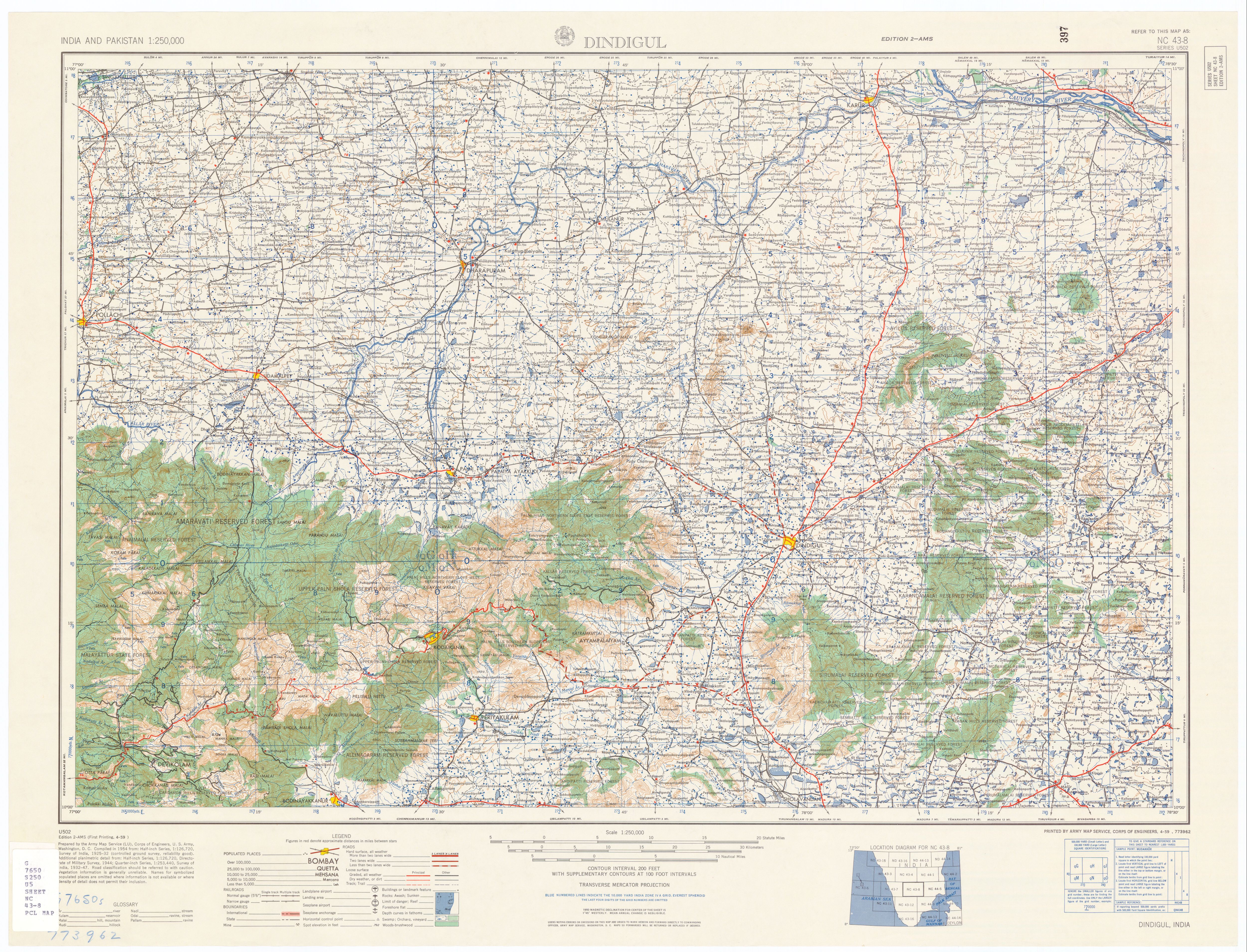
1) Agree that 8661ft on map posted (http://www.lib.utexas.edu/maps/ams/india/nc-43-08.jpg) refers to "Meesapuli Mala", however just north of that marking is a "Manna Malai" with altitude 8724ft (visible on map posted), higher than Meesapuli Mala, which thus cannot be the 2nd highest peak in South India after Annamudi (highest).
2) Messa="mustache", or "whiskers"; Puli="Tiger"; and Malai= Mountain/hill. The name of this Mountain is literally "Whiskers (of the) Tiger Mountain". or Tiger's Whiskers Mountain The name is derived from the appearance of this mountain from the valley south and west of this notable (from that valley) prominence. The higher peak behind it (tentatively Manna Malai, per posted map) is not visible from the valley, or leaves no lasting impression from that viewpoint. Therefore:
3) The peak is misidentified, the actual location is 10deg, 5min, 16sec North, and 77deg, 12min, 16sec East (10.087727N,77.204318E). The peak misidentified is labeled "Manna Malai" in the 1954 US Army map posted at the article. It also appears as only an altitude (2659M), with "Misappuly Malai (2624M)", that is, a name with an altitude (in parenthesis) directly below it, located just South of the (2659M) (in parenthesis) altitude label on a map that I possess that was originally posted at KDHP (Kanan Devan Hills Plantations) Company (P) Ltd. website entitled "Tea Sanctuary Map - big". I am unable to share that map, as it is no longer available on the web, and my copy is probably copy writ. A map currently posted at KDHP website is not as detailed as the one I downloaded from them some years ago. I have asked them to repost the former map.
4) Although this mountain can be thought of as a Kerala Mountain (though it sits on the border with Tamilnadu, with a border monument reportedly located at it's summit), and the predominant language of Kerala is Malayalam, which uses the word "Mala" for mountain, the area it is located in, and thus the local language, is predominantly Tamil, and it would locally be referred to as "Malai", as the posted map does affirm concerning the names of peaks in the neighborhood of this peak.
5) Publicized treks to this Mountain as a destination are increasingly drawing more tourists to it's summit. At least one has reported a higher peak north of the summit they were taken up.
Incorporation of any of the above would make the article more accurate, relevant and interesting.72.251.27.40 (talk) 12:30, 1 January 2015 (UTC)
I trekked both these peaks in December 2015 after I had doubts regarding the claim of Meesapulimala being the second highest peak in the western ghats when there was clearly a taller peak visible to the north as seen from Meesapulimala. My altitude readings were consistent with the observations here. Meesapulimala was 2640 meters and Mannamalai was 2659 meters.
I also found something that resembled a border marker on the ridge connecting Meesapulimala and Kolukkumalai. There was a date written on a rock with another word above it that read RF followed by some number.Siva1511 (talk) 12:23, 27 October 2015 (UTC)
For add some photos at top of this mountain edit
Myself holds some photos of this mountain with me.How can I contribute into this page ? MridulMadhav009 (talk) 06:13, 15 August 2016 (UTC)