Talk:Kalapani territory
| This is the talk page for discussing improvements to the Kalapani territory article. This is not a forum for general discussion of the article's subject. |
Article policies
|
| Find sources: Google (books · news · scholar · free images · WP refs) · FENS · JSTOR · TWL |
| Archives: 1Auto-archiving period: 180 days |
| This article is rated C-class on Wikipedia's content assessment scale. It is of interest to the following WikiProjects: | ||||||||||||||||||||||||||||||||||
| ||||||||||||||||||||||||||||||||||


This article has been mentioned by multiple media organizations:
|
A travel report from 1829
editHere is a travel report from 1829, barely a decade after the Sugauli Treaty, from an anoymous traveller, published in a journal called Gleanings in Science, which I had never heard of before:
- "Account of a Visit to the Bians Pass in the Indo-Gangetic Range beyond the Head of the Kali River", Gleanings in Science, 1: 97–99, 1829 – via biodiversitylibrary.org
13th: ... Here the Kali proper, which is however the smaller of the two, joins the main branch. The latter appears to originate to the westward, the people say at a distance of three days journey, and the ridge from which it springs separates the districts of Dharma and Bians.
So "Kali proper" was the eastern branch, the smaller of the two branches (the other one being obviously the Kuti Yangti).
14th: To the pass Lepu Dhura... is only three hours' journey; marched about half past six, stopping to breakfast at the place called Kalapani, where a stream of clear water about 25 feet wide, but very shallow, issues from the neighbouring rocks, on the left bank of the larger stream.
So "Kalapani" was on the left bank of the Lipu Gad/Kalapani River, and one passed it on the road to Lepu Dhura. There is no mention of Nepal or the Nepalese government. The whole discussion reflects travelling in one and the same country, viz., British Kumaon.
It is a pity that the journal withheld the name of the traveller. But he was certainly resourceful enough to carry a barometer, but didn't know the intricacies of calculating altitude from barometric pressure. So perhaps a scientist of some sort.
He was aware of Colonel Webb, and perhaps carried a copy of his map. If Webb's map had the upside down "Kalee-R" annotation at that time, I find it hard to imagine why the traveller would think the "Kali proper" was something else! -- Kautilya3 (talk) 03:19, 7 November 2020 (UTC)
Extended-confirmed-protected edit request on 23 January 2022
editThis edit request has been answered. Set the |answered= or |ans= parameter to no to reactivate your request. |
1) Add Map of Nepal promuglated by Government of Nepal in 2020. Previous maps were either made by British during British rule of India or later made by Government of India without any prior consultation with Government of Nepal. https://kathmandupost.com/national/2020/05/20/government-unveils-new-political-map-including-kalapani-lipulekh-and-limpiyadhura-inside-nepal-borders
 Done using
 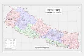 from Wikimedia Commons.

2) Add in text - Nepal had carried out census activity in Lipulekh 60 years ago. The census activity had covered 3 villages - Kunji, Navi, and Kuti and the Indian Army had tried to obstruct the endeavour then. https://www.timesnownews.com/international/article/nepal-wants-to-pull-off-census-in-indias-kalapani-limpiyadhura-lipulekh-scared-of-indian-armys-reaction/657472 RShrestha2018 (talk) 17:32, 23 January 2022 (UTC)
- Done. I added the information to the third paragraph in the lead and cited the Kathmandu Post source that was referenced in the source you provided. Thanks, Heartmusic678 (talk) 14:46, 31 January 2022 (UTC)
Extended-confirmed-protected edit request on 9 November 2022
editThis edit request has been answered. Set the |answered= or |ans= parameter to no to reactivate your request. |
Nepal never claim because it own territory so east India company took all Nepal area and handed to India 120.21.224.228 (talk) 11:16, 9 November 2022 (UTC)
 Not done: it's not clear what changes you want to be made. Please mention the specific changes in a "change X to Y" format and provide a reliable source if appropriate. Cannolis (talk) 04:00, 11 November 2022 (UTC)
Extended-confirmed-protected edit request on 11 November 2022
editThis edit request has been answered. Set the |answered= or |ans= parameter to no to reactivate your request. |
Please add "Category:Disputed territories in Asia" in article. 103.255.7.36 (talk) 11:07, 11 November 2022 (UTC)
 Not done: It is already in a subcategory of that category. – Jonesey95 (talk) 02:26, 12 November 2022 (UTC)