This article is within the scope of WikiProject Africa, a collaborative effort to improve the coverage of Africa on Wikipedia. If you would like to participate, please visit the project page, where you can join the discussion and see a list of open tasks.AfricaWikipedia:WikiProject AfricaTemplate:WikiProject AfricaAfrica articles
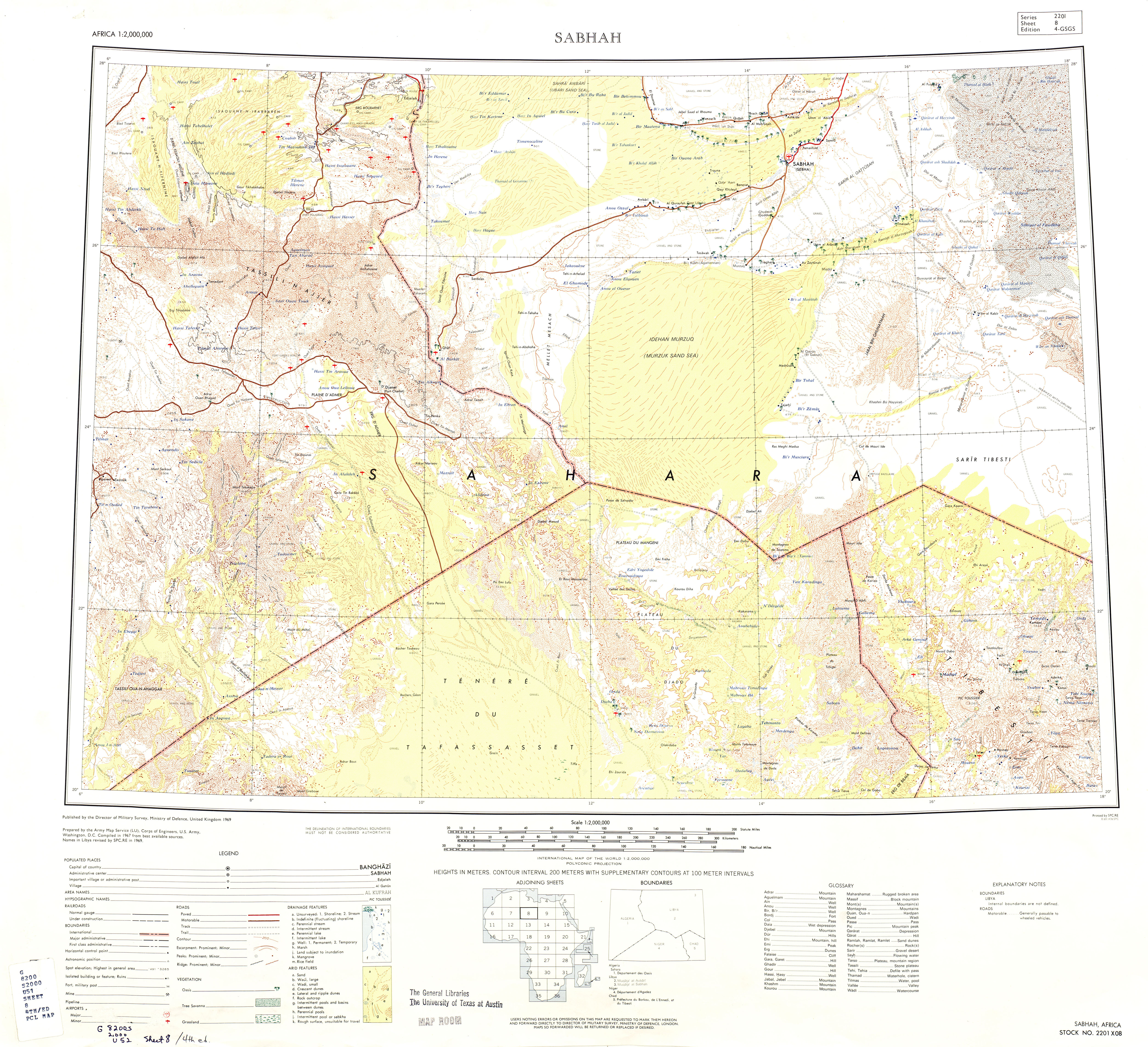
Yes this is confusing. It even says that even though it's located in Algeria, a portion of it is in Sudan? Sudan is far separated from Algeria. This map seems to indicate it barely even reaches the border of Libya. And the Sudan statement is unsourced... I think it must be incorrect. -kotra (talk) 23:28, 18 August 2015 (UTC)Reply
Kotra, this is the source. I read that to mean that "dune field" is something much broader and wider and "erg" indicates, and that all three mentioned ergs--in Libya, in Sudan, in Algeria--are part of the same dune field. It's a very big dune field. Drmies (talk) 01:33, 10 October 2015 (UTC)Reply
BTW, it seems to be even more complicated; this source suggests there's an Issaouane n'Tifernine and a Issaouane n'Irharhene. Pity there's no French article to lean on. Drmies (talk) 01:54, 10 October 2015 (UTC)Reply
Thanks for this, Drmies! I think you're right, the original source meant that Issaouane Erg is part of a dune field that extends as far as the "Sudanese Erg", whatever that is (maybe the Selima Sand Sheet in Egypt & Sudan?). I've changed the text accordingly.
For easy reference, this is what the sources you listed say in the Google preview:
"Another is located on the margins of the Ahaggar massif and becomes the Sudanese erg in the south and the erg of Issaouane in the north, flanked by the erg of Murzuk in Libya. Farther to the east the Tibesti massif is flanked by the ergs of..."
"Ce sont, dans la moitié occidentale, les grands ergs Issaouane n'Tifernine et Issaouane n'Irarraren, auxquels on peut associer les masses dunaires situées entre l'erg de Fort-Flatters - Gara Khanfoussa et les ergs d'Issaouane. L'autre moitié..."
Unfortunately that doesn't completely solve the location issues with this article - the coords listed of 31°11′N7°56′E / 31.18°N 7.93°E / 31.18; 7.93 place it in the Grand Erg Oriental (as the original poster in this section mentioned), which is separated from Issaouane in the map on this talk page. The Google preview for the source cited for the coords isn't very helpful.
Also, I think it is a little misleading for us to say that Issaouane Erg is located near the Ahaggar mountains (as that source seems to say), when the Tassili n'Ajjer mountains is closer, I think. It is annoying to have these sources unclear or contradictory on what should be a clearly defined geographic area. I know that the boundaries of ergs can shift with the movement of dunes, but they're usually constrained to a particular basin at least. -kotra (talk) 04:09, 10 October 2015 (UTC)Reply
Kotra, that same French source, page 220: there's two ergs, separated by the Essaoui Mellene. I'm not going to be able to solve this puzzle tonight, haha. Drmies (talk) 04:53, 10 October 2015 (UTC)Reply
Drmies yeah, it's all very confusing. After finally finding another map with it labeled (http://freevst.x10.mx/sahara/maps/sahara%20map%201.jpg, made between 1960 and 1975 judging by the country names), I think it's confirmed that our map on this talk page got it right. The best coordinates I can determine are about 27°50′N7°14′E / 27.83°N 7.23°E / 27.83; 7.23... which I've added to the article. If anyone comes by with a reference for something more exact that would be great - but at least it's not so confusing anymore. Thanks for all your help! -kotra (talk) 05:31, 10 October 2015 (UTC)Reply
No, thank you. And I'm getting back to this on Monday, with the help of my GIS colleagues. It irritates me when there's facts that ought to be accessible but aren't. Drmies (talk) 13:59, 10 October 2015 (UTC)Reply
Two things to clarify:
Issaouane Erg is a pleonasm. Issaouane means Erg in Tamahseq. Isaouane-n-Irarrarene means the same as Erg Irarrarene. So the title of the WP page would have to be changed.
On the map on the WP site, the Erg Irarrarene is shown too small, it extends much further south and has the shape of a triangle. The name of the erg is written on the French (and American) map approximately in the middle of this triangular dune area. The triangle has approximately the following coordinates: NE corner: 28° 30' N 9° E, NW corner: 28° 10' N, 6° 40' E. Southern tip: 26° 30' N, 8° 20' E (called "Menkhour"). The center of this triangle is approximately here: 27° 25' N, 7° 45' E.
On the IGN 1:200k Oued Samene map, the term Irrararen is noted, in the very south of the large dune area, where the landscape then changes into the Tassili-n-Ajjer (coordinates 26° 32' N, 7° 45' E). This indicates that the Erg Irarraren extends as far south as there. Heribertus2 (talk) 06:08, 4 September 2024 (UTC)Reply
A Commons file used on this page or its Wikidata item has been nominated for deletion


