This is the talk page for discussing improvements to the Holy Roman Empire article. This is not a forum for general discussion of the article's subject.
This article is within the scope of WikiProject Former countries, a collaborative effort to improve Wikipedia's coverage of defunct states and territories (and their subdivisions). If you would like to participate, please join the project.Former countriesWikipedia:WikiProject Former countriesTemplate:WikiProject Former countriesformer country articles
This article is within the scope of WikiProject History, a collaborative effort to improve the coverage of the subject of History on Wikipedia. If you would like to participate, please visit the project page, where you can join the discussion and see a list of open tasks.HistoryWikipedia:WikiProject HistoryTemplate:WikiProject Historyhistory articles
This article is within the scope of WikiProject Germany, a collaborative effort to improve the coverage of Germany on Wikipedia. If you would like to participate, please visit the project page, where you can join the discussion and see a list of open tasks.GermanyWikipedia:WikiProject GermanyTemplate:WikiProject GermanyGermany articles
Holy Roman Empire is within the scope of WikiProject Catholicism, an attempt to better organize and improve the quality of information in articles related to the Catholic Church. For more information, visit the project page.CatholicismWikipedia:WikiProject CatholicismTemplate:WikiProject CatholicismCatholicism articles
Holy Roman Empire is part of WikiProject Lutheranism, an effort to build a comprehensive and detailed guide to Lutheranism on Wikipedia. This includes but is not limited to Lutheran churches, Lutheran theology and worship, and biographies of notable Lutherans. If you would like to participate, you can edit the article attached to this page, or visit the project page, where you can join the project and/or contribute to the discussion.LutheranismWikipedia:WikiProject LutheranismTemplate:WikiProject LutheranismLutheranism articles
This article is within the scope of WikiProject Middle Ages, a collaborative effort to improve the coverage of the Middle Ages on Wikipedia. If you would like to participate, please visit the project page, where you can join the discussion and see a list of open tasks.Middle AgesWikipedia:WikiProject Middle AgesTemplate:WikiProject Middle AgesMiddle Ages articles
This article is within the scope of WikiProject Czech Republic, a collaborative effort to improve the coverage of the Czech Republic on Wikipedia. If you would like to participate, please visit the project page, where you can join the discussion and see a list of open tasks.Czech RepublicWikipedia:WikiProject Czech RepublicTemplate:WikiProject Czech RepublicCzech Republic articles
This article is within the scope of WikiProject Austria, an attempt to build a comprehensive and detailed guide to articles about Austria on Wikipedia. If you would like to participate, please join the project.AustriaWikipedia:WikiProject AustriaTemplate:WikiProject AustriaAustria articles
This article falls within the scope of WikiProject Netherlands, an attempt to create, expand, and improve articles related to the Netherlands on Wikipedia. If you would like to participate, visit the project page where you can join the project or contribute to the discussion.NetherlandsWikipedia:WikiProject NetherlandsTemplate:WikiProject NetherlandsNetherlands articles
This article is within the scope of WikiProject European history, a collaborative effort to improve the coverage of the history of Europe on Wikipedia. If you would like to participate, please visit the project page, where you can join the discussion and see a list of open tasks.European historyWikipedia:WikiProject European historyTemplate:WikiProject European historyEuropean history articles
This article is within the scope of WikiProject Greece, a collaborative effort to improve the coverage of Greece on Wikipedia. If you would like to participate, please visit the project page, where you can join the discussion and see a list of open tasks.GreeceWikipedia:WikiProject GreeceTemplate:WikiProject GreeceGreek articles
This article is within the scope of WikiProject Reformed Christianity, a collaborative effort to improve the coverage of Reformed Christianity on Wikipedia. If you would like to participate, please visit the project page, where you can join the discussion and see a list of open tasks.Reformed ChristianityWikipedia:WikiProject Reformed ChristianityTemplate:WikiProject Reformed ChristianityReformed Christianity articles
This article is within the scope of WikiProject Silesia, a project which is currently considered to be inactive.SilesiaWikipedia:WikiProject SilesiaTemplate:WikiProject SilesiaSilesia articles
This article is within the scope of WikiProject Frisia, a project which is currently considered to be inactive.FrisiaWikipedia:WikiProject FrisiaTemplate:WikiProject FrisiaFrisia articles
Suggestions generated by an automatic JavaScript program, and might not be applicable for the article in question.
The lead of this article may be too long, or may contain too many paragraphs. Please follow guidelines at WP:LEAD; be aware that the lead should adequately summarize the article.[?]
The lead is for summarizing the rest of the article, and should not introduce new topics not discussed in the rest of the article, as per WP:LEAD. Please ensure that the lead adequately summarizes the article.[?]
Per WP:WIAFA, this article's table of contents (ToC) may be too long – consider shrinking it down by merging short sections or using a proper system of daughter pages as per Wikipedia:Summary style.[?]
Please make the spelling of English words consistent with either American or British spelling, depending upon the subject of the article. Examples include: neighbor (A) (British: neighbour), defence (B) (American: defense), organize (A) (British: organise), recognize (A) (British: recognise), recognise (B) (American: recognize), ization (A) (British: isation), isation (B) (American: ization), travelled (B) (American: traveled).
Watch for redundancies that make the article too wordy instead of being crisp and concise. (You may wish to try Tony1's redundancy exercises.)
Vague terms of size often are unnecessary and redundant - “some”, “a variety/number/majority of”, “several”, “a few”, “many”, “any”, and “all”. For example, “All pigs are pink, so we thought of a number of ways to turn them green.”
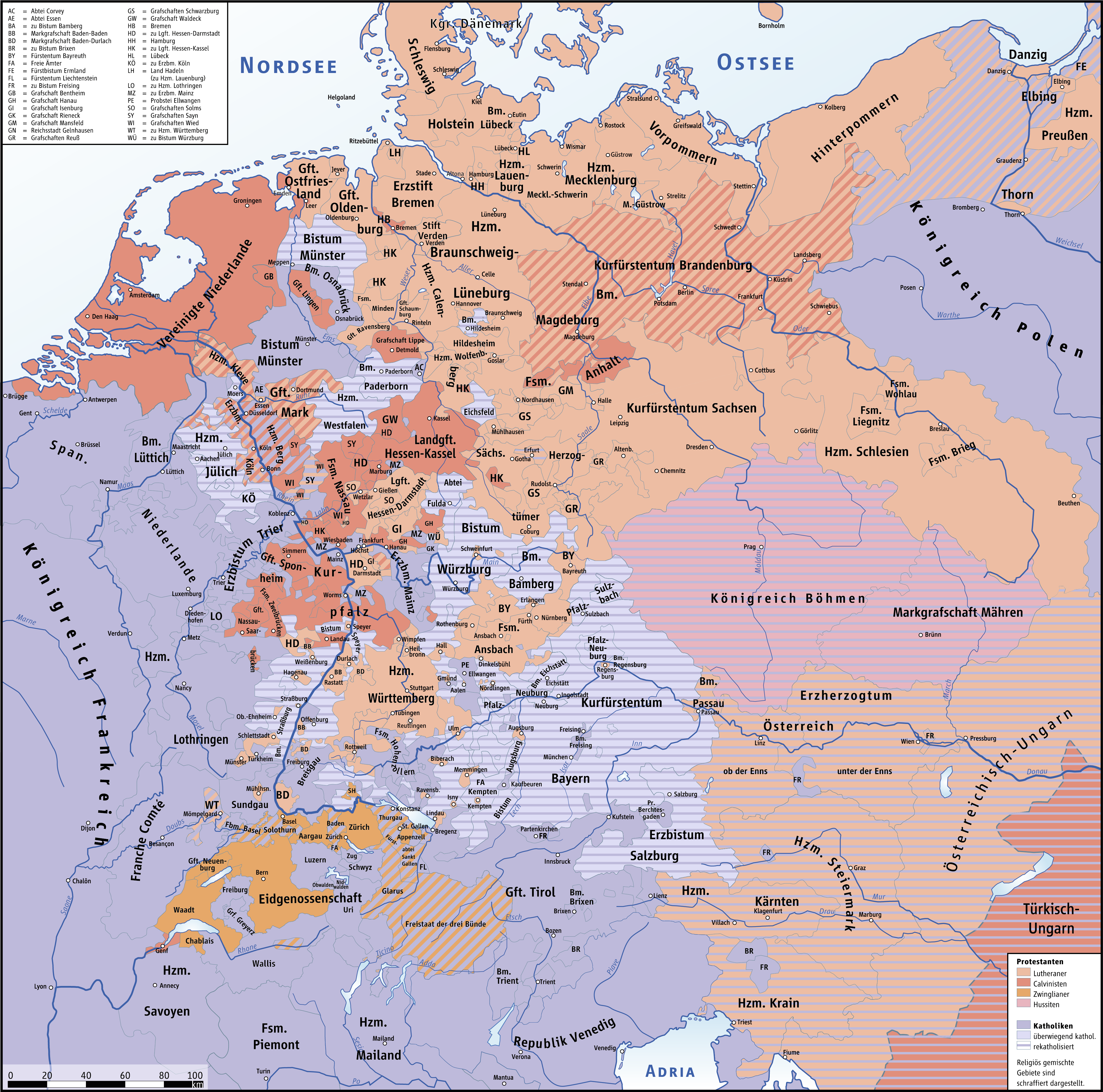
I think this is also true for the region around Marburg (including the town itself), which became Calvinist in December 1606 and remained so until Ludwig V's case against this was enforced by Tilly in the spring of 1624. I don't understand why that part of Hesse-Kassel is not labelled Calvinist, like the rest of that territory. Compare the shaded red region in the left map here. Renerpho (talk) 06:45, 26 November 2023 (UTC)Reply
I have temporarily removed the map,[2] to allow for the inaccuracies to be fixed, and (if found necessary) to check whether there are additional errors beyond the ones I had mentioned in my original post six weeks ago. Renerpho (talk) 02:03, 5 January 2024 (UTC)Reply
The map is currently being worked on. The errors I mentioned above have been corrected. A number of possible additional errors about the surrounding regions are currently being discussed on the creator's user talk page. With that, all the places about which I know enough to recognize mistakes (in the map, that's HD, Hessen-Kassel, SY, and Fsm. Nassau) will have been checked and corrected, so my work on this will soon be over. However, given that all of them have been labelled incorrectly, it may be worth to have an expert check the rest of the map... In any case, I am happy to add the map back as soon as the last remaining corrections have been made. Renerpho (talk) 01:47, 15 January 2024 (UTC)Reply
Latest comment: 5 months ago1 comment1 person in discussion
Dear restless IP, since this seems very important to you and you interpret the source UNIO REGNI AD IMPERIUM in "Federiciana" as if Sicily was part of the Empire from 1194 until the end of the Hohenstaufen dynasty, let's discuss.
The infobox map was already discussed in two sections (1, 2) of the last archived discussion page, also in this section several years ago. One consent was that Sicily was reigned by the Hohenstaufen emperors in personal union. The given source UNIO REGNI AD IMPERIUM explains how the Hohenstaufen, especially Henry VI, claimed Sicily for the Empire, established their rule in the right of Queen Constance, but then Henry failed with his Erbreichsplan that could have united the Empire and Sicily. The source speaks of a personal union, not of Sicily as part of the Empire. Another consent in previous discussions was that the map should only include parts of the Empire, not dependencies, and in no way it should include Venice. A later discussion adressed factual errors of the previously used maps like the inclusion of Sardinia which was claimed by the Hohenstaufen one time but never actually got under their control. Palastwache (talk) 11:21, 9 February 2024 (UTC)Reply


.svg)
.svg)


.svg)