| This is the talk page for discussing improvements to the Gough Map article. This is not a forum for general discussion of the article's subject. |
Article policies
|
| Find sources: Google (books · news · scholar · free images · WP refs) · FENS · JSTOR · TWL |
A fact from Gough Map appeared on Wikipedia's Main Page in the Did you know column on 6 February 2008, and was viewed approximately 10,000 times (disclaimer) (check views). The text of the entry was as follows:
|
| This article is rated Start-class on Wikipedia's content assessment scale. It is of interest to the following WikiProjects: | ||||||||||||||
| ||||||||||||||


New research and published research
editThe Gough Map entry needs some revision. CharlburyNick has added a new section (4: Recent Research), and this draws attention to not only recent unpublished research but also to five peer reviewed articles in Imago Mundi (all since 2009). These articles arrive at different conclusions from each other, but all of them present a challenge to the current Wikipedia entry - which seems to be based on outdated literature.
- The dating is the most obvious problem. I'm not aware that anyone in the past 5 years has put such an early date (1366) on the map. From published works, Solopova (2012) says 1370/1400+; Smallwood (2010) goes as far as 1420. The new unpublished research (outlined at a recent Bodleian Library symposium) suggests several stages, between 1370 and mid-to end 15th century.
- Perhaps the emphasis on 'route map' and 'road network' should be toned down a bit. The red distance lines are very far from being any sort of road network. I think it will be possible to modify the wording to be consistent with recent published work.
- There are a few dead links, and one link to a low quality press article. The new citations could do with hyperlinks, on the doi numbers, etc.
I intend to make a few changes to bring the entry into line at least with the latest published material, if not quite with current thinking. Hopefully I can account fairly for differing views.
Is there anything I need to know before I start? Any objections?
Kutya elet ez (talk) 16:22, 16 March 2016 (UTC)
- Since its 2015 work in progress research and the final findings wont be published till 2017 it may be worth holding off making any changes until that final report. WatcherZero (talk) 19:19, 16 March 2016 (UTC)
Thanks for the reply. I understand that this isn't the place to air unpublished research - frustrating as that is. I hope it is acceptable to draw attention to it, though, as CharlburyNick has done. It seems odd not to refer to such a large project and symposium based at the home of the Gough Map.
I see that in 2008 the 'Did you know' column had this 'fact' about the Gough Map: "..that the Gough Map, housed at the Bodleian Library in Oxford, is the oldest surviving road map of Great Britain and is believed to date from sometime between 1355 and 1366?". That's not what the more recent studies say. What I am proposing to do is bring the Wikipedia entry into line with the peer-reviewed, published research. I wouldn't like Wikipedia readers to be getting out of date conclusions for another year or more. Kutya elet ez (talk) 20:31, 16 March 2016 (UTC)
- @Kutya elet ez: What you propose is exactly what the article needs. I've fixed the issue with DOIs not being linked. Naturally, Wikipedia has to be on guard against hoaxes, and is very cautious about making statements about the future and that's why there needs to be a checkable reference for any statements of fact. Was there a blog post or other online summary of the symposium on a university or other scholarly site? MartinPoulter (talk) 12:33, 17 March 2016 (UTC)
- @MartinPoulter: Good question! I'm not sure if there is a blog post. There should be. Anyway I need to find references for Section 4. There's the Bodleian page advertising the Symposium; a BBC news article about the various technologies being used on the map, with quotes from Bodley people (does that count as verifiable?); the websites of the tech providers have a bit about that too. I'll collect what I can. What we lack at the moment is a credible summary of the findings. If none are forthcoming, what do we do? Remove them? Couch everything in vaguer terms? Kutya elet ez (talk) 14:25, 17 March 2016 (UTC)
- @Kutya elet ez: News articles from reputable "broadsheet" sources are fine: this includes the BBC, so that sounds like an ideal source. (There's a hierarchy of sources, so a peer-reviewed journal would be trusted more than a newspaper, a review of research more than a single research paper, and so on.) If you're using the Visual Editor, click the Cite button, then paste in the web address of the BBC article and it will automatically format a citation. Wikipedia policy says that if no source is available yet, then a summary should not be in the article, but, as you say, there is lots of already-published material to improve the article with. I know this can be frustrating - this is general problem when people with specialist knowledge contribute to Wikipedia, but the principle that all facts have to be checkable or "verifiable" is core to how the site works. MartinPoulter (talk) 14:46, 17 March 2016 (UTC)
- @MartinPoulter: We have a report on the web page of ISHMap (The International Society for the History of the Map), posted by a reputable person. I'll collect all the references together- good and less good - and perhaps you'd be kind enough to judge them for credibility. Thanks! Kutya elet ez (talk) 14:38, 17 March 2016 (UTC)
- @Kutya elet ez: Sounds good. Using blog or web-page posts is generally frowned upon, but when it's verifiably by an expert, and they are explaining a mainstream view of their subject, then it's usually admissible. Cheers, MartinPoulter (talk) 14:48, 17 March 2016 (UTC)
The late Tom Martin?
edit@Dweller: I agree that 'late' seems a bit odd, but the wording needs to explain that Martin had died by this time. The original wording probably comes from Nick Millea's book, but in that book the author then goes on to explain the sequence of events. I'll post the important details here later, and perhaps come up with a new phrase. Thanks. Kutya elet ez (talk) 08:36, 18 March 2016 (UTC)
- For the purposes of an encyclopedia article (as opposed to an academic journal article), I'm not sure it's a critical piece of info, but we could word it less clumsily (from the estate of? heirs of?). It doesn't help that the reference is a deadlink. --Dweller (talk) Become old fashioned! 08:57, 18 March 2016 (UTC)
I noticed the dead link. I'm collecting new ones - hopefully from the Bodleian Library site. ...from the estate of... sounds better - but I'll check the exact circumstances. For example, was it an auction, or another type of sale? Even if the reader doesn't need to know all the details, it might help with the wording. Kutya elet ez (talk) 09:18, 18 March 2016 (UTC)
- Do we really need that level of detail on the provenance? Surely the encyclopedia reader is more interested in the map than exactly how dead a dead person was when they finished owning it? --Dweller (talk) Become old fashioned! 09:23, 18 March 2016 (UTC)
Certainly the first paragraph isn't the place for loads of detail - but 'acquired from the estate of' better reflects what happened. I would like to read a bit more about it, just to make sure. For example, I don't know why it says 'he is believed to have acquired...'; I thought that was pretty well established how he got it. Perhaps I'm wrong. More generally, the map's provenance is an important part of its history, and would probably merit a section of its own. Kutya elet ez (talk) 09:42, 18 March 2016 (UTC)
- OK, sounds sensible. Needs some decent sourcing. Fascinated by this "not a road map" argument. --Dweller (talk) Become old fashioned! 10:17, 18 March 2016 (UTC)
@Dweller: The source for how Gough acquired the map is himself: Richard Gough, British Topography. Or, an Historical Account of What has been Done for Illustrating the Topographical Antiquities of Great Britain and Ireland (London, 1780), p.76. On googlebooks: https://books.google.co.uk/books?id=Oc8HAAAAQAAJ&pg=PA76#v=onepage&q&f=false Also here: http://www.goughmap.org/contexts/historiography-and-prosopography/ "The late Mr. Thomas Martin shewed to the same society (Soc. of Antiquaries) at the same time (1768) a map on vellum, which he supposed to be of the age of Edward III in which the names of London and York were distinguished by large gold letters. This map I purchased at a sale of his MSS, 1774, and shall subjoin the following account of it, to illustrate the copy made by Mr. Basire, pl VI. It is drawn on two skins of vellum, in a style superior to any of the maps already described... The roads are marked by lines, and even the miles in each stage. But the greatest merit of this map is, that it may justly boast itself the first among us wherein the roads and distances are laid down".
Shall we say 'He acquired the map from the estate of...' - removing 'It is believed' and 'collection of'? Kutya elet ez (talk) 10:45, 18 March 2016 (UTC)
@Dweller: Road map or not? The argument against is (briefly): 1) The red lines do not follow the paths of known roads. They are simply distance lines between two points. e.g. Two red lines radiate to different towns, even though the journey is for the most part along the same road. 2) Many obvious routes are omitted. 3) The vast majority of settlements, and large areas of the map (everything north of the wall), have no red lines. They seem not to have been of primary concern to the creators of the map (though perhaps they were to later users). Again, I'll have to find sources before I meddle with that subject. Kutya elet ez (talk) 11:02, 18 March 2016 (UTC)
Imago Mundi section
editI have multiple issues with this: "Traditional conclusions about other aspects of the map were revised, including many transcriptions of place-names and the identification of some places represented on the map. The origin of the red lines that link certain places remains unclear, but it has been established, contrary to popular belief, that they neither represent roads nor do they amount to a coherent ‘national’ network. The function of the dense but unsystematic scatter of pinholes has not yet been discovered. On-going research extends the number of regional case studies already carried out (Northwest England, North Norfolk coast). New discoveries have also been made about the subsequent history of the map. Pending a substantial publication, all findings to date will be summarised in an article planned for a forthcoming issue of Imago Mundi (vol. 69, 2017). First, it's way too definitive. "it has been established, contrary to popular belief, that they neither represent roads nor do they amount to a coherent ‘national’ network" should be toned down to "it has been argued". Similarly, the opening clause of the first sentence "were revised" Secondly, the last sentence is a blatant advert. Thirdly, the existence of pinholes hasn't previously been mentioned in the article. Fourthly, what the heck does this mean "Traditional conclusions about other aspects of the map were revised, including many transcriptions of place-names"? What conclusions about transcriptions of place-names were revised? --Dweller (talk) Become old fashioned! 10:21, 18 March 2016 (UTC)
- @Dweller: :@MartinPoulter: I've been discussing this (above) with MartinPoulter. I'm collecting references for everything that can be referenced. The rest may have to be reworded or removed. Would it be wiser to remove it and then replace it when there's some agreement? Kutya elet ez (talk) 10:30, 18 March 2016 (UTC)
- Maybe. It can be worked in a sandbox. --Dweller (talk) Become old fashioned! 10:33, 18 March 2016 (UTC)
Date
editThis section needs to take more views into account. It is true that the Coventry/Queenborough evidence has led some to place the map in a very narrow window (1355 -1366), but more recent palaeographic studies have put it rather later. One of those (Smallwood) tackles the Queenborough theory head on.
Firstly, I think 1355/66 needs to be removed from the introduction. It can more fairly be described as dating from the Late Middle Ages (an existing Wikipedia subject). Then the Date section can be changed to accommodate the different views. Kutya elet ez (talk) 13:07, 25 March 2016 (UTC)
Proposed revised text for the Date section. Citations are already elsewhere on the page - I'll link them later, and find new links for the dead ones. I'd welcome suggestions re. grammar and style.
"Thomas Martin believed the map to date from the reign of Edward III. 19th-century scholarship suggested that it dated from c. 1300, during the reign of Edward I. More recently, the map was believed to have been made within an eleven-year window, based on historical changes of place names and sizes. The earliest given date is deduced by the depiction of a city wall around Coventry, which was first constructed in 1355. The latter date is usually given as 1366, the year in which the town marked on the map as Sheppey was renamed Queenborough.
Later studies, based on handwriting and stylistic evidence, support a later period of production. One study concludes that the map must have been made in the early years of the fifteenth century, while another suggests that the map was produced in the 1370s but extensively revised, perhaps as late as 1430.
It is generally accepted, however, that the map is one of several similar copies based on a prototype made around 1280 and reflecting the interests of Edward I." [Note: As some of the links are dead it's impossible to know whether the Wikipedia text reflected the cited text. For example, regarding Gough's opinion about the date, I can only find his reporting of Martin's opinion. Unless something else comes to light, I'm sticking with that.] Kutya elet ez (talk) 00:43, 27 March 2016 (UTC)
Topography, road network and accuracy - split
editI propose to remove the part about the 'road network', and create a new section called 'The Red Lines', for red lines is what they are. The different interpretations can then be aired. The distinctions between 'roads', 'road network', 'road map','route' and 'distance lines', and so on, are crucial to how the map is understood. And there's no shortage of peer reviewed opinions on the subject.
I would like to remove the bit about 'leagues'. It isn't referenced, and I have no idea where it could have come from. Kutya elet ez (talk) 22:27, 30 March 2016 (UTC)
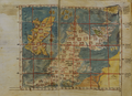
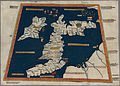
It was also the first map to depict a recognisably accurate picture of Britain's coast
editThis is only partially true. The map of Albion in Ptolemy's Geography has clearly recognisable contours of the southern part, and better contours for Scotland than the Gough map, although unfortunately there's a 90° bend around Hadrian's wall that isn't there in reality. So I think this needs rephrasing and I also think some version of Ptolemy's Albion should be shown for comparison. — Preceding unsigned comment added by 80.114.146.117 (talk) 11:23, 22 June 2016 (UTC)
I agree. Both terms - 'first' and 'recognisably accurate'- are open to dispute, and probably best avoided. Can you think of new wording? Or I'll try to, and see if there's a Ptolemy we can use. Kutya elet ez (talk) 19:38, 22 June 2016 (UTC)
We've already got the following images of early maps based on Ptolemy's Geography:
-
 Early 14th C.
 -
 Between 1450 and 1475
 -
 1462
1462 -
 1486
1486 -
 Ca. 1490
 -
 1578
1578


.jpg)

Or we could make our own plot based on [1].
As for a rephrasing, how about this as a starting point:
- It also greatly improves the detail on the coast of England and Wales as compared to previously known maps, like Ptolemy's Geography, although its depiction of the then autonomous Kingdom of Scotland is very poor.
Or maybe:
- And compared to previously known maps, like Ptolemy's Geography, it greatly improves the detail on the coast of England and Wales, although its depiction of the then autonomous Kingdom of Scotland is very poor.
16 July: I've taken the liberty to edit the article. — Preceding unsigned comment added by 80.114.146.117 (talk) 17:22, 16 July 2016 (UTC)
Hoax
editIs it an 18 Century hoax or publicity stunt? 2A00:23C7:91AB:BC01:6070:CDFF:7750:6B8F (talk) 20:28, 10 September 2022 (UTC)
- Haven't seen anything to suggest that. --Auric talk 19:10, 2 November 2023 (UTC)
External links modified
editHello fellow Wikipedians,
I have just modified 2 external links on Gough Map. Please take a moment to review my edit. If you have any questions, or need the bot to ignore the links, or the page altogether, please visit this simple FaQ for additional information. I made the following changes:
- Added archive https://web.archive.org/web/20080510221010/http://www.bodley.ox.ac.uk/users/nnj/goughmap.htm to http://www.bodley.ox.ac.uk/users/nnj/goughmap.htm
- Added archive https://web.archive.org/web/20080417195420/http://www.oxfordtoday.ox.ac.uk/2005-06/v18n2/08.shtml to http://www.oxfordtoday.ox.ac.uk/2005-06/v18n2/08.shtml
When you have finished reviewing my changes, you may follow the instructions on the template below to fix any issues with the URLs.
This message was posted before February 2018. After February 2018, "External links modified" talk page sections are no longer generated or monitored by InternetArchiveBot. No special action is required regarding these talk page notices, other than regular verification using the archive tool instructions below. Editors have permission to delete these "External links modified" talk page sections if they want to de-clutter talk pages, but see the RfC before doing mass systematic removals. This message is updated dynamically through the template {{source check}} (last update: 5 June 2024).
- If you have discovered URLs which were erroneously considered dead by the bot, you can report them with this tool.
- If you found an error with any archives or the URLs themselves, you can fix them with this tool.
Cheers.—InternetArchiveBot (Report bug) 14:03, 23 March 2017 (UTC)