Talk:Calderone glacier
| This article is rated Start-class on Wikipedia's content assessment scale. It is of interest to multiple WikiProjects. | |||||||||||||||||||||
| |||||||||||||||||||||


Gone now?
editAccording to (this source)[1] the glacier finally melted in 2016. —MarkN (talk) 13:07, 19 August 2020 (UTC)
- Per that source:
- L'Aquila-based mountaineer Paolo Boccabella said "the situation is dramatic this year: the glacier has disappeared not at the end of summer but already in mid-August"...Meteorologists said ice remained under the gravel.
- So, it would seem 1) the glacier has disappeared in past years but later than in 2016, and 2) the glacier might still be present under gravel. This would seem to all depend on the definition of glacier. So, the 2016 melt might not be 'final'. Tfdavisatsnetnet (talk) 05:16, 21 December 2022 (UTC)
Prokletije mountains could include the Europe's most southern glacier
editRecent discovery of 4 glaciers in Prokletije mountain range (Albania), link: http://www.manchester.ac.uk/aboutus/news/display/?id=5393 puts in slight doubt Calderone's primate as the Europe's southernmost glacier. Calderone Glacier sits at 42°28'17" N.
The linked article doesn't precisely locate the location of newfound glaciers, so the claim cannot be yet validated and needs further investigation.
But to sum up already known facts: Prokletije's highest parts are in Albania, generally between 42°22' and 42°30' N, so it is quite likely that one of mentioned 4 glaciers is south of 42°28'17" line.
I suggest Calderone stays proclaimed as the official Europe's southermost glacier with additional information of moderate possibility that Prokletije mountains include even souther glacier(s).
P.S. In article http://en.wikipedia.org/wiki/Prokletije there is a statement (3rd paragraph): "Southernmost glaciers in the Europe were recently discovered in Albanian part of the range.". The title of the southernmost glacier in Europe probably cannot go to two different glaciers in Europe at the same time, so the mess should be cleared up as proposed (Calderone addressed as official, Prokletije inofficial) and both Calderone (+Gran Sasso +Corno Grande) wikipage and Prokletije wikipage should be corrected in that manner. What others think? 77.38.44.85 (talk) 13:52, 23 October 2010 (UTC)
- I've added a discussion about which one is more southern on Talk:Prokletije. -Apocheir (talk) 17:34, 25 April 2017 (UTC)
- I place a copy of my comment here as well: Well, on the matter of Europe's Southernmost Glacier I have a lot to say. First of all, the title goes to different geographic or glacial features, depending on the definition of a glacier. There are bodies of ice (glacierets) in Southern Europe, as I will mention some of them, which are situated further South. Second of all, I have been on and around some of these and can personally testify about their eligibility if asked. I can provide both numerous photographs as well as description of their features, as I have walked on some of them.
- 1) Let's start with the previous holder of the title - Corral de la Veleta beneath the North Face of Veleta (3394 m) in Sierra Nevada with a latitude of 37°03'31" N and an altitude of about 3100 m, which disappeared in 1913.
- 2) The Northernmost of the current claimants - Debeli Namet in Durmitor is massive enough, but is at a latitude of 43°06'53" N and at an altitude between 2050 and 2250 m. It is situated under the vertical cliffs of the N Face of Šljeme (2455 m), which hide it from the Sun. It is mostly avalanche fed. I visited the mountain in the spring of 2011.
- 3) The numerous glaciers in the Maladeta Massif in the Pyrenees are all around 42°38' - 42°39' N - namely the ones on the slopes of Aneto (3404 m) and Maladeta (3312 m). Perhaps one could find glaciers further South in the mountain but I doubt any would pass the 42°30' N mark, whereas the other claimants all lie behind it.
- 4) The Calderone beneath the NE slopes of Corno Grande (2912 m) in the Gran Sasso Massif of the Apennines is at a latitude of 42°28'15" N and an altitude between 2680 and 2730 m. It is likely to disappear in the next few years.
- 5) The Southernmost (to my knowledge) claimants are the two glacierets in the Pirin mountain in SW Bulgaria. They are patches of ice covered with firn and snow, and are fed mostly by avalanche snow. The slightly Northern one - Banski Suhodol is at a latitude of 41°46'55" N and an altitude between 2630 and about 2700 m, at the NW Face of Kutelo (2908 m), while the better studied Southern one - Snezhnika in the Golyam Kazan cirque, below the N Face of the highest peak in the mountain - Vihren (2914), is at a latitude of 41°46'09" N and at an altitude between 2425 and 2480 m. it has been monitored by Bulgarian scientists for the best part of the 20th century and today.
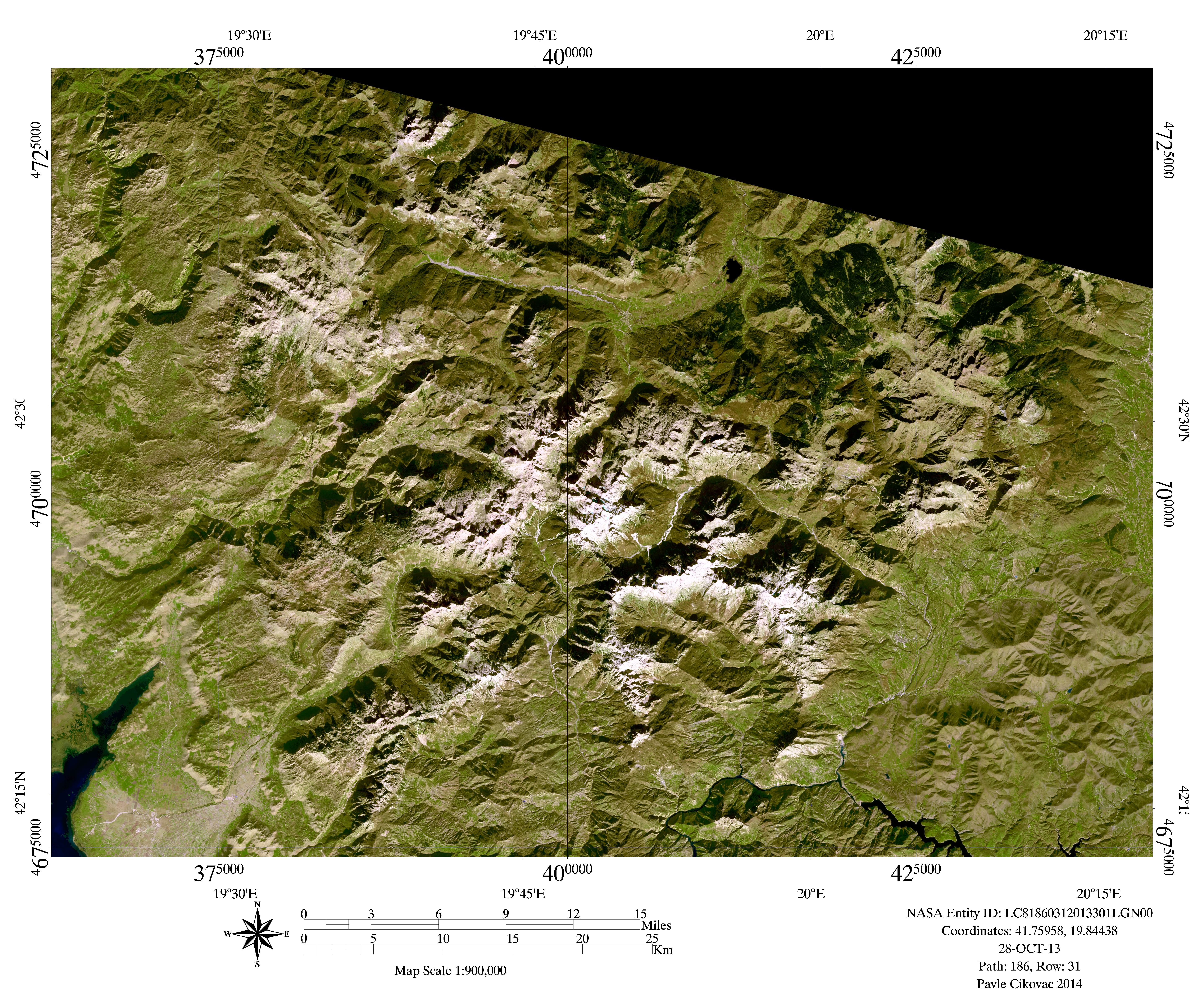
- 6) And last but not least - the glaciers in Prokletije. I visited the mountain in the end of August 2015. I was lucky to be there in a mostly dry year. That caused many of the lakes to disappear, as well as almost all snow from the previous winter to vanish, revealing the solid ice bodies to the surface. I can tell that by comparing photos of mountaineers who were there in the previous several years. I have numerous photos that show the difference and the sharp boundary between the ice and the packed snow from the winter. I have tested three of these with my crampons and can testify they are hard as glass, although their appearance is as dirty brownish frozen waves. The reason this mountain has so much ice and snow is simple - it rises straight from the shores of the Adriatic sea and is the first to meet the moisture coming from it. As a result it rains here almost every day. Rain water is drained quickly since the mountain consists mostly of limestone, while snow is much more ready to accumulate. I should also note that there are far more than just 4 glaciers or patches of ice. I myself have identified more than twenty on and beneath the sharp Northern faces of just three peaks - Maja e Malësores (2490 m), Maja Jezercë (2694 m), and Maja e Popljuces (2569 m). They are all between and around 42°26' and 42°27' N, with the Southernmost three being at latitudes of about 42°25'52" at he top to about 42°26'01" N at the head. If you have a good look (zoom in) at this picture, made by the Landsat 8 satellite in 2013, you could easily identify much more - the cyan blue colour is a tell sign: [Prokletije Glaciers Satellite].
- Finally, here is an improvised list that summarizes the above information. Latitudes are approximate and are from the lowest parts of the ice bodies, while altitudes are even more inaccurate, since I used Google Earth - just for a comparison purpose. For Prokletije I note where I have personal photos and I have also put external (Panoramio) links to photos of some of the areas in question, taken by others:
Corral de la Veleta 37°03'31" N 03°21'54" W 3100 m Sierra Nevada Veleta (3394 m) N Face; Disappeared in 1913
Debeli Namet 43°06'53" N 19°04'02" E 2050-2250 Durmitor Šljeme (2455 m) N Face
Aneto			42°38'04" N	00°39'20" E	2970-3250	Pyrenees	Aneto (3404 m) N Face
Barrancos		42°37'52" N	00°39'45" E	3000-3380			Aneto (3404 m) NE Face
Las Tempestades	     42°38'00" N	00°39'25" E	3200-3300			Aneto (3404 m) NE Face
Coronas / Coronado	42°37'54" N	00°39'01" E	3100-3320			Aneto (3404 m) W Face
Cregüella										Aneto (3404 m); immobile glacieret
Alba											Aneto (3404 m); immobile glacieret
Salenques										Aneto (3404 m); immobile glacieret
Maladeta		42°38'50" N	00°38'22" E	91-acre (37 ha)	Pyrenees	Maladeta (3312 m) N Face
 Eastern Maladeta					77-acre (31 ha)
 Western Maladeta					15-acre (6 ha)
Calderone 42°28'15" N 13°34'03" E 2680-2730 Apennines Gran Sasso, Corno Grande (2912 m)
Banski Suhodol 41°46'55" N 23°23'40" E 2630-2700 Pirin Kutelo (2908 m) NW Face; glacieret
Snezhnika 41°46'09" N 23°24'10" E 2425-2480 Pirin Vihren (2914 m) N Face; glacieret [2]
Maja e Malësores (2490 m): Prokletije
 NW Cirque Bed		42°27'13" N	19°47'55" E	2010	Photos & Walked [3]

 NE Cirque Bed	1	42°27'00" N	19°48'05" E	2090	Photos & Walked [4]

 NE Cirque Bed	2	42°27'01" N	19°48'11" E	2080	Photos & Walked [5]
Maja Jezercë (2694 m):							Prokletije

 NW Face 1		42°26'45" N	19°48'24" E	2350	- [6]

 NW Face 2		42°26'45" N	19°48'34" E	2370	- [7]

 N Face 1		42°26'44" N	19°48'49" E	2350	Photos Close By (30-40 m) [8]

 N Face 2		42°26'40" N	19°48'54" E	2360	Photos Close By (~200 m) [9]

 N Face 3		42°26'36" N	19°49'00" E	2380	-
 NE Face 1	      	    42°26'24" N	19°49'01" E	2410	Photos from Maja Jezerce

 NE Face 2		42°26'22" N	19°49'06" E	2380	Photos from Maja Jezerce

 NE Face 3		42°26'19" N	19°49'17" E	2340	Photos from Maja Jezerce

 NE Cirque Bed		42°26'45" N	19°49'07" E	2190	Photos from Col ~2300 (Maja Kokervhake - Maja Jezerce) [10]
Maja Popluks / Maja e Popljuces (2569 m):				Prokletije

 N Face 1a 	42°25'52" - 42°25'55" N	19°48'23" E	2380	Photos from Maja Jezerce

 N Face 1b		42°25'59" N	19°48'23" E	2340	Photos from Maja Jezerce

 N Face 2a 	42°25 52" - 42°25'54" N	19°48'16" E	2400	Photos from Maja Jezerce

 N Face 2b		42°26'00" N	19°48'16" E	2330	Photos from Maja Jezerce
 N Face 2c		43°26'06" N	19°48'20" E	2260	Photos from Maja Jezerce

 N Face 3		42°26'00" N	19°48'04" E	2310	Photos from Maja Jezerce

 N Face 4a 	42°25'54" - 42°26'01" N	19°47'54" E	2420-2320 -

 N Face 4b		42°26'10" N	19°47'57" E	2150	Photos from Maja Jezerce
- Hope it helps for a fruitful discussion!--Bobbylon (talk) 03:16, 25 May 2017 (UTC)