Talk:Banovina of Croatia
| This is the talk page for discussing improvements to the Banovina of Croatia article. This is not a forum for general discussion of the article's subject. |
Article policies
|
| Find sources: Google (books · news · scholar · free images · WP refs) · FENS · JSTOR · TWL |
| This article is rated Start-class on Wikipedia's content assessment scale. It is of interest to the following WikiProjects: | |||||||||||||||||||||||||||||||
| |||||||||||||||||||||||||||||||


Here we go again...
edit- I will not stand for your NDH legitimacy pushing. Take a gander at the Kingdom of Yugoslavia article. It is packed full of sources about that state, sources which have led to the User consensus on representing it as lasting either up to 1943, or even up to 1945. If you believe that the Banovina of Croatia, an administrative subdivision of the Kingdom of Yugoslavia, somehow ceased to exist before the Kingdom of Yugoslavia itself, you are talking nonsense. Nonsense again motivated by your consistent POV-pushing in the direction of "legitimizing" the fascist Independent State of Croatia (NDH), by diminishing the representation of the legal Croatian WWII entities in every conceivable way.
- Was the Banovina of Croatia succeeded by the NDH when it "ceased to exist" in 1941? Hmmm?? I wonder if you'll answer that... because writing up DFY or FS Croatia as the successors in 1941 is an utter travesty (and you know it).
- I am supremely indifferent as to whether or not you consider the word "puppet" to be unnecessary by your own opinion. It is correct, it is sourced, and removing it is clear POV-vandalism aimed at destroying factual accuracy by not mentioning crucial facts about a mentioned state's status. If I wish to add more detail to this article, you have absolutely no right to remove it because you don't like it personally.
- It may be incorrect to write up the FS Croatia as the successor, and you may have a point there... While both have arguments, I've been considering switching the 1943 successor state to DF Yugoslavia myself. If you object to the current successor, this alteration is fine. --DIREKTOR (TALK) 22:01, 9 July 2009 (UTC)
Discuss issues and not your believes
edit- (1) You are pushing POV as if the ISC never existed, you even tryed to remove it from the Template:History of Croatia. Its existence cannot be removed. It cannot be removed because you and me both would regard it obsolete and harmful towards Croatia, or because it was or wasn’t a state, but because it existed and history do not judge states, nations, etc. but regimes and individuals.
- (2) you and simmilar POVers continue your rude attempt to include in almost every article where the ISC is mentioned the phrase "puppet" (natturaly with a sentence or two about its creation, and such sentences). This is simply wrong, Banovina of Croatia has nothing to do with the ISC. Its history cannot be "tainted" with any description of what happened latter. We have the ISC article for that.
- (3) By using POV like ISC was not independent, a state, or Croatian is diminishing the responsability of that state in every conceivable way. The ISC had been a state created after the torture and the dictatorship of the Kingdom of Yugoslavia, it was created with the help of the Axis, it was legaly created since Italy and Bulgaria were not States Parties of the Hague Conventions (and the Kingdom of Albania under the House of Savoy also) + there were no international law on how states gain independence or statehood, even today that chapter of international law is being written (Kosovo). It is a completely different story the regime (Ustashi) or the legal system (dictatorship with limited assembly — written with small caps)
- (4) Banovina of Croatia as an administrative and federal unit ceased to exist in 1941, this can be proven by reading some of notable historians (all of them are not belevolent towards the ISC), Croatian Peasent Party members that went with the Royal Govt in Exile tryed to protect the Cvetković-Maček Agreement for the re-creation of the Banovina of Croatia after the war — but without no assurances for that re-creation.
- (5) No concensus (you have not even provided a precise link) is for all times'. Your POV is clear to us all, you defend the theory of the Kingdom of Yugoslavia existing on paper but fail to provide on what basis did the Allies recognize the Royal Govt in Exile. Before Teheran the Soviet had not recognized the Royal Govt in Exile but only the Partisans. After that (in Nov 1943) a compromise was made and the other two major Allied Powers (US and UK) recognized Partisans while the USSR recognized a 50/50 policy on the after war influence over Yugoslavia. At that point in time the Allied decided to re-create Yugoslavia after the war as a equall joint venture partnership and not the Kingdom of Yugoslavia under the Karageorgevitch.
- (6) Banovina of Croatia was an administrative unit that outgrew into a federal unit in the new-deal of Cvetković-Maček. I do not consider the Banovina as a precedent for the ISC nor the precedent for the FSC. The FSC was before the 1946-01-31 Constitution of FPRY a state which would became a member of the Yugoslav federation, but was in that time virtually independent from Belgrade (due to poor phone, rail, etc. connections between Šibenik early 1945, and latter Split based headquoters).
- (7) It is POV and vandalism to insist on writing defamations in the article that is not connected with the history of the ISC. Like the article on Croatian decorations where some biased and "narrow-banded" users the POV of your choice "puppet, fascist, created by, etc." to push POV and spread propaganda in an article that has no real connection with the issue.
- (8) The Democratic Federal Yugoslavia could have been constituted when AVNOJ declared itself as a Temporary National Assembly in 1945. Why? Because the federal states had to be constituted before the federation could had been constituted. E.g. When all the federal states were proclaimed by their own Antifascist Council, then the DFY have been proclaimed.
Banovina map
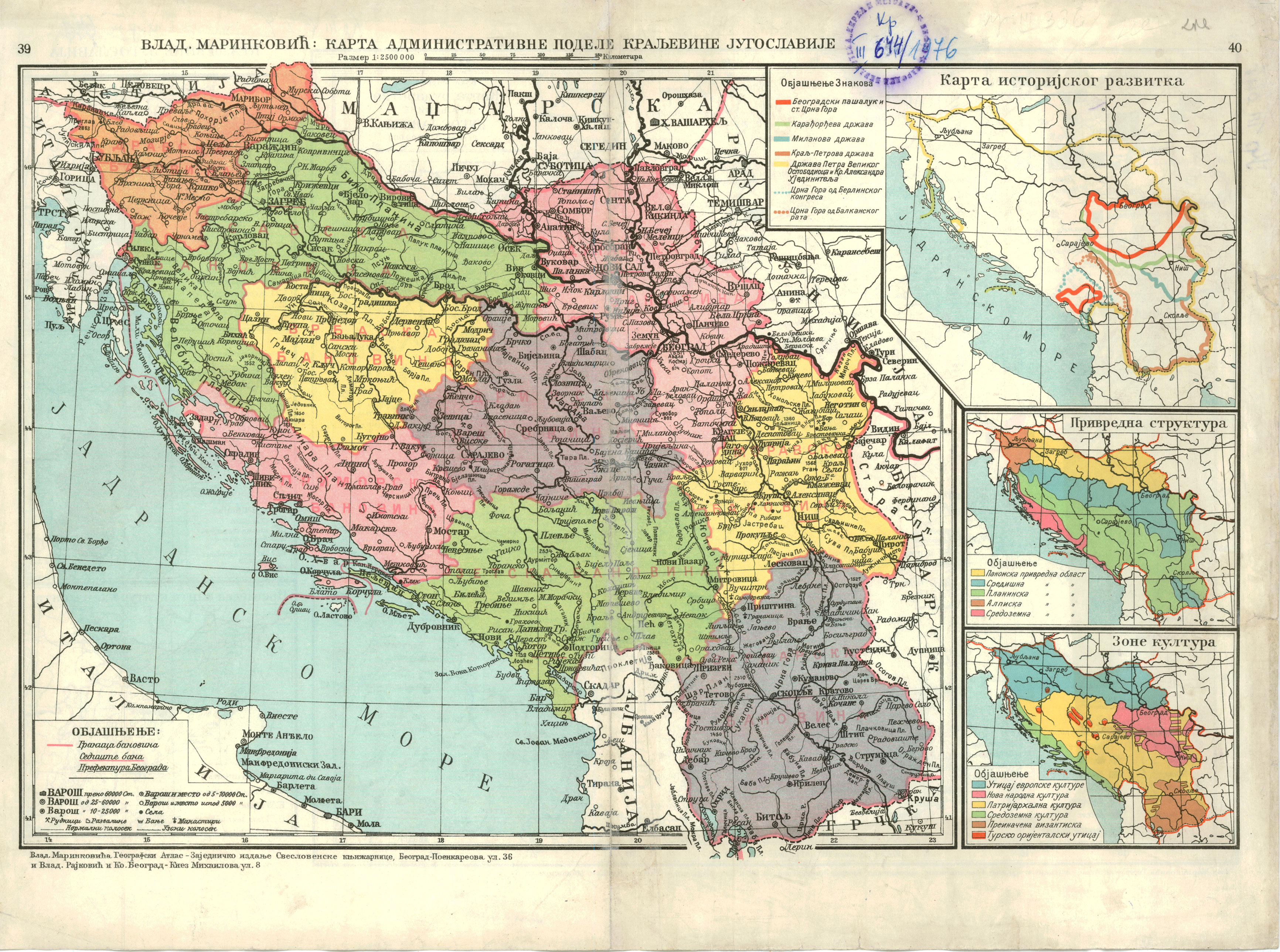
editToday's town and municipality of Donji Vakuf was in 1939 in kotar of Bugojno which that year became part of Banovina Hrvatska. Before that kotar Bugojno was part of Primorska banovina. Whole of Primorska banovina 1939 became part of Ban. Hrvatska. Laz do you have some source which would claim otherways? --Čeha (razgovor) 08:09, 25 November 2009 (UTC)
- Look at this map, http://terkepek.adatbank.transindex.ro/kepek/netre/178.gif . It appears that there is much more land from Jajce to the border. The border on your map is much closer to jajce. (LAz17 (talk) 17:04, 25 November 2009 (UTC)).
- Bigger maps have smaller precision. Look at the positions of the Zenica and Travnik in yours map. They are to close. Livno is a bit eastern that it's true position, and Konjic, Travnik and Fojnica northern. Municipal map is more precise. If Donji Vakuf had been part of Vrbas banovina, than also half of todays municipality of Travnik would have been in Vrbas banovina, as well as half of Zenica and almost whole of Žepče. Don't you have a old Yougoslav geography atlas at home to check this? There the line is pretty much obvious showing that Donji Vakuf was in Banovina Croatia. --Čeha (razgovor) 20:07, 25 November 2009 (UTC)
- Also this [1] is full of errors. Do you see "bansogok hatural" (banate borders) 1931 in Syrmia in the map? That is not correct. That is a line from 1929. The same goes from line near Stolac. Stolac was part of Zetska banovina (1929-1931), but after 1931 is part of Littoral (Primorska) banovina. [2] [3], try to check Donji Vakuf location in those to maps. It is in Littoral (primorska) banovina whole the time. --Čeha (razgovor) 20:13, 25 November 2009 (UTC)
- Until we have a good detailed map we can not use this. Sorry. This map, http://upload.wikimedia.org/wikipedia/en/6/62/Map_of_Banovina_of_Croatia.jpg , is good enough anyways. It shows things nicely. I must admit that I really like it. At any rate, the border clearly goes along a kupres-bugojno-travnik line, barely going away from those towns. As we see, Jajce has more land around it, on the Serb side of the border there. Just use that map, it is good enough. No need to beat a dead horse, as the saying goes. (LAz17 (talk) 21:37, 25 November 2009 (UTC)).
- Laz, that is an nationalistic POV. Straith line goes through Travnik-Donji Vakuf-Kupres which is obvious on my map. I've given you two maps on wich that is clearly visible. If Donji Vakuf were not part of Banovina than there would be hole in that line. Also, let me repeat again, bigger map show things with less precission. Example: On your map Travnik is situated near the banovina line. Kotar travnik in 1939 included todays municipalities of Travnik, Novi Travnik, Vitez and most of Busovača. Whole of kotar was made part of the Banovina Hrvatska Banovina je nastala spajanjem dotadašnje Savske i Primorske banovine, uz dodatak većinski hrvatskih kotareva iz ostalih banovina (Brčko, Derventa, Dubrovnik, Fojnica, Gradačac, Ilok, Šid i Travnik ). Obuhvaćala je površinu od 65.456 km2. [4] and the exact location of town of Travnik can be seen on my map. Now if you do not have some proof showing otherways, please return the map. --Čeha (razgovor) 10:59, 26 November 2009 (UTC)
- Until we have a good detailed map we can not use this. Sorry. This map, http://upload.wikimedia.org/wikipedia/en/6/62/Map_of_Banovina_of_Croatia.jpg , is good enough anyways. It shows things nicely. I must admit that I really like it. At any rate, the border clearly goes along a kupres-bugojno-travnik line, barely going away from those towns. As we see, Jajce has more land around it, on the Serb side of the border there. Just use that map, it is good enough. No need to beat a dead horse, as the saying goes. (LAz17 (talk) 21:37, 25 November 2009 (UTC)).
- The line is not direct, and it encompasses donji vakuf which was not part of the croatian banovina. Simple as that. The area had almost no croats before and after the war. You can not claim that you have the accuracy to produce such a controversial map. At any rate, the maps on here already are good enough. (LAz17 (talk) 17:56, 26 November 2009 (UTC)).
- How the line is not direct? Does it goes 20 kilometers inward and than outward? How does it ethnic percentage of Donji Vakuf area has anything to do with border of Banovina? In southern Kupres there were some Serbian villages, they became part of Banovina. Whole of Primorska (Littoral) banovina became part of Banovina of Croatia. Kotar Bugojno was part of Primorska Banovina. Donji Vakuf municipality was part of kotar Bugojno.
- How the line is not direct? Does it goes 20 kilometers inward and than outward? How does it ethnic percentage of Donji Vakuf area has anything to do with border of Banovina? In southern Kupres there were some Serbian villages, they became part of Banovina. Whole of Primorska (Littoral) banovina became part of Banovina of Croatia. Kotar Bugojno was part of Primorska Banovina. Donji Vakuf municipality was part of kotar Bugojno.
- Also this [1] is full of errors. Do you see "bansogok hatural" (banate borders) 1931 in Syrmia in the map? That is not correct. That is a line from 1929. The same goes from line near Stolac. Stolac was part of Zetska banovina (1929-1931), but after 1931 is part of Littoral (Primorska) banovina. [2] [3], try to check Donji Vakuf location in those to maps. It is in Littoral (primorska) banovina whole the time. --Čeha (razgovor) 20:13, 25 November 2009 (UTC)
- Bigger maps have smaller precision. Look at the positions of the Zenica and Travnik in yours map. They are to close. Livno is a bit eastern that it's true position, and Konjic, Travnik and Fojnica northern. Municipal map is more precise. If Donji Vakuf had been part of Vrbas banovina, than also half of todays municipality of Travnik would have been in Vrbas banovina, as well as half of Zenica and almost whole of Žepče. Don't you have a old Yougoslav geography atlas at home to check this? There the line is pretty much obvious showing that Donji Vakuf was in Banovina Croatia. --Čeha (razgovor) 20:07, 25 November 2009 (UTC)
![[2]](http://www.hervardi.com/images/dravska_savska_banovina_1929_1931.jpg)
![[3]](http://www.hervardi.com/images/dravska_savska_banovina_1931_1939.jpg)
North of kotar Bugojno was kotar Jajce wich included today's municipalities of Jajce,Jezero,Šipovo and Dobretići and which was part of Vrbas Banovina.
Laz, are you really just stalling or you can not go to the city library and take a look ina any of the school atlases from time of second Yugoslavia? In them you'll clearly see that Donji Vakuf was part of Banovina Croatia. --Čeha (razgovor) 23:57, 26 November 2009 (UTC)
RfC: Should File:Banovinas_in_BiH.GIF map be included in article?
edit
- File:Banovinas_in_BiH.GIF, proposed new map by User:Ceha
- File:Map of Banovina of Croatia.jpg, previously used non-free map (will soon be deleted for copyright reasons)
It is a more detailed map of the part of the Banovina area. Čeha (razgovor) 16:00, 26 November 2009 (UTC)
Uninvolved editors comment on RfC
edit- As someone who has some baseline knowledge, but no detailed knowledge, I found that the map does not help me understand where the Banovina of Croatia was in relationship to present-day political boundaries, nor to pre-existing boundaries before its creation. A big part of the problem is that a lot of the surrounding area that would help me recognize the position of these markings is excluded. It's cutting off a lot of the western and northern parts of the Banovina of Croatia, yes? And I don't understand the yellow lines. I think the square is Sarajevo and the circle is Zagreb. But overall, this map just confuses me. MarkNau (talk) 04:57, 17 December 2009 (UTC)
- OK, after a little more looking at it, I understand now that I am looking at present-day Bosnia and Herzegovina, with its internal divisions in yellow. Uh...I guess that means the circle is not Zagreb. Stupid American, I know. But there will be others who do not immediately understand also, and who will be confused by the map. The main point of the article is to inform, and this map does not seem to be trying to do that.MarkNau (talk) 05:15, 17 December 2009 (UTC)
Involved editors discussion
edit- There is no source for the precision that Ceha has claimed in the map. (LAz17 (talk) 17:53, 26 November 2009 (UTC)).
- This is an article about Banovina of Croatia. Present day map of Bosnia and Hercegovina with some color shades which should represent parts of Banovina in todays Bosnia is perhaps for the article about the history of Bosnia, or something.--Ex13 (talk) 19:41, 26 November 2009 (UTC)
- Ex13, where is the problem? This map shows part of banovina Croatia and because of that it should be in gallery. Gallery is a place where maps conected to Banovina should be, no?
- Laz, upper maps are sources, and also; [5] [6] [7] [8] [9], borders of Banovina followed borders of kotars. You can find full list of kotars here [10]. --Čeha (razgovor) 00:20, 27 November 2009 (UTC)
- None of your maps there have donji vakuf included. On top of that, some of them contradict one another. We are dealing with the banovina of croatia, not the other banovinas... and as we can see, the other banovina links contradict one another. Please stop wasting our time. (LAz17 (talk) 01:23, 27 November 2009 (UTC)).
![[5]](http://manjgura.hr/wp-content/uploads/2009/04/kraljevina-jugoslavija-sa-podjelom-na-banovine-1929-god.jpg)
![[6]](http://cro-eu.com/galerija-fotografija/albums/userpics/10001/9-Kraljevina_Jugoslavija_-_podjela_na_banovine_1931.jpg)
![[7]](http://media.photobucket.com/image/banovina%20hrvatska/ignotus1/scan0001.jpg)
![[8]](http://media.photobucket.com/image/banovina%20hrvatska/niko1957/1939b-1000.jpg)
![[9]](http://img132.imageshack.us/img132/360/banovinahrvatskarl6.jpg)
Feuding editors sniping at each other
|
|---|
|
![[11]](http://i459.photobucket.com/albums/qq314/LAzWikiDude/BanovineSadJedGovnaMali.gif)
Admin's comment
edit- I have added some explanative links to the image(s) in question at the top of the RfC section above
- I have also collapsed a part of the discussion above, where LAz17 and Ceha were just exchanging some nastiness. Both users are warned to immediately stop commenting about each other and stop all personal accusations. This discussion will be only about the map, not about editors.
- Everybody is advised that the map that was previously used in this article's infobox (File:Map of Banovina of Croatia.jpg) will have to be deleted soon, because it's non-free and cannot possibly pass for legitimate fair use. (However, I propose keeping it around for a few days just for purposes of discussion, because it may be useful as a source of information for other maps.)
- The following are questions directly to the two editors involved in this dispute. I would ask both of them to give me a direct, concise and matter-of-fact answer. These answers should address only the factual issues about the map in question. When answering, do not comment on the other person or their behaviour, please talk only about the map. Any party who mixes personal accusations, complaints or attacks into it again will be blocked immediately. Fut.Perf. ☼ 20:26, 28 November 2009 (UTC)
Questions to the parties
edit- Question to Ceha
- Please describe fully what sources your map is based on. (List the precise sources, if possible with links, describing what parts of your map each was used for.)
- There seems to be some conflicting evidence about the precise location of those boundaries, e.g. with respect to places like Donji Vakuf and Travnik (see below). What is your opinion about the reason for this conflicting evidence, and what leads to you to favour the information in the sources you used over the information LAz cites below? Fut.Perf. ☼ 20:26, 28 November 2009 (UTC)
- Lets firs sort of the Travnik issue. There were 3 divisions of banovinas:
- 1929. [14]In that year kotar Travnik was part of Littoral (Primorska) Banovina.
- 1931. [15]In that year kotar Travnik was not part of Littoral (Primorska) Banovina (it was part of Drinska Banovina).[16]
- 1939. In that year whole of Littoral (Primorska) Banovina + kotars Travnik and Fojnica entered Banovina Croatia.
- Donji Vakuf was part of Bugojno kotar, and Bugojno Kotar was for the whole time part of Littoral banovina. This is map from 1910 [17] showing Donji Vakuf as part of Bugojno kotar. This is map of 1935 [18] showing Donji Vakuf as part of Bugojno kotar. (P.S. I think that both of this maps have copyright problems and should not be on wikipedia, I think they were previously deleted from here?)
- North of Donji Vakuf is a kotar of Jajce. It is made of towns(municpalities) Jajce, Šipovo, Jezero and Dobretići.
- Borders of those 2 Kotars had not been changed in the period 1929-1939. When borders of banovinas changed they simply added or subtracted a new kotar, not just part of it.--Čeha (razgovor) 11:06, 29 November 2009 (UTC)
- Very nice, Ceha has explained the differences in maps - 1929 vs 1931. At any rate, both my maps clearly show where DV is. (LAz17 (talk) 17:12, 29 November 2009 (UTC)).
- Follow-up question to Ceha: have you got reliable sourcing for these two statements: that D.V. belonged to Bogojno Kotar, and that changes of the Banovinas always affected entire Kotars? I am asking because I cannot see anything clear in this 1935 map you cited as evidence (D.V. and B. both have legends of the same type, and how do you see which of the boundaries are supposed to be Kotar boundaries?); also, this map (probably of the 1929 boundaries) shows the boundary running in between the towns of D.V. and B., and this could be compatible with that (from what I can gather, the boundary appears to cross the river Vrbas very near D.V.; could be on either side of it). So, either these maps are wrong, or D.V. and B. weren't in the same Kotar, or Kotars were sometimes cut up by Banovina divisions after all. Fut.Perf. ☼ 19:19, 29 November 2009 (UTC)
- In [19] scan is a little bit bad, but can't you see doted line south of Jajce? It is where the yellow color stops and the blue one begins. The line also goes through the name of the DonjiVakuf(not to be confused with the town itself). It is unfortunately very low resolution.
- D.V. belonged to Bugojno kotar in 1910 which can be seen in [20] [21].
- I'm pretty much certain that kotar borders haven't changed. I'll try to find some map showing more clearly area borders. --Čeha (razgovor) 01:58, 30 November 2009 (UTC)
![[17]](https://upload.wikimedia.org/wikipedia/commons/4/48/BosniaEthnic1910.jpg)
![[18]](https://upload.wikimedia.org/wikipedia/commons/1/1f/BosniaEthnic1935.jpg)
![[20]](http://storage.canalblog.com/31/13/92110/45756118.jpg)
![[21]](http://storage.canalblog.com/73/67/92110/45756037.png)
- Question to LAz17
- Please state, in as few words as possible, which parts of the map you consider factually incorrect, and on the basis of what other sources you are disputing it. Fut.Perf. ☼ 20:26, 28 November 2009 (UTC)
- Several parts are flawed. The most obvious one is that he is including Donji Vakuf municipality into the map, when in fact it was never part of this entity. Here is evidence that the town was never in the entity.
- Source 1 - http://upload.wikimedia.org/wikipedia/commons/d/d6/Jugoslavija1929_banovine.jpg
- Source 2 - http://i459.photobucket.com/albums/qq314/LAzWikiDude/DonjiVakufSitJedi.gif
- (LAz17 (talk) 21:09, 28 November 2009 (UTC)).
- Thank you. Could you add what source is your second link from, the photobucket snippet? – I see that in both these maps you linked to, there is some boundary that runs just south-east from D.V. However, other than that, the two maps don't agree with each other and the lines shown are quite different (see for instance the location of Travnik, which is shown as part of Drin in the one map but Primorje in the other. How do you explain this – do the two maps mean to show different things (different divisions at different times, perhaps), or is one of them unreliable, or are they both? If at least one of them is unreliable about Travnik, why can we assume they are reliable about D.V.? Fut.Perf. ☼ 21:24, 28 November 2009 (UTC)
- The second image comes from this map, [22]. There seem to be different banovina borders are different times, but I am not sure which one is for when. What I am sure about is that D.V. was always in the Vrbas Banovina. (LAz17 (talk) 22:55, 28 November 2009 (UTC)).
- Thank you. Could you add what source is your second link from, the photobucket snippet? – I see that in both these maps you linked to, there is some boundary that runs just south-east from D.V. However, other than that, the two maps don't agree with each other and the lines shown are quite different (see for instance the location of Travnik, which is shown as part of Drin in the one map but Primorje in the other. How do you explain this – do the two maps mean to show different things (different divisions at different times, perhaps), or is one of them unreliable, or are they both? If at least one of them is unreliable about Travnik, why can we assume they are reliable about D.V.? Fut.Perf. ☼ 21:24, 28 November 2009 (UTC)
Relevance of the map to the Banovina issue
editHere's my 2¢: Why does this map even have to be included in the article? We're talking serious political controversies here. There are many who claim, with significant evidence behind them (the "Brijuni tapes"), that the Croatian wartime president Franjo Tuđman was aiming in the 1990s to reestablish the borders of the Banovina of Croatia through a union with the Croatian Republic of Herzeg-Bosnia, the political entity of the Bosnian Croats (both Croatia and Herzeg-Bonia were ruled by the same party, with Tuđman its president). This map has little or nothing to do with the 1930s political subdivision of the Kingdom of Yugoslavia, as Bosnia did not even exist in its current borders. Now, if this were a map of modern former Yugoslavia with the entire Banovina superimposed it might seem less POV, but this map look like heavy Croatian nationalist nonsense. --DIREKTOR (TALK) 11:42, 29 November 2009 (UTC)
- Director, where is the problem here? Why we should not see which parts of today's Bosnia and Herzegovina were included in Banovina Croatia?
- Territories which were included in Banovina Croatia are now parts of three states: Croatia (most of it), Serbia (middle Syrmia's part) and Bosnia and Herzegovina(Posavina, middle and southwestern Bosnia, western Herzegovina with Neretva valley). What all of this has to do with nationalistic POV? --Čeha (razgovor) 13:57, 29 November 2009 (UTC)
- Well... its my opinion that it is valuable information to see the borders of the Banovina of Croatia over a modern political map, but just having a map that shows what parts of Bosnia were in a Croatia seems to me POV, especially in light of modern events. Could you put together a map of the entire Banovina of Croatia superimposed on modern borders? My point is that this is a map of Bosnia, not of the Banovina. --DIREKTOR (TALK) 14:02, 29 November 2009 (UTC)
- It is a historic map of Bosnia and Herzegovina. Bigger map would not be so detailed. Personally I do not see nothing wrong or POV if showing just a part of Banovina on a separate map. No matter the later events, this is just a history map. --Čeha (razgovor) 15:07, 29 November 2009 (UTC)
- Direktor, after all that we have been through, I believe that we can clearly see Ceha's nationalist bigotry. Here it goes again. What disturbes me the most is that he is claiming this much detail. One thing is to make a map, the other thing is to make a map that has such detail like his proposed map does. But, do not worry, yesterday I figured out how to make a nice map and am currently working on it. (LAz17 (talk) 17:12, 29 November 2009 (UTC)).
- It is a historic map of Bosnia and Herzegovina. Bigger map would not be so detailed. Personally I do not see nothing wrong or POV if showing just a part of Banovina on a separate map. No matter the later events, this is just a history map. --Čeha (razgovor) 15:07, 29 November 2009 (UTC)
- Well... its my opinion that it is valuable information to see the borders of the Banovina of Croatia over a modern political map, but just having a map that shows what parts of Bosnia were in a Croatia seems to me POV, especially in light of modern events. Could you put together a map of the entire Banovina of Croatia superimposed on modern borders? My point is that this is a map of Bosnia, not of the Banovina. --DIREKTOR (TALK) 14:02, 29 November 2009 (UTC)
- Just my personal opinion as an outside reader here: I wouldn't worry too much about such subtle POV implications – maybe you insiders to the conflict are a bit over-sensitive there (understandably), but the rest of our readership really won't care, won't know, and won't want to know. But what we outsiders do need is some visual reference frame to relate those boundary lines too: the coastlines, the modern national boundaries, some major rivers, and the major towns. And you need the context of not just Bosnia, but also the surroundings. Otherwise, such a map is totally opaque – for instance, the reader will have no idea why there are two spots marked as "Croatian". We wouldn't know that they are connected on the outside. Please remember we stupid ignorant foreigners need these trivial background things. Fut.Perf. ☼ 19:33, 29 November 2009 (UTC)
- Silence you ignorant foreigner! xD Lol that is so wrong... Somehow I sense people from around here are more ignorant on the whole than the foreigners, but that's me. I get your point, but no need to "praise" us with such phrases, Future ;). Heh, you're (obviously) not "stupid" or "ignorant" if you don't know anything about this godforsaken place, and we're obviously not especially "knowledgeable" simply because we know our own history. --DIREKTOR (TALK) 01:42, 30 November 2009 (UTC)
- :) Well, to my experiance FPaS have never been ignorant, and always willing to listen and offer sound dialogue :) Nevermind that, his remark stands (additional information are probably welcomed). Should I add inscriptions "Banovina Croatia" to the north and west of the map? That would make things clearer ? --Čeha (razgovor) 01:58, 30 November 2009 (UTC)
- Ah, more praise. :) This time for our venerable admin. Aren't we all selfless today. Seriously though, Ceha, could you possibly create a larger map of the Banovina of Croatia and superimpose it on modern borders? With one stroke we would end all dispute about the details and notability. Just asking if that's a possibility? --DIREKTOR (TALK) 03:05, 30 November 2009 (UTC)
- Yes and no :) I can not duplicate BiH municipal grid on an larger map. I could copy this map [23]
- and in one color show territories of Banovina which are now part of Republic of Croatia, in another color which are now part of Bosnia and Herzegovina and in another which are now part of Serbia. I do not know what to do with territories which are now part of Republic of Croatia and wich were not part of Banovina (Istra, Rijeka, Zadar, some islands, Baranja). Should it be shown on the map? Problem is that a lot of that territories is near the sea and if not shown (like Zadar or Rijeka for example) it would look like it just had higher level of sea shore :)
- What do you think? And which colors should be used for this ?--Čeha (razgovor) 09:18, 30 November 2009 (UTC)
- Ah, more praise. :) This time for our venerable admin. Aren't we all selfless today. Seriously though, Ceha, could you possibly create a larger map of the Banovina of Croatia and superimpose it on modern borders? With one stroke we would end all dispute about the details and notability. Just asking if that's a possibility? --DIREKTOR (TALK) 03:05, 30 November 2009 (UTC)
- :) Well, to my experiance FPaS have never been ignorant, and always willing to listen and offer sound dialogue :) Nevermind that, his remark stands (additional information are probably welcomed). Should I add inscriptions "Banovina Croatia" to the north and west of the map? That would make things clearer ? --Čeha (razgovor) 01:58, 30 November 2009 (UTC)
- Silence you ignorant foreigner! xD Lol that is so wrong... Somehow I sense people from around here are more ignorant on the whole than the foreigners, but that's me. I get your point, but no need to "praise" us with such phrases, Future ;). Heh, you're (obviously) not "stupid" or "ignorant" if you don't know anything about this godforsaken place, and we're obviously not especially "knowledgeable" simply because we know our own history. --DIREKTOR (TALK) 01:42, 30 November 2009 (UTC)
![[23]](https://en.wikipedia.org/wiki/File:Croatian_shto_dialects_in_Cro_and_BiH.PNG)

- Something like this [24] ? --Čeha (razgovor) 09:29, 1 December 2009 (UTC)
- Hmm, just my personal opinion again, honestly, I find these colors rather confusing. If you have two logical "layers" to display together (historical and modern territories), I think the best way is to use solid coloured areas only for one of them, and contour lines for the other. Why don't you try thin dark lines for the modern boundaries, overlaid on a single coloured area for the historical banovina? Or, you could then even add another component by having slightly different colours for the different parts from which the banovina was composed (former Primorska, former Savska, and those additional districts). If I may make another suggestion, I think you should check out Wikipedia:WikiProject Maps/Conventions, about what types of colours to use. It looks a lot more professional if it sticks to a Wikipedia-wide coloring scheme. Fut.Perf. ☼ 10:34, 1 December 2009 (UTC)
- FpaS, thanks for the link[25], it shall be very usefull. Hower, I do have a problem. I do not have a costline or border from in the base image under which I made the map. That is the main reason why I did not use contour lines :(
- I'll put two other maps (one without second layer and other with Savska, Primorska and additional districts). --Čeha (razgovor) 15:53, 1 December 2009 (UTC)
- 2 maps are here [26], [27]. What do you think? --Čeha (razgovor) 16:33, 1 December 2009 (UTC)
- Hmm, just my personal opinion again, honestly, I find these colors rather confusing. If you have two logical "layers" to display together (historical and modern territories), I think the best way is to use solid coloured areas only for one of them, and contour lines for the other. Why don't you try thin dark lines for the modern boundaries, overlaid on a single coloured area for the historical banovina? Or, you could then even add another component by having slightly different colours for the different parts from which the banovina was composed (former Primorska, former Savska, and those additional districts). If I may make another suggestion, I think you should check out Wikipedia:WikiProject Maps/Conventions, about what types of colours to use. It looks a lot more professional if it sticks to a Wikipedia-wide coloring scheme. Fut.Perf. ☼ 10:34, 1 December 2009 (UTC)
- Something like this [24] ? --Čeha (razgovor) 09:29, 1 December 2009 (UTC)
![[24]](https://commons.wikimedia.org/wiki/File:Banovina.png)
![[26]](https://commons.wikimedia.org/wiki/File:Division_of_banovina.png)
![[27]](https://commons.wikimedia.org/wiki/File:Creation_of_Banovina.png)
Could you please make a map of Banovina without mixing up present-day maps and historical maps? --Ex13 (talk) 12:05, 1 December 2009 (UTC)
- I have a problem with base map (as explained in upper discussion). If you can give me some base map with wich I could work on (countour lines etc.) I can make another map. --Čeha (razgovor) 15:53, 1 December 2009 (UTC)
- If you can wait a few days, I might be able to provide a simple contour base map with the coast lines and modern borders. Fut.Perf. ☼ 18:35, 1 December 2009 (UTC)
- If you like, check out File:Yugoslavia topographic base map.svg, which I just uploaded. It needs a bit of work to become a fully useful topographic map, but you can use just the coastline and boundary parts alone. If you open it in an SVG editor, you can separate the topographic bitmap and the vectorised line drawings, and cut out what you need for your purposes. Fut.Perf. ☼ 01:19, 2 December 2009 (UTC)
- I haven't work with svg editor (yet:). All of this map were made with basic paintbrush :) I'll see what can I make with it. Thanks :) --Čeha (razgovor) 12:51, 2 December 2009 (UTC)
- If you like, check out File:Yugoslavia topographic base map.svg, which I just uploaded. It needs a bit of work to become a fully useful topographic map, but you can use just the coastline and boundary parts alone. If you open it in an SVG editor, you can separate the topographic bitmap and the vectorised line drawings, and cut out what you need for your purposes. Fut.Perf. ☼ 01:19, 2 December 2009 (UTC)
- If you can wait a few days, I might be able to provide a simple contour base map with the coast lines and modern borders. Fut.Perf. ☼ 18:35, 1 December 2009 (UTC)
- In case you have not noticed, Ceha has quietly ignored the Donji Vakuf problem. His borderline around there clearly shows an over-representation of land. Also, there is this map, [28]. (LAz17 (talk) 14:37, 2 December 2009 (UTC)).
- Well, this map [29] really does not say anything about D.V. Border of the banovina is inprecise (it doesn't follows the outline of Savska and Primorska banovinas, it takes a part of Hungary and Italy). Moreover it shows that D.V. was in Primorska banovina (and whole of Primorska banovina entered Banovina Croatia).
- For now, I think that a D.V. should stand be shown as part of B.C. (but this is my POV). If a consensus is reached at the end of the discussion that it should not be there, I'll put it out. Deal? --Čeha (razgovor) 15:18, 2 December 2009 (UTC)
- I would agree that File:Kartashs.jpg appears to be imprecise. The way the dark red border line of the Hrvatska banovina relates to the near-parallel boundaries of the underlying areas of the older banovinas, as shown in that map, it looks pretty much as if two maps of different mathematical projections were just mechanically overlaid without the necessary graphical corrections. (So, Hrvatska lost a narrow parallel strip of land to Vrbaska all along its northern boundary, but at the same time gained just such a parallel strip of land from Zetska all along its south-eastern boundary? That's quite implausible, especially since we have textual references to the legislative acts establishing Hrvatska, which -- if I understood correctly -- seem to say Primorska in its old boundaries was just made part of Hrvatska in toto.) BTW, that map too is a copyright problem and will be deleted. Fut.Perf. ☼ 15:53, 2 December 2009 (UTC)
- FPaS, I have given you some maps that show that donji vakuf is was not in banovina hrvatska. To this ceha had no reply. What do we do now? Can you help mediate when he prefers to disregard sources? Also, I can give additional sources that show that Bugojno was at the very border, so thus by logic nothing north such as DV couldh ave been in the banovina of croatia. (LAz17 (talk) 17:06, 2 December 2009 (UTC)).
- My impression right now is that virtually all these maps are just too imprecise to be useful for this kind of determination. All these maps that pretend to show the same thing differ from each other. Just compare your own map and its models with File:Kartashs.jpg -- the shapes of those boundary lines are wildly different. No two maps I've seen seem to agree with each other. The differences between them in these parts of the border are large enough to cast doubt on any claim derived from any of them, with respect to the location of any individual small place. Under these circumstances, I find Ceha's approach, of seeking information from textual sources and knowledge of the underlying small-scale administrative structure, rather than just from other maps, to be quite reasonable. Fut.Perf. ☼ 17:19, 2 December 2009 (UTC)
- An excellent observation, that Ceha can not claim the level of detail that his initial map claimed. This is what I have been trying to get across all thing time. I do not think that there is a small-scale administrative structure source available anywhere. I might be wrong, of course. The best thing that I can come up with is maps that seem to be pretty accurate of the borders before the banovina of croatia. Naturally DV is shown as not part of it. I think the best thing to do is to move forward that way. (LAz17 (talk) 17:27, 2 December 2009 (UTC)).
- I'm not sure you got my point. If the maps are imprecise, then your claim that DV was outside the border hangs in the air just as much as Ceha's claim that it was inside. However, Ceha also has a plausible story to support his conjecture, on the basis of his knowledge of the administrative structure on kotar level and the legislative texts describing the restructuring. Let me put it like this: if we follow Ceha's story and assume the border followed those kotar boundaries, then the conflicting evidence from the other maps can still be explained as being just distorted/imprecise versions of what was in reality the line Ceha proposes. The differences between Ceha's line and any of the lines in the printed maps are not larger than the differences that exist among those other lines anyway. Which means we can just as well use Ceha's reconstruction, as being at least a plausible guess, since no other line has any realistic claim to being more reliable than that. Fut.Perf. ☼ 18:04, 2 December 2009 (UTC)
- Map 1, [30]
- Map 2, []
- Map 3, [31] on here you can see that donji vakuf is farther north/northwest from bugojno.
- More, [32] [33] [34] shows that bogujno was on the very border of banovina hrvatska as other maps shows,
- [35] Municipalities of Banovina Hrvatska - we can see that the bogujno municipality is missing that "top part" that it had previously - that is donji vakuf gone.
- And lastly this, Ceha's old work that should be deleted. [36] You can literally tell that he was not sure what color to put donji vakuf as. That is why donji vakuf is a different color compared to the surroundings.
- All this should be enough evidence for us to be certain that bugojno was not in banovina hrvatska. No map that shows cities includes it in banovina hrvatska. It just doesn't. Putting it in would be nationalist POV. And quite frankly I do not see why it would be hard to believe that a Croat wants to portray former borders as being bigger- this a common occurrence, though most such people do not have the courage to have a wiki account - they just vandalize from IPs. (LAz17 (talk) 20:55, 2 December 2009 (UTC)).
- I'm not sure you got my point. If the maps are imprecise, then your claim that DV was outside the border hangs in the air just as much as Ceha's claim that it was inside. However, Ceha also has a plausible story to support his conjecture, on the basis of his knowledge of the administrative structure on kotar level and the legislative texts describing the restructuring. Let me put it like this: if we follow Ceha's story and assume the border followed those kotar boundaries, then the conflicting evidence from the other maps can still be explained as being just distorted/imprecise versions of what was in reality the line Ceha proposes. The differences between Ceha's line and any of the lines in the printed maps are not larger than the differences that exist among those other lines anyway. Which means we can just as well use Ceha's reconstruction, as being at least a plausible guess, since no other line has any realistic claim to being more reliable than that. Fut.Perf. ☼ 18:04, 2 December 2009 (UTC)
- An excellent observation, that Ceha can not claim the level of detail that his initial map claimed. This is what I have been trying to get across all thing time. I do not think that there is a small-scale administrative structure source available anywhere. I might be wrong, of course. The best thing that I can come up with is maps that seem to be pretty accurate of the borders before the banovina of croatia. Naturally DV is shown as not part of it. I think the best thing to do is to move forward that way. (LAz17 (talk) 17:27, 2 December 2009 (UTC)).
- My impression right now is that virtually all these maps are just too imprecise to be useful for this kind of determination. All these maps that pretend to show the same thing differ from each other. Just compare your own map and its models with File:Kartashs.jpg -- the shapes of those boundary lines are wildly different. No two maps I've seen seem to agree with each other. The differences between them in these parts of the border are large enough to cast doubt on any claim derived from any of them, with respect to the location of any individual small place. Under these circumstances, I find Ceha's approach, of seeking information from textual sources and knowledge of the underlying small-scale administrative structure, rather than just from other maps, to be quite reasonable. Fut.Perf. ☼ 17:19, 2 December 2009 (UTC)
- FPaS, I have given you some maps that show that donji vakuf is was not in banovina hrvatska. To this ceha had no reply. What do we do now? Can you help mediate when he prefers to disregard sources? Also, I can give additional sources that show that Bugojno was at the very border, so thus by logic nothing north such as DV couldh ave been in the banovina of croatia. (LAz17 (talk) 17:06, 2 December 2009 (UTC)).
- I would agree that File:Kartashs.jpg appears to be imprecise. The way the dark red border line of the Hrvatska banovina relates to the near-parallel boundaries of the underlying areas of the older banovinas, as shown in that map, it looks pretty much as if two maps of different mathematical projections were just mechanically overlaid without the necessary graphical corrections. (So, Hrvatska lost a narrow parallel strip of land to Vrbaska all along its northern boundary, but at the same time gained just such a parallel strip of land from Zetska all along its south-eastern boundary? That's quite implausible, especially since we have textual references to the legislative acts establishing Hrvatska, which -- if I understood correctly -- seem to say Primorska in its old boundaries was just made part of Hrvatska in toto.) BTW, that map too is a copyright problem and will be deleted. Fut.Perf. ☼ 15:53, 2 December 2009 (UTC)
![[28]](https://commons.wikimedia.org/wiki/File:Kartashs.jpg)
![[32]](http://www.hercegbosna.org/images/banovina.jpg)
![[33]](http://cro-eu.com/galerija-fotografija/albums/userpics/10001/10-Banovina_Hrvatska.jpg)
![[35]](http://i220.photobucket.com/albums/dd307/ignotus1/scan0001.jpg?t=1259786535)
![[36]](https://en.wikipedia.org/wiki/File:Banovina_H.GIF)
File:BanHrvatska1939.gif - this is also incorrect map because on that map islands is missing --Ex13 (talk) 15:29, 2 December 2009 (UTC)
- I can add more islands. Tell me which ones your want added. Keep in mind that the smallest of the islands are not necessary. I think I included most major ones. Let me know what else you want. (LAz17 (talk) 17:06, 2 December 2009 (UTC)).
More data, qu to Ceha
editI just found the following: According to the text cited at hr:Primorska banovina, the border of the 1931 Primorska Banovina went through the meeting point of the three districts of Jajce, Bugojna and Travnik, which was defined by a peak called Rakovce ("sjecišta međa triju okruga: Jajca, Bugojna i Travnika (Rakovce, brdo 1217)"). According to [37], a peak under that name does indeed exist, at 44°11′10″N 17°28′23″E / 44.186°N 17.473°E [38]. It is located some 8km NE of Donji Vakuf, and 15km N of the town of Bugojno. If you compare this with the district boundaries shown in Ceha's 1910 map [39], one can see that the 1931 district boundaries must have differed: in the 1910 map, the meeting point between the three districts is almost due north of D.V., and much further away from Bugojno. The Rakovce location would probably correspond roughly to the corner of the small red area in between D.V. and Travnik in the 1910 map. – So, we still don't know where the boundary ran from the Rakovce point (towards the SW), but we do know it didn't run as far north as the 1910 district division. – Ceha, would you accept that this finding points towards the possibility that D.V. was on the Jajce side of the border in 1931 (and, by extension, in 1939)? Fut.Perf. ☼ 23:04, 2 December 2009 (UTC)
- This does opens a new possibility. The point is nearer to D.V. Than it is it to Jajce, and in 1910 the border of the kotars was in the middle. It would have realy seem that the borders of kotars changed, and that at least northern part of D.V municipality went into Jajce kotar (some part of it was in the Bugojno kotar).
- [40] Rakovce is here. Here is the municipal area map [41]. Border between Jajce, Donji Vakuf and Travnik is in near Svrzinac. Rakovce is near Komar, and I gues it should be near Gredina? Bottom lime, it seems I made a mistake (at least in northern municipal part of Donji Vakuf). Sorry. --Čeha (razgovor) 09:37, 3 December 2009 (UTC)
- Nice to see that I am correct again, and Ceha as usual wrong. Discussion is over, but I ran into two interesting maps, so I figure on posting them here because I like how much detail they show.
- (LAz17 (talk) 18:45, 3 December 2009 (UTC)).
- The point of wikipedia is not right or wrong, nor is this the place to wage some quasi wars. At least it should be. No insulting, but pure data.
- Laz, the map is corrected if you think it is ok, return it to the article.--Čeha (razgovor) 08:11, 4 December 2009 (UTC)
- Ceha, so much of what you put on wikipedia is plainly false. And you vigorously defend your false information. It's really a shame.
- I am not putting your map back as it claims to have accuracy that can not be confirmed. Borders change over time. Sorry man. And, don't tell me to do things, please. (LAz17 (talk) 17:28, 4 December 2009 (UTC)).
- Borders of Bugojno kotar where the same in 1910 and 1953. There is also one book which shows D.V. as part of Bugojno kotar in 1935 [44] which, you laz uploaded. Similar maps are shown in much of the litterature from that time. If I made an error I made it in good faith. And this Ceha, so much of what you put on wikipedia is plainly false. is a libel.
- If you do not have any data of changes of borders of Travnik,Fojnica, Livno, Konjic, Mostar, Stolac or Čapljina kotars then return the map back. Map is pretty much sourced (here is a dozen of maps which source it) so if you will not return it, I'll will. I'll just remind you that puting out sourced matterial is considered vandalism. --Čeha (razgovor) 16:43, 7 December 2009 (UTC)
- Your stuff was not sourced. It was problematic. You still claim a level of precision that can not be claimed. I have nothing more to add. (LAz17 (talk) 04:21, 8 December 2009 (UTC)).
- Nor prove the contrary. There is a great map from 1910. If you find any of the changes, I'll change it back. Future, what do you think? --Čeha (razgovor) 11:00, 8 December 2009 (UTC)
- Your stuff was not sourced. It was problematic. You still claim a level of precision that can not be claimed. I have nothing more to add. (LAz17 (talk) 04:21, 8 December 2009 (UTC)).
![[41]](http://img38.imageshack.us/img38/2019/donjivakufresize.jpg)
![[42]](https://sr.wikipedia.org/wiki/%D0%A1%D0%BB%D0%B8%D0%BA%D0%B0:Vrbaskabanovina.jpg)
![[43]](https://sr.wikipedia.org/wiki/%D0%A1%D0%BB%D0%B8%D0%BA%D0%B0:Primorskabanovina.jpg)
New map by LAz17
edit
User:LAz17 has created this new proposed map of the banovina, uploaded on Commons. I'd encourage editors to check it out and place it in the article if they so wish. (Due to the topic ban, LAz won't be able to discuss the map here, but he is of course welcome to continue working on Commons, and everybody here is welcome to use his work.) I hope there won't be new contention over this, will there? Fut.Perf. ☼ 18:35, 16 December 2009 (UTC)
- He's basically cleaned up the crummy map that I added several years ago. The font is rather small to be of much use except at a very large scale.--Thewanderer (talk) 21:10, 16 December 2009 (UTC)
Nationalist edit-warring
edit- The language of the unitary Kingdom of Yugoslavia in all its provinces was Serbo-Croatian or "Serbo-Croato-Slovene", both alphabets were in use throughout (actually primarily Cyrillic). Present sources confirming that the Banovina of Croatia province (which housed a very large Serbian population) is an exception, or stop vandalizing the article.
- Using the civil flag as opposed to the state flag (per standard usage, and per the Kingdom of Yugoslavia article among others). Sources are very abundant regarding that flag being the civil flag. --DIREKTOR (TALK) 17:20, 16 July 2010 (UTC)
Civil vs state flag
editThe image File:Civil Flag of Banovina of Croatia.svg, was the civil flag of the Banovina of Croatia. As is obvious from numerous sources, this was the principal flag of the Banovina. The flag of the Kingdom of Yugoslavia did not sport any device, and neither did a flag of its province.
- Ehrlich Zdvořák, Janko (2001-08-29) Croatian Bannate in Yugoslavia (1939-1941), Flags of the World website – flagspot.net, Last modified: 2004-10-23, Retrieved: 2010-01-25
- Luchtenberg, Mello. Flag history : Croatia in Yugoslavia periods : 1939-1941, Vexilla-mundi.com, Leeuwarden (Frisia, NL), Retrieved: 2010-01-25
- Ehrlich Zdvořák, Janko. Bannate of Croatia (1939 – 1941), miyeonjan.tripod.com, Zagreb, Last modified: 2002-05-10, Retrieved: 2010-01-25
- Luchtenberg, Mello. Croatia : Color recommendations, Vexilla-mundi.com, Leeuwarden (Frisia, NL), Retrieved: 2010-01-25
The checkerboard version was an alternate version used roughly as a state flag. The civil flag was primary, just as with the flag of the whole country, more frequently used by the population, and generally takes precedence. "Flag was simple tricolour red-white-blue." --DIREKTOR (TALK) 00:17, 9 August 2010 (UTC)
timeline/events in the infobox
editThe infobox seems to be excessively legalistic - the Banovina effectively ceased to exist together with the Kingdom in 1941. --Joy [shallot] (talk) 10:33, 1 June 2014 (UTC)
External links modified
editHello fellow Wikipedians,
I have just modified one external link on Banovina of Croatia. Please take a moment to review my edit. If you have any questions, or need the bot to ignore the links, or the page altogether, please visit this simple FaQ for additional information. I made the following changes:
- Added
{{dead link}}tag to http://www.sssbjt.hr/hpm/p0260003.htm - Added archive https://web.archive.org/web/20090813094638/http://www.vk-jadran.hr:80/Povijest/Kronologija%20hrvatskog%20veslanja.html to http://www.vk-jadran.hr/Povijest/Kronologija%20hrvatskog%20veslanja.html
- Added
{{dead link}}tag to http://www.vjesnik.hr/pdf/2000%5C12%5C05%5C18A18.PDF
When you have finished reviewing my changes, please set the checked parameter below to true or failed to let others know (documentation at {{Sourcecheck}}).
This message was posted before February 2018. After February 2018, "External links modified" talk page sections are no longer generated or monitored by InternetArchiveBot. No special action is required regarding these talk page notices, other than regular verification using the archive tool instructions below. Editors have permission to delete these "External links modified" talk page sections if they want to de-clutter talk pages, but see the RfC before doing mass systematic removals. This message is updated dynamically through the template {{source check}} (last update: 5 June 2024).
- If you have discovered URLs which were erroneously considered dead by the bot, you can report them with this tool.
- If you found an error with any archives or the URLs themselves, you can fix them with this tool.
Cheers.—InternetArchiveBot (Report bug) 10:13, 25 October 2016 (UTC)
External links modified
editHello fellow Wikipedians,
I have just modified one external link on Banovina of Croatia. Please take a moment to review my edit. If you have any questions, or need the bot to ignore the links, or the page altogether, please visit this simple FaQ for additional information. I made the following changes:
- Added archive https://web.archive.org/web/20130531223820/http://www.hockeyslovakia.sk/sk/clanok/prehlad-zapasov-a-timu-sr-od-roku-1940 to http://www.hockeyslovakia.sk/sk/clanok/prehlad-zapasov-a-timu-sr-od-roku-1940
When you have finished reviewing my changes, you may follow the instructions on the template below to fix any issues with the URLs.
This message was posted before February 2018. After February 2018, "External links modified" talk page sections are no longer generated or monitored by InternetArchiveBot. No special action is required regarding these talk page notices, other than regular verification using the archive tool instructions below. Editors have permission to delete these "External links modified" talk page sections if they want to de-clutter talk pages, but see the RfC before doing mass systematic removals. This message is updated dynamically through the template {{source check}} (last update: 5 June 2024).
- If you have discovered URLs which were erroneously considered dead by the bot, you can report them with this tool.
- If you found an error with any archives or the URLs themselves, you can fix them with this tool.
Cheers.—InternetArchiveBot (Report bug) 17:51, 14 July 2017 (UTC)