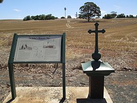
St Johns is a locality southeast of Kapunda in the northern Barossa Valley, South Australia. Originally a private subdivision on sections 1450, 1451 and 1533 of the Hundred of Belvidere,[2] the boundaries of the locality were formalised in 2000 and the name formally adopted based on long-established use.[3]
| St Johns South Australia | |||||||||||||||
|---|---|---|---|---|---|---|---|---|---|---|---|---|---|---|---|
 View towards the former church and reformatory from the cemetery | |||||||||||||||
| Coordinates | 34°21′46″S 138°57′34″E / 34.36278°S 138.95944°E | ||||||||||||||
| Population | 8 (SAL 2021)[1] | ||||||||||||||
| Postcode(s) | 5373 | ||||||||||||||
| LGA(s) | Light Regional Council | ||||||||||||||
| State electorate(s) | Stuart | ||||||||||||||
| Federal division(s) | Barker | ||||||||||||||
| |||||||||||||||
The foundation stone for the St John the Evangelist church was laid on 2 April 1850, however the building was not completed until 30 April 1854. A school was opened in 1859, run by the Sisters of St Joseph of the Sacred Heart after 1868. From 1897, the school became a reformatory for girls until it closed in 1909.[4]
References edit
- ^ Australian Bureau of Statistics (28 June 2022). "St Johns (suburb and locality)". Australian Census 2021 QuickStats. Retrieved 28 June 2022.
- ^ "Plan of Hundred of Belvidere, County of Light, South Australia" (Map). Hundred of Belvidere. Hundred of Belvidere, County of Light: State Library of South Australia. 1899. Retrieved 1 December 2017.
- ^ "Property Location Browser (Search: St Johns, LOCB)". Government of South Australia. Retrieved 5 February 2016.
- ^ "St John's, Johnstown, Kapunda". Flinders Ranges Research. Retrieved 9 February 2016.
