Spurn is a narrow sand tidal island[1] located off the tip of the coast of the East Riding of Yorkshire, England that reaches into the North Sea and forms the north bank of the mouth of the Humber Estuary. It was a spit with a semi-permanent connection to the mainland, but a storm in 2013 made the road down to the end of Spurn impassable to vehicles at high tide.[2]
| Spurn | |
|---|---|
 Spurn in May 2005, showing the lighthouse and sand-dunes. | |
 Spurn Location within the East Riding of Yorkshire | |
| Population | 50 (approx) |
| OS grid reference | TA399108 |
| Civil parish | |
| Unitary authority | |
| Ceremonial county | |
| Region | |
| Country | England |
| Sovereign state | United Kingdom |
| Post town | HULL |
| Postcode district | HU12 |
| Dialling code | 01964 |
| Police | Humberside |
| Fire | Humberside |
| Ambulance | Yorkshire |
| UK Parliament | |
The island is over three miles (five kilometres) long, almost half the width of the estuary at that point, and as little as 50 yards (45 metres) wide in places. The southernmost tip is known as Spurn Head or Spurn Point and was, until early 2023, the home to an RNLI lifeboat station and two disused lighthouses.[3] It forms part of the civil parish of Easington.
Spurn Head covers 280 acres (113 hectares) above high water and 450 acres (181 hectares) of foreshore. It has been owned since 1960 by the Yorkshire Wildlife Trust and is a designated national nature reserve, heritage coast and is part of the Humber Flats, Marshes and Coast Special Protection Area.
History
edit
Spurn Head was known to classical authors, such as Ptolemy as Ocelum Promontorium (Ancient Greek: Ὀκέλον ἄκρον).[4][5] In the Middle Ages, Spurn Head was home to the port of Ravenspurn (a.k.a. Ravenspur or Ravensburgh), where Henry of Bolingbroke landed in 1399 on his return to dethrone Richard II. It was also where Sir Martin de la See led the local resistance against Edward IV's landing on 14 March 1471, as he was returning from his six months' exile in the Netherlands.[6] An earlier village, closer to the point of Spurn Head, was Ravenser Odd. Along with many other villages on the Holderness coast, Ravenspurn and Ravenser Odd were lost to the encroachments of the sea, as Spurn Head, due to erosion and deposition of its sand, migrated westward.[7]

The lifeboat station at Spurn Head was built in 1810. Owing to the remote location, houses for the lifeboat crew and their families were added a few years later. By the 1870s a room in the high lighthouse was being used as a chapel for the small residential community on Spurn Head, serving 'the keepers, coast-guardsmen and fishermen who live at the Point'.[8]

During the First World War two coastal artillery 9.2-inch (230 mm) batteries were added at either end of Spurn Head, with 4-and-4.7-inch (100 and 120 mm) quick-firing guns in between. The emplacements can be clearly seen, and the northern ones are particularly interesting as coastal erosion has partly toppled them onto the beach, revealing the size of the concrete foundations very well.
As well as a road, the peninsula also used to have a railway, parts of which can still be seen. Unusual 'sail bogies' were used as well as more conventional light railway equipment.[9]
Following a tidal surge in December 2013 the roadway became unsafe, and access to Spurn Point is on foot only, with a warning not to attempt this when exceptionally high tides are due.[10][11] Spurn has now become a tidal island, as the narrowest part of the sandbank connection to the mainland is flooded with each high tide.[12]
Plans to build a new visitor centre for the reserve were unveiled in September 2014 by Yorkshire Wildlife Trust (YWT).[13][14] Planning consent for the initial plans was refused by East Riding of Yorkshire Council in July 2016[15] but revised plans were approved in January 2017.[16] These plans face local opposition because of the perceived feeling of commercialisation of the reserve by YWT, with plans to build extensive car park facilities, no longer free.[17] The new visitor centre was officially opened by Simon King on 20 March 2018.[18]
A February 2023 inspection of the RNLI launch jetty revealed structural issues, as a result the station was moved to Grimsby.[19]
Geography
edit
The spit is made up from sand, shingle and boulder clay eroded from the Holderness coastline washed down the coastline from Flamborough Head. Material is washed down the coast by longshore drift and accumulates to form the long, narrow embankment in the sheltered waters inside the mouth of the Humber Estuary. It is maintained by plants, especially marram grass (Ammophila arenaria). Waves carry material along the peninsula to the tip, continually extending it; as this action stretches the peninsula it also narrows it to the extent that the sea can cut across it in severe weather. When the sea cuts across it permanently, everything beyond the breach is swept away, only to eventually reform as a new spit pointing further south. This cycle of destruction and reconstruction occurs approximately every 250 years. More recently, Dr. John Pethick of Hull University put forward a different theory to explain the formation of Spurn Head. He suggests that the spit head has been a permanent feature since the end of the last ice age, having developed on an underwater glacial moraine. As the ice sheets melted, sea level gradually rose and longshore drift caused a spit to form between this and other islands along the moraine. Under normal circumstances, the sea washes over the neck of the spit taking sand from the seaward side and redepositing it on the landward side. Over time, the whole spit, length intact, slips back – with the spit-head remaining on its glacial foundation. This process has now been affected by the protection of the spit put in place during the Victorian era. This protection halted the wash-over process and resulted in the spit being even more exposed due to the rest of the coast moving back 110 yards (100 metres) since the 'protection' was constructed. The now crumbling defences will not be replaced and the spit will continue to move westwards at a rate of 6 feet 7 inches (2 metres) per year, keeping pace with the coastal erosion further north.
The second of the Six Studies in English Folk Song composed in 1926 by Ralph Vaughan Williams, the Andante sostenuto in E flat "Spurn Point" celebrates this peninsula.
It was featured on the television programme Seven Natural Wonders as one of the wonders of Yorkshire.
Ecology
editThe landward-side mud flats are an important feeding ground for wading birds, and the area has a bird observatory, for monitoring migrating birds and providing accommodation to visiting birdwatchers. Their migration is assisted by east winds in autumn, resulting in drift migration of Scandinavian migrants, sometimes leading to a spectacular "fall" of thousands of birds. Many uncommon species have been sighted there, including a cliff swallow from North America, a lanceolated warbler from Siberia and a black-browed albatross from the Southern Ocean. More commonly, birds such as northern wheatears, whinchats, common redstarts and flycatchers alight at Spurn on their way between breeding and wintering grounds elsewhere. When the wind is in the right direction migrants are funnelled down Spurn Point and are counted at the Narrows Watchpoint, more than 15,000 birds can fly past on a good morning in autumn with 3,000 quite normal.
Lighthouses
edit Spurn Point | |
 | |
| Location | Spurn Point East Riding of Yorkshire England |
|---|---|
| OS grid | TA4034511239 |
| Coordinates | 53°34′44″N 0°07′06″E / 53.578996°N 0.118325°E |
| Tower | |
| Constructed | 1895 |
| Designed by | Thomas Matthews |
| Construction | brick tower |
| Automated | 1957 |
| Height | 128 ft (39 m) |
| Shape | cylindrical tower with balcony and lantern |
| Markings | white and black bands tower, white lantern |
| Operator | Spurn Point National Nature Reserve[20] |
| Heritage | Grade II listed building[21] |
| Light | |
| Deactivated | 1985 |
| Lens | 6-panel hyper-radial rotating catadioptric |
| Range | 17 nmi (31 km) |
| Characteristic | Fl W 15 s Oc RW (sector lights) |
The earliest reference to a lighthouse on Spurn Point is 1427. From the 17th century there are records of a pair of lighthouses being maintained as leading lights: a high light and a low light.
Old High and Low Lights
edit
In 1767, John Smeaton was commissioned to build a new pair of lighthouses. Smeaton's high light (a 90-foot [27 m] tower) remained in use until 1895, but there were problems (as there had been in previous years) with maintaining the low light; within a short time it had been washed away by the sea. A series of more-or-less temporary replacements were used in the years that followed, until a more solid lighthouse designed by James Walker[22] was constructed in 1852 under the supervision of engineer Henry Norris.[22] Unlike its predecessor this low light was built the estuary side (i.e. to the west) of the high light, rather than on the seaward side.
Initially both lighthouses were coal-fired. In 1819 Smeaton's high light was equipped with 24 Argand lamps and reflectors);[22] later, in 1853, it was fitted with a new Fresnel lens: a large (first-order) fixed optic by Henry Lepaute of Paris. (Prior to installation this lens had been exhibited at the Great Exhibition of 1851).[23] Later, a red sector was added to the high light, which warned ships of hazards to the south ranging from Clee Ness to Sand Haile Flats.[24]
The low light, meanwhile, had also been fitted with oil lamps and reflectors in 1816. Then, in 1848, a small Fresnel lens (a fifth-order lenticular dioptric) had been installed, which was reused when the new tower was built in 1852.[22]

In 1895 both this low light and Smeaton's high light were decommissioned and replaced by a single lighthouse which still stands on the grass of Spurn Head. The 1852 low light also still stands on the sandy shore of the island, though its lantern has been replaced by a large water tank. (Of the old Smeaton high light only the foundations remain;[25] after dismantling, its optic was re-used in the high lighthouse at Nash Point, where it was installed as part of a programme of improvements.)[26]
The new Spurn Lighthouse
editThe 1895 lighthouse is a round brick tower, 128 feet (39 metres) high, painted black and white. It was designed by Thomas Matthews. The lantern contained a very large revolving hyper-radiant optic by Chance Brothers & Co.[27] Its white light had a range of 17 nautical miles (31 kilometres) and displayed a flash once every 20 seconds. In addition there were separate sector lights, two of which marked particular shoals or sandbanks, while another indicated the main channel along the Humber. Initially oil-lit, the lighthouse was converted to electricity in 1941 to enable the light to be lit briefly (as and when requested by allied ships and convoys) and then extinguished.[28]
Then, in 1957, the lighthouse was converted to acetylene gas operation.[29] A new, smaller, gas-driven revolving optic was installed, which flashed once every fifteen seconds; and the subsidiary lights were provided with occulting mechanisms, also gas-driven. The new systems were automated; the keepers therefore moved out and their cottages were demolished.[28]
Due to improvements in navigation, the light was discontinued in 1985; the main optic was removed the following year.[27] The combined acetylene lamp and gas-powered optic were subsequently put on display, first in the Trinity House National Lighthouse Museum, then in the National Maritime Museum Cornwall.[30] Since 1986, the lighthouse remained empty, but in 2013, Yorkshire Wildlife Trust was awarded a £470,500 grant to restore the lighthouse with a view to its being reopened as a visitor centre. This was scheduled to take place in 2015,[31] with work starting in April 2015.[32] The work was completed in March 2016, and opened to the public for the Easter weekend.[33]
Gallery
edit-
 The pier and launching platform for the RNLI at Spurn
 -
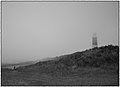 Sea mist
 -
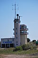 Humber Vessel traffic service
 -
 Spurn Point from the mainland
 -
 The old Low Light (1852) seen alongside the new (1895) lighthouse
 -
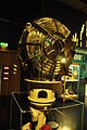 The 1957 optic in the National Maritime Museum
 -
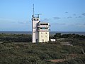 Humber Vessel traffic service
 -
 RNLI Platform


.jpg)


See also
editReferences
edit- ^ May, V. J. "Spurn Head" (PDF). defra.gov.uk. Geological Conservation Review. p. 2. Archived from the original (PDF) on 20 June 2017. Retrieved 24 June 2017.
- ^ Ratcliffe, Roger (29 October 2016). "Letting nature take its course: Why they're no longer defending Spurn Point". The Yorkshire Post. Retrieved 24 June 2017.
- ^ "Nostalgia on Tuesday: Point of interest". The Yorkshire Post. 20 November 2018. Retrieved 23 May 2020.
- ^ Ptolemy, Geography, 2.3.6.
- ^
 Smith, William, ed. (1854–1857). "Ocelum". Dictionary of Greek and Roman Geography. London: John Murray.
- ^ Bruce, J. (1838). Historie of the Arrivall of Edward IV. Camden Soc. 1. p. 4. OCLC 602067.
- ^ "History of Ravenser Odd". Archived from the original on 8 May 2009. Retrieved 15 August 2011.
- ^ Elliot, George H. (1875). European Light-House Systems. London: Lockwood & co. pp. 115–116. Retrieved 10 March 2019.
- ^ "Sails on Rails". Mike Munro. Retrieved 8 July 2009.
- ^ "Spurn National Nature Reserve". Yorkshire Wildlife Trust. Retrieved 23 January 2015.
- ^ "Spurn, Yorkshire's 'Land's End' five years on". BBC News. 26 December 2018. Retrieved 26 September 2019.
- ^ "Holderness, Countryfile – BBC One". BBC. Retrieved 23 July 2017.
- ^ Longhorn, Danny (29 September 2014). "Visitor centre plan for Spurn Point Nature Reserve". Hull Daily Mail. Retrieved 23 January 2015.
- ^ "The Spurn Visitor Centre" (PDF). Spurn Newsletter. No. 1. Yorkshire Wildlife Trust. September 2014. pp. 1–4. Retrieved 23 January 2015.
- ^ "East Yorkshire wildlife visitor centre plan rejected". BBC News. 18 July 2016. Retrieved 29 January 2017.
- ^ "Spurn gets go-ahead for wildlife visitor centre". BBC News. 26 January 2017. Retrieved 29 January 2017.
- ^ "Spurn visitor centre plans sparks opposition". Retrieved 23 July 2017.
- ^ "Spurn wildlife visitor centre opens despite objections". BBC News. 20 March 2018. Retrieved 6 October 2019.
- ^ "Humber lifeboat station leaves Spurn Point after 213 years of rescues". BBC News. 1 June 2023. Retrieved 30 September 2023.
- ^ Rowlett, Russ. "Lighthouses of Eastern England". The Lighthouse Directory. University of North Carolina at Chapel Hill. Retrieved 6 May 2016.
- ^ Historic England. "Spurn Lighthouse (Grade II) (1083476)". National Heritage List for England. Retrieved 21 May 2021.
- ^ a b c d "Lighthouse management : the report of the Royal Commissioners on Lights, Buoys, and Beacons, 1861, examined and refuted Vol. 2". 1861. p. 69.
- ^ "Lighthouse management : the report of the Royal Commissioners on Lights, Buoys, and Beacons, 1861, examined and refuted Vol. 1" (PDF). p. 30.
- ^ Admiralty Chart: Entrance to the River Humber 1875
- ^ de Boer, G. (1984) [1968]. A History of the Spurn lighthouses (PDF). East Yorkshire Local History Society. Retrieved 23 June 2014.
- ^ Mercantile Marine Fund: Minutes of Evidence Taken Before the Committee of Inquiry appointed by the President of the Board of Trade. London: HMSO. 1896. p. 281.
- ^ a b "Hyper-radial Lenses". United States Lighthouse Society. Retrieved 11 March 2019.
- ^ a b Jones, Robin (2014). Lighthouses of the North East Coast. Wellington, Somerset: Halsgrove. pp. 122–128. ISBN 978-0-85704-234-7.
- ^ "Spurn Point". Visit Hull and East Yorkshire. Retrieved 11 March 2019.
- ^ "Photo". Alamy. Retrieved 20 March 2019.
- ^ "Spurn Point lighthouse gets lottery renovation". BBC News. 18 September 2013. Retrieved 23 June 2014.
- ^ "Spurn Point lighthouse revamp work gets under way". BBC News. 10 April 2015. Retrieved 9 August 2016.
- ^ "Spurn Lighthouse opens to the public!". Yorkshire Wildlife Trust. 30 March 2016. Retrieved 20 March 2018.
Further reading
edit- Gazetteer – A–Z of Towns Villages and Hamlets. East Riding of Yorkshire Council. 2006. p. 10.