This article includes a list of general references, but it lacks sufficient corresponding inline citations. (January 2014) |
The southwestern tablelands comprise an ecoregion running from east-central to south-east Colorado, east-central and a small portion of eastern New Mexico, some eastern portions of the Oklahoma Panhandle, far south-central Kansas, and portions of northwest Texas. This ecoregion has a "cold semiarid" climate (Köppen BSk). Some years, a National Weather Service dust storm warning is issued in parts of Texas due to a dust storm originating from the lower part of the Southwestern Tablelands ecological region or from the southern end of the Western High Plains ecological region.[2]
| Southwestern Tablelands | |
|---|---|
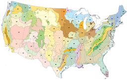
 Central Great Plains (area 26 on the map) | |
| Ecology | |
| Realm | Nearctic |
| Borders | List
|
| Bird species | [1] |
| Mammal species | [1] |
| Geography | |
| Country | United States |
| State | Colorado, Kansas, New Mexico, Oklahoma, Texas |
| Climate type | Cold semi-arid |
Included cities edit
- The Canadian River, north of Amarillo, Texas, is the central corridor of the Southwestern Tablelands.
- Snyder, Texas
- La Junta, Colorado
- Colorado Springs, Colorado
- The western edge is near Pueblo, Colorado, and Albuquerque, New Mexico
- The northern edge is south of Dodge City, Kansas
- The eastern edge is west of Woodward, Oklahoma
Environment edit
- Flora
In the northwestern region, the prevalent vegetation consists of grasses of the shortgrass prairie ecosystem and sagebrush.
- Fauna
See also edit
References edit
- ^ a b c d Hoekstra, J. M.; Molnar, J. L.; Jennings, M.; Revenga, C.; Spalding, M. D.; Boucher, T. M.; Robertson, J. C.; Heibel, T. J.; Ellison, K. (2010). Molnar, J. L. (ed.). The Atlas of Global Conservation: Changes, Challenges, and Opportunities to Make a Difference. University of California Press. ISBN 978-0-520-26256-0.
- ^ Dust storm#Dust storm visibility of 1.2F4 mile or less.2C or meters or less