Sêrtar County or Serthar County (Tibetan: གསེར་ཐར་རྫོང།; Chinese: 色达县) is a county in the northwest of Sichuan Province, China, bordering Qinghai province to the north. It is one of the 18 counties under the administration of the Garzê Tibetan Autonomous Prefecture, covering some 9,340 square kilometres. Sêrtar, which means "golden freedom" in Tibetan, lies in the southeast of the Tibetan Plateau and in the historical region of Kham. The vast majority of the population is Tibetan, followed by Han Chinese.
Sêrtar County
色达县 · གསེར་ཐར་རྫོང། Serthar, Sêrda, Seda | |
|---|---|
 | |
.png) Location of Sêrtar County (red) within Garzê Prefecture (yellow) and Sichuan | |
 Sêrtar Location of the seat in Sichuan  Sêrtar Sêrtar (China) | |
| Coordinates: 32°16′05″N 100°19′58″E / 32.2681°N 100.3327°E | |
| Country | China |
| Province | Sichuan |
| Autonomous prefecture | Garzê |
| County seat | Sêrkog (Seke) |
| Area | |
| • Total | 9,338.98 km2 (3,605.80 sq mi) |
| Elevation | 4,127 m (13,540 ft) |
| Population (2020)[1] | |
| • Total | 64,681 |
| • Density | 6.9/km2 (18/sq mi) |
| • Major nationalities | Tibetan Han Salar Hui |
| Time zone | UTC+8 (China Standard) |
| Postal code | 626600 |
| Area code | 0836 |
| Website | www |
| Sêrtar County | |||||||
|---|---|---|---|---|---|---|---|
| Chinese name | |||||||
| Simplified Chinese | 色达县 | ||||||
| Traditional Chinese | 色達縣 | ||||||
| |||||||
| Tibetan name | |||||||
| Tibetan | གསེར་ཐར་རྫོང། or གསེར་རྟ་རྫོང་། | ||||||
| |||||||
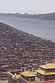
Sêrtar comprises 17 towns and 66 villages. It is home to the Larung Gar Buddhist Institute, the largest Tibetan Buddhist institute in the world. The institute, which was founded by lama Jigme Phuntsok in 1980 and started off with just a few monks, now houses tens of thousands of monks and pilgrims from around the world,[2] which constitute the vast majority of the Sêrtar population. Most monks spend six to 13 years completing their training. The institute, divided into two main segments and spread over just a few square kilometres, is located in a valley and around 15 kilometres from the town of Sêrtar. A permit is occasionally required for non-Chinese nationals to enter the institute.
Sêrtar is remotely located and requires more than half a day's driving if travelling from Chengdu via Maerkang. It is also possible to travel from Xining, the capital of Qinghai. Sêrtar is at an altitude of around 4,100 metres above sea level. Temperatures range from 30 degrees Celsius in the summer and -25 degrees Celsius in the winter.
Incidents
editSêrtar is one of the places in Sichuan that witnesses occasional acts of self-immolation, usually carried out by Tibetans. For instance, in February 2012, three herders set themselves on fire, purportedly in protest.[3] On 26 November 2012, a monk allegedly self-immolated in front of the golden horse statue in Larung Gar.[4] The supposedly political motivation behind these acts, however, has always been disputed by the Chinese government.[5]
As many of the houses in Larung Gar are made of wood, they present a constant fire hazard. On the evening of 10 January 2014, a fire broke out in Larung Gar, burning down more than a dozen structures and requiring 450 rescue workers to respond to the scene; however, there were no serious casualties.[6]
Administrative divisions
editSêrtar County is divided into 5 towns and 11 townships.
| Name | Simplified Chinese | Hanyu Pinyin | Tibetan | Wylie | Administrative division code | |
|---|---|---|---|---|---|---|
| Towns | ||||||
| Sêrkog Town (Seke) |
色柯镇 | Sèkē Zhèn | གསེར་ཁོག་གྲོང་རྡལ། | gser khog grong rdal | 513333100 | |
| Bomda Town (Wungda, Wengda) |
翁达镇 | Wēngdá Zhèn | སྦོ་མདའ་གྲོང་རྡལ། | sbo mda' grong rdal | 513333101 | |
| Nubsur Town (Larung, Luoruo) |
洛若镇 | Luòruò Zhèn | གནུབས་ཟུར་གྲོང་རྡལ། | gnubs zur grong rdal | 513333102 | |
| Nyidoi Town (Niduo) |
泥朵镇 | Níduǒ Zhèn | སྙི་སྟོད་གྲོང་རྡལ། | snyi stod grong rdal | 513333103 | |
| Gyaxoi Town (Jiaxue) |
甲学镇 | Jiǎxué Zhèn | རྒྱ་ཤོད་གྲོང་བརྡལ། | rgya shod grong brdal | 513333104 | |
| Townships | ||||||
| Kêgor Township (Keguo) |
克果乡 | Kèguǒ Xiāng | ཁེས་སྐོར་ཡུལ་ཚོ། | khes skor yul tsho | 513333201 | |
| Ragzham Township (Razham, Ranchong) |
然充乡 | Ránchōng Xiāng | རགས་བཀྲམ་ཡུལ་ཚོ། | rags bkram yul tsho | 513333202 | |
| Kainlêb Township (Karlêb, Kangle) |
康勒乡 | Kānglè Xiāng | མཁན་ལེབ་ཡུལ་ཚོ། | mkhan leb yul tsho | 513333203 | |
| Darcang Township (Dazhang) |
大章乡 | Dàzhāng Xiāng | བརྡར་ཚང་ཡུལ་ཚོ། | brdar tshang yul tsho | 513333204 | |
| Dagzê Township (Daze) |
大则乡 | Dàzé Xiāng | སྟག་རྩེ་ཡུལ་ཚོ། | stag rtse yul tsho | 513333205 | |
| Yarlung Township (Yalong) |
亚龙乡 | Yàlóng Xiāng | ཡར་ལུང་ཡུལ་ཚོ། | yar lung yul tsho | 513333206 | |
| Qogcang Township (Tazi) |
塔子乡 | Tǎzǐ Xiāng | མཆོག་ཚང་ཡུལ་ཚོ། | mchog tshang yul tsho | 513333207 | |
| Nyainlung Township (Nianlong) |
年龙乡 | Niánlóng Xiāng | སྙན་ལུང་ཡུལ་ཚོ། | snyan lung yul tsho | 513333208 | |
| Horxü Township (Huoxi) |
霍西乡 | Huòxī Xiāng | ཧོར་ཤུལ་ཡུལ་ཚོ། | hor shul yul tsho | 513333210 | |
| Xêchub Township (Xuri) |
旭日乡 | Xùrì Xiāng | ཤེལ་གྲུབ་ཡུལ་ཚོ། | shel grub yul tsho | 513333211 | |
| Yanggo Township (Yangge) |
杨各乡 | Yánggè Xiāng | ཡང་འོ་ཡུལ་ཚོ། | yang 'o yul tsho | 513333212 | |
Gallery
edit-
 A monk prostrating at a shrine
 -
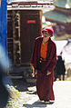 A nun walking the alleys
 -
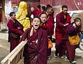 Children monks
 -
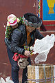 A worker and her child
 -
 With the mountain ranges in the background
 -
 Sêrtar at night
 -
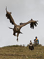 Vulture in flight during a sky burial


Panoramas
edit


Climate
edit| Climate data for Sêrtar, elevation 3,894 m (12,776 ft), (1991–2020 normals, extremes 1981–2010) | |||||||||||||
|---|---|---|---|---|---|---|---|---|---|---|---|---|---|
| Month | Jan | Feb | Mar | Apr | May | Jun | Jul | Aug | Sep | Oct | Nov | Dec | Year |
| Record high °C (°F) | 15.5 (59.9) |
14.1 (57.4) |
17.4 (63.3) |
20.5 (68.9) |
22.5 (72.5) |
23.6 (74.5) |
26.2 (79.2) |
23.7 (74.7) |
22.9 (73.2) |
20.9 (69.6) |
16.7 (62.1) |
13.1 (55.6) |
26.2 (79.2) |
| Mean daily maximum °C (°F) | 1.5 (34.7) |
3.5 (38.3) |
6.2 (43.2) |
9.7 (49.5) |
13.4 (56.1) |
15.9 (60.6) |
17.5 (63.5) |
17.3 (63.1) |
15.2 (59.4) |
10.2 (50.4) |
5.6 (42.1) |
2.5 (36.5) |
9.9 (49.8) |
| Daily mean °C (°F) | −9.9 (14.2) |
−7.0 (19.4) |
−3.0 (26.6) |
1.6 (34.9) |
5.6 (42.1) |
9.1 (48.4) |
10.6 (51.1) |
9.9 (49.8) |
7.3 (45.1) |
1.9 (35.4) |
−4.5 (23.9) |
−9.0 (15.8) |
1.1 (33.9) |
| Mean daily minimum °C (°F) | −18.8 (−1.8) |
−15.4 (4.3) |
−10.2 (13.6) |
−4.8 (23.4) |
−0.5 (31.1) |
3.9 (39.0) |
5.2 (41.4) |
4.3 (39.7) |
1.9 (35.4) |
−3.5 (25.7) |
−11.4 (11.5) |
−17.3 (0.9) |
−5.6 (22.0) |
| Record low °C (°F) | −32.2 (−26.0) |
−28.1 (−18.6) |
−23.4 (−10.1) |
−15.9 (3.4) |
−9.7 (14.5) |
−6.3 (20.7) |
−3.3 (26.1) |
−6.5 (20.3) |
−8.3 (17.1) |
−15.7 (3.7) |
−28.9 (−20.0) |
−32.0 (−25.6) |
−32.2 (−26.0) |
| Average precipitation mm (inches) | 4.1 (0.16) |
7.3 (0.29) |
18.2 (0.72) |
31.2 (1.23) |
69.8 (2.75) |
145.2 (5.72) |
139.3 (5.48) |
114.1 (4.49) |
107.1 (4.22) |
45.0 (1.77) |
7.5 (0.30) |
3.4 (0.13) |
692.2 (27.26) |
| Average precipitation days (≥ 0.1 mm) | 4.2 | 6.5 | 11.1 | 13.9 | 19.1 | 23.4 | 21.2 | 19.2 | 19.8 | 14.9 | 5.0 | 3.6 | 161.9 |
| Average snowy days | 6.7 | 9.9 | 15.1 | 17.8 | 12.6 | 1.9 | 0.2 | 0.3 | 2.8 | 15.1 | 8.1 | 5.3 | 95.8 |
| Average relative humidity (%) | 51 | 53 | 57 | 62 | 66 | 72 | 74 | 75 | 76 | 72 | 62 | 54 | 65 |
| Mean monthly sunshine hours | 208.2 | 179.9 | 194.7 | 203.8 | 202.7 | 177.5 | 197.8 | 197.3 | 179.5 | 180.0 | 210.0 | 221.0 | 2,352.4 |
| Percent possible sunshine | 65 | 57 | 52 | 52 | 47 | 42 | 46 | 48 | 49 | 52 | 67 | 71 | 54 |
| Source: China Meteorological Administration[7][8] | |||||||||||||
References
edit- ^ "甘孜州第七次全国人口普查公报(第二号)" (in Chinese). Government of Garzê Prefecture. 2021-06-04.
- ^ migration (20 June 2013). "Tibetan nun dies in self-immolation attempt: Reports".
- ^ LaFraniere, Sharon (6 February 2012). "Three Tibetan Herders Self-Immolate in Protest" – via NYTimes.com.
- ^ "Tibetan self-immolation locations". static.reuters.com.
- ^ "self immolation truth". www.chinaconsulatechicago.org.
- ^ "Fire hits massive Buddhist complex in Sichuan".
- ^ 中国气象数据网 – WeatherBk Data (in Simplified Chinese). China Meteorological Administration. Retrieved 13 April 2023.
- ^ 中国气象数据网 (in Simplified Chinese). China Meteorological Administration. Retrieved 13 April 2023.
External links
edit Media related to Sêrtar County at Wikimedia Commons