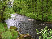
The River Dunsop is a river in the Forest of Bowland in Northern England. It flows into the River Hodder at Dunsop Bridge.[1]

It begins at the confluence of the Brennand River and Whitendale River, both of which rise high up in the surrounding moorland. It then flows through the steep-sided Dunsop Valley before meeting the Hodder.[1] An aqueduct carrying water to Blackburn runs alongside.
The Dunsop drains a catchment approximately 9 km by 5 km,[2] which comprises the sub-catchment areas of the Brennand and Whitendale, and is classed as a fifth order catchment.[2] The catchment is primarily Millstone Grit, but the tributaries run through older shale and limestone strata[2]
On 8 August 1967 Dunsop Valley entered the UK Weather Records with the Highest 90-min total rainfall at 117 mm. The peak flow of the flood was deduced primarily from wrack mark evidence and roughness coefficients.[3] As of July 2006 this record remains.
See also
editReferences
edit- ^ a b "Dunsop". Catchment Data Explorer. Environment Agency. Retrieved 25 November 2015.
- ^ a b c Mottershead, Derek; Suggitt, Steve (1992). "Spatial Variation in Stream Water Quality: A Scientific Approach". Teaching Geography. 17 (2): 66–69. JSTOR 23755912.
- ^ M. J. Lowing, M.J. (1975). Flood studies conference. pp. 23–26. doi:10.1680/fsc1975.00148. ISBN 978-0-7277-4736-5.
External links
editMedia related to River Dunsop at Wikimedia Commons
53°56′42″N 2°30′58″W / 53.945°N 2.516°W