Ranomafana is a rural municipality in Madagascar. It belongs to the district of Ifanadiana, which is a part of the region of Vatovavy. The population of the commune was 9,705 in the 2018.
Ranomafana | |
|---|---|
 Ranomafana | |
 Ranomafana Location in Madagascar | |
| Coordinates: 21°15′S 47°27′E / 21.250°S 47.450°E | |
| Country | |
| Region | Vatovavy |
| District | Ifanadiana |
| Area | |
| • Total | 245 km2 (95 sq mi) |
| Elevation | 876 m (2,874 ft) |
| Population (2018) | |
| • Total | 9,705 |
| Time zone | UTC3 (EAT) |
| Postal code | 312 |
Primary and junior level secondary education are available in the town. 60% of the population of the commune are farmers; the most important crops are bananas and rice, while other important agricultural products are pineapple and cassava. Services provide employment for 40% of the population.[3]
Roads
editThe commune is situated at 62 km from Fianarantsoa and 138 km from Mananjary along the National Road 25.
Rivers
editThe municipality is crossed by the Namorona River. There are also the Andriamamovoka Falls, a waterfall on the Namorona near the fokontany of Vohiparara.[4]
Sights and Infrastructure
editThere is an outdoor swimming pool and bath filled by hot water springs. A well-kept park can be visited close to the outdoor pool. A number of hotels are found throughout the village, accommodating tourist that come to visit the nearby Ranomafana National Park. Ranomafana has a hospital. The Town Hall (Lapan'ny tanana) is on the main road. The Post Office and the Market are at Place de l'Indépendance where a memorial dedicated to the victims of the Malagasy Uprising of 1947 was erected. The Catholic Church was consecrated by bishop François Xavier Tabao Manjarimanana in 1988.[5] The Protestant Church is on a small hill offering a beautiful view of the town centre.
-
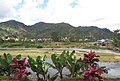 General view of Ranomafana
 -
 Town Hall
 -
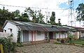
 Hospital
 -
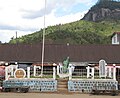 Monument
 -
 Public pool
 -
 Public parc near the hot springs
 -
 Post office
 -
 Catholic church
 -
 Catholic church
 -
 Protestant Church
 -
 Protestant Church
 -
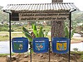 Campaign to keep the town clean


See also
edit- Ranomafana National Park at 6.5 km from Ranomafana.
References
edit- ^ RAMAMONJISOA, 2014. ARBORETUM COMMUNAL ET INTEGRATION AU DEVELOPPEMENT DURABLE - COMMUNE RURALE DE RANOMAFANA
- ^ Estimated based on DEM data from Shuttle Radar Topography Mission
- ^ "ILO census data". Cornell University. 2002. Retrieved 2008-05-03.
- ^ L'Express.mg: Ranomafana: Un homme glisse dans une cascade
- ^ Commemorative stone at the church, to be seen at Wikipedia Commons
21°15′S 47°27′E / 21.250°S 47.450°E
This Vatovavy location article is a stub. You can help Wikipedia by expanding it. |