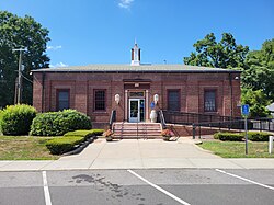
Portland is a census-designated place (CDP) comprising the primary village and adjacent residential land in the town of Portland, Middlesex County, Connecticut, United States. It is in the southwest part of the town, bordered to the west and south by the Connecticut River, which forms the border with Cromwell to the west and Middletown to the south. The Portland CDP extends north along Main Street (Connecticut Route 17A) to its junction with Gospel Lane (Connecticut Route 17) at Fogelmarks Corners, and the eastern extent of the CDP is at Rose Hill Road and Collins Hill Road. The CDP includes the neighborhood of Gildersleeve in the north.
Portland, Connecticut | |
|---|---|
 Post Office | |
| Coordinates: 41°34′44″N 72°37′54″W / 41.57889°N 72.63167°W | |
| Country | |
| State | Connecticut |
| County | Middlesex |
| Town | Portland |
| Area | |
• Total | 17.16 km2 (6.63 sq mi) |
| • Land | 15.53 km2 (6.00 sq mi) |
| • Water | 1.63 km2 (0.63 sq mi) |
| Elevation | 50 m (170 ft) |
| Population | |
• Total | 5,813 |
| • Density | 374.4/km2 (970/sq mi) |
| Time zone | UTC-5 (Eastern (EST)) |
| • Summer (DST) | UTC-4 (EDT) |
| ZIP Code | 06480 |
| Area code(s) | 860/959 |
| FIPS code | 09-61870 |
| GNIS feature ID | 2377853[2] |
As of the 2020 census, the CDP had a population of 5,813,[3] out of 9,384 in the entire town of Portland.
References
edit- ^ "2022 U.S. Gazetteer Files: Connecticut". United States Census Bureau. Retrieved December 12, 2022.
- ^ a b "Portland Census Designated Place". Geographic Names Information System. United States Geological Survey, United States Department of the Interior.
- ^ a b "P1. Race – Portland CDP, Connecticut: 2020 DEC Redistricting Data (PL 94-171)". U.S. Census Bureau. Retrieved December 12, 2022.

