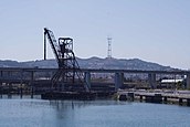
Islais Creek or Islais Creek Channel (previously known as Du Vrees Creek, Islais Channel and Islais Swamp) is a small creek in San Francisco, California. The current name of the creek is said to be derived from a Salinan Native American word "slay" or "islay," the name for the Prunus ilicifolia wild cherries. Once the largest body of water in the city, almost the entire creek today is covered by landfill and converted to an underground culvert and a storm drain, with remnants of the creek flowing at both Glen Canyon Park and near Third Street.
The original Islais Creek stretched from the San Francisco Bay 3.5 miles (5.6 km) west into the Glen Canyon Park and O’Shaughnessy Hollow. The creek, once the largest body of water within San Francisco covering an area of 5,000 acres (7.813 sq mi; 20.234 km2), had two branches. One branch originated near the southern slope of Twin Peaks, formerly known as San Miguel Hills, slightly north of today's Portola Drive. It then coursed through Glen Canyon and through what is now Bosworth Street until it reached the bottom of the Mission Street viaduct at I-280. The other branch began at the Cayuga Avenue and Regent Street intersection. The creek flowed from the intersection down to the Mission Street viaduct where the two branches joined. (Full article...)
