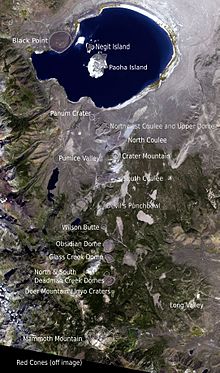
The Mono–Inyo Craters are a volcanic chain of craters, domes and lava flows in Mono County, Eastern California. The chain stretches 25 miles (40 km) from the northwest shore of Mono Lake to the south of Mammoth Mountain. The Mono Lake Volcanic Field forms the northernmost part of the chain and consists of two volcanic islands in the lake and one cinder cone volcano on its northwest shore. Most of the Mono Craters, which make up the bulk of the northern part of the Mono–Inyo chain, are phreatic (steam explosion) volcanoes that have since been either plugged or over-topped by rhyolite domes and lava flows. The Inyo volcanic chain form much of the southern part of the chain and consist of phreatic explosion pits, and rhyolitic lava flows and domes. The southernmost part of the chain consists of fumaroles and explosion pits on Mammoth Mountain and a set of cinder cones south of the mountain; the latter are called the Red Cones.
The region has been used by humans for centuries. Obsidian was collected by Mono Paiutes for making sharp tools and arrow points. Glassy rock continues to be removed in modern times for use as commercial scour and yard decoration. Mono Mills processed timber felled on or near the volcanoes for the nearby boomtown Bodie in the late 19th to early 20th centuries. Water diversions into the Los Angeles Aqueduct system from their natural outlets in Mono Lake started in 1941 after a water tunnel was cut under the Mono Craters. Mono Lake Volcanic Field and a large part of the Mono Craters gained some protection under Mono Basin National Forest Scenic Area in 1984. Resource use along all of the chain is managed by the United States Forest Service as part of Inyo National Forest. Various activities are possible along the chain, including hiking, bird watching, canoeing, skiing, and mountain biking. (Full article...)
