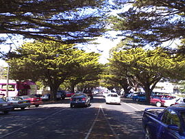
Phillip Island Road is a tourist highway in Victoria, Australia and branches off the Bass Highway at the township of Anderson. Previously assigned State Route 186, it was later designated B420. It was named due to the Phillip Island Bridge which opened in San Remo on the 21 November 1969.[1]
Phillip Island Road | |
|---|---|
 | |
| Phillip Island Road, Cowes | |
| General information | |
| Type | Road |
| Length | 25 km (16 mi) |
| Route number(s) | |
| Former route number | |
| Major junctions | |
| West end | The Esplanade Cowes, Victoria |
| |
| East end | Anderson, Victoria |
| Location(s) | |
| Major suburbs | Wimbledon Heights, Cape Woolamai, San Remo |
Major intersections edit
| LGA | Location | km | mi | Destinations | Notes |
|---|---|---|---|---|---|
| The Esplanade – Cowes | |||||
| Cowes – Rhyll Road (east) – Cowes, Rhyll Ventnor Road (C473 west) – Ventnor, Summerlands | |||||
| Back Beach Road (C478) – Summerlands | |||||
| Old Phillip Island Road (C439) – Wonthaggi via Bass Highway (B460) | |||||
| Bass Highway (M420) – Melbourne | |||||
See also edit
References edit
- ^ "San Remo Bridge: The Gateway to Phillip Island". Phillip Island Tours. Retrieved 25 October 2020.