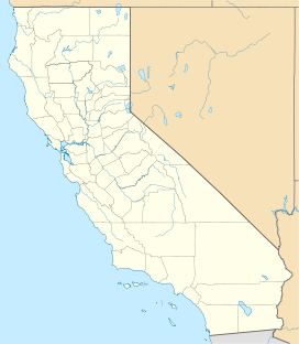
Packsaddle Grove is a medium-sized sequoia grove on Giant Sequoia National Monument located in the South Creek of the Kern River watershed. It is a fairly wet grove as it straddles Packsaddle Creek and its tributaries.
| Packsaddle Grove | |
|---|---|
| Geography | |
| Location | Tulare County, California, United States |
| Coordinates | 35°55′26″N 118°35′34″W / 35.923889°N 118.592778°W |
| Elevation | 6,760 ft (2,060 m) |
| Ecology | |
| Dominant tree species | Sequoiadendron giganteum |
This compact grove offers a rare look at a truly old growth forest where California condors have lived, and may once again do. The main access to this grove is via dirt roads and cross-country hiking. The terrain is steep, so it's a difficult hike. You can only visit this grove in the summer when the roads are open. The main option for seeing the grove itself is to hike cross-country through it.
This grove was heavily impacted by the Windy Fire in 2021, with over a third of the grove burning at high severity.[1]
Noteworthy trees edit
- Packsaddle Giant, which was killed in the Windy Fire. It had a volume of approx. 32,156 cubic feet (910.6 m3) and the fourth-largest ground perimeter of any sequoia at 107 feet (33 m), making it the largest giant sequoia south of Stagg.[2]
- Candelabra Tree, with a volume of 26,341 cubic feet (745.9 m3), It has many large limbs that lead to a great crown of foliage.
- Ghost Tree (sometimes referred to as General Lee Tree, of which however exist several in different groves), a once much larger tree with a heavily broken top, but growing a new top shoot (leader). This tree has a volume of 25,047 cubic feet (709.3 m3). It was heavily damaged in the Windy Fire.[2]
See also edit
References edit
- ^ Alonzo, Denise (November 3, 2021). "Sequoia grove damage assessments continue". U.S. Forest Service.
- ^ a b "Windy Fire Firsthand Report: Starvation Creek, Deer Creek, Packsaddle, Long Meadow". I Love Trees. Retrieved 2021-12-11.
