Pétervására (Hungarian: Pétervásárai járás) is a district created in 2013 in the north-western part of Heves County. Pétervására is also the name of the town where the district seat is found. The district is located in the Northern Hungary Statistical Region.
Pétervására District
Pétervásárai járás | |
|---|---|
 Coat of arms | |
 Pétervására District within Hungary and Heves County. | |
| Country | |
| County | Heves |
| District seat | Pétervására |
| Area | |
| • Total | 475.07 km2 (183.43 sq mi) |
| • Rank | 5th in Heves |
| Population (2011 census) | |
| • Total | 21,433 |
| • Rank | 6th in Heves |
| • Density | 45/km2 (120/sq mi) |
Geography
editPétervására District borders with Salgótarján District (Nógrád County) and Ózd District (Borsod-Abaúj-Zemplén County) to the north, Bélapátfalva District and Eger District to the east, Gyöngyös District to the south, Bátonyterenye District (Nógrád County) to the west. The number of the inhabited places in Pétervására District is 20.
Municipalities
editThe district has 1 town, 2 large villages and 17 villages. (ordered by population, as of 1 January 2012)[1]
- Bodony (714)
- Bükkszék (681)
- Bükkszenterzsébet (1,040)
- Erdőkövesd (640)
- Fedémes (309)
- Istenmezeje (1,525)
- Ivád (366)
- Kisfüzes (127)
- Mátraballa (714)
- Mátraderecske (1,839)
- Parád (1,964)
- Parádsasvár (409)
- Pétervására (2,464) – district seat
- Recsk (2,656)
- Sirok (1,846)
- Szajla (612)
- Szentdomonkos (447)
- Tarnalelesz (1,663)
- Terpes (194)
- Váraszó (492)
The bolded municipality is city, italics municipalities are large villages.
Demographics
editReligion in Pétervására District (2011 census)
In 2011, it had a population of 21,433 and the population density was 50/km².
| Year | County population[2] | Change |
|---|---|---|
| 2011 | 21,433 | n/a |
Ethnicity
editBesides the Hungarian majority, the main minority is the Roma (approx. 2,500).
Total population (2011 census): 21,433
Ethnic groups (2011 census):[3] Identified themselves: 21,622 persons:
- Hungarians: 18,794 (86.92%)
- Gypsies: 2,559 (11.84%)
- Others and indefinable: 269 (1.24%)
Approx. 200 persons in Pétervására District did declare more than one ethnic group at the 2011 census.
Religion
editReligious adherence in the county according to 2011 census:[4]
- Catholic – 13,941 (Roman Catholic – 13,870; Greek Catholic – 68);
- Reformed – 467;
- Evangelical – 60;
- other religions – 519;
- Non-religious – 1,929;
- Atheism – 137;
- Undeclared – 4,380.
Gallery
edit-
 District office, Pétervására
 -

-
 Károlyi Mansion in Parádsasvár
 -
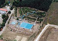 Spa in Bükkszék


_(5819._sz%C3%A1m%C3%BA_m%C5%B1eml%C3%A9k).jpg)

See also
editReferences
edit- ^ A KSH 2012. évi helységnévkönyve
- ^ népesség.com, "Pétervásárai járás népessége"
- ^ 4.1.6.1 A népesség nemzetiség szerint, 2011, (in Hungarian) [1]
- ^ 4.1.7.1 A népesség vallás, felekezet szerint, 2011, (in Hungarian) [2]
External links
edit48°00′00″N 20°05′00″E / 48.0000°N 20.0833°E
This Heves county location article is a stub. You can help Wikipedia by expanding it. |