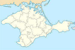
Okhotnykove (Ukrainian: Охотникове; Russian: Охотниково, romanized: Okhotnikovo), known officially until 1948 by its Crimean Tatar name of Cağa Quşçu (Ukrainian: Джага-Кущи, romanized: Dzhaha-Kushchy; Russian: Джага́-Кущу́, romanized: Dzhaga-Kushchu) is a village in Crimea, a peninsula internationally recognised as part of Ukraine but occupied by Russia since 2014. It is currently administered as part of Saky Raion.
Okhotnykove
| |
|---|---|
 Cağa Quşçu Camisi mosque in Okhotnikovo | |
| Coordinates: 45°14′21″N 33°35′39″E / 45.23917°N 33.59417°E | |
| Country | (occupied by Russia) |
| Republic | |
| Raion | |
| First mentioned | 1806 |
| Population (2014) | |
| • Total | 1,550 |
History
editOkhotnykove was first mentioned in a document dating to 19 April 1806, where its population was listed, in seventeen households, as including 105 Crimean Tatars, ten Crimean Roma, and four slaves.[1] Between 1860 and 1864, the village was completely depopulated after its inhabitants fled amidst the Crimean War, and repopulated by Volga Tatars.[2]
In 1926, the village had a population of 95. Of this population, 59 were Ukrainians, 24 were Tatars, and 13 were Estonians.[3] With the deportation of the Crimean Tatars, the village was renamed to Okhotnykove by an act of the Presidium of the Supreme Soviet on 18 May 1948.[4]
In 2011, the Okhotnykovo Solar Park was constructed in the village by Activ Solar.[5]
Demographics
editAccording to the 2001 Ukrainian census, 69.7 percent of people in Okhotnykove spoke Russian, with 16.8 percent speaking Ukrainian and another 12.2 percent speaking Crimean Tatar.[6] The total population of Okhotnykove was 1,550 according to the 2014 Crimean census,[7] a decline from its 2001 population of 1,696.[8]
References
edit- ^ Lashkov, Fyodor (1897). Сборник документов по истории Крымско-татарского змлевладения (Окончание) [Collection of Documents on the History of Crimean Tatar Land Ownership] (in Russian). Simferopol: Tavrich. Gub. Tip. p. 151.
- ^ Khanatskago, K. V. (1867). Памятная книжка Таврической губерніи [Memorial Book of Taurida Governorate] (in Russian). Simferopol: Printing House of Taurida Governorate. p. 427.
- ^ Список населенных пунктов Крымской АССР [List of settlements in the Crimean ASSR] on Wikimedia Commons. Accessed 8 August 2023
- ^ Указ Президиума ВС РСФСР от 18.05.1948 о переименовании населённых пунктов Крымской области [Act by the Presidium of the SS RSFSR from 18.5.1948 on renaming settlements in the Crimean Oblast] on Wikisource. Accessed 8 August 2023
- ^ "Mission accomplished for Activ Solar: final phase of Ukraine solar plant completed". pv-tech.org. 30 September 2011.
- ^ "Розподіл населення за рідною мовою, Автономна Республіка Крим" [Population distribution by native language, Autonomous Republic of Crimea]. All-Ukrainian Population Census (in Ukrainian). Archived from the original on 6 March 2016. Retrieved 8 August 2023.
- ^ "Таблицы с итогами Федерального статистического наблюдения "Перепись населения в Крымском федеральном округе"" [Tables with the results of the Federal Statistical Observation "Population Census in the Crimean Federal District"]. Federal State Statistics Service of Russia (in Russian). Archived from the original on 24 September 2015. Retrieved 8 August 2023.
- ^ "Автономна Республіка Крим" [Autonomous Republic of Crimea]. Pop-stat.mashke.org (in Ukrainian). Archived from the original on 4 October 2013. Retrieved 8 August 2023.

