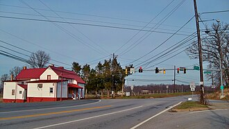
Norwood is an unincorporated community in Montgomery County, Maryland, United States,[1] located at the intersection of Layhill Road (MD 182), Norwood Road (also MD 182), and Ednor Road, two miles from the Intercounty Connector (ICC).

Norwood was named Holland's Corner at one time from a store opened circa 1860 by James Holland.[2] In 1889, Holland became the first postmaster of the town, which was renamed Norwood around the same time.[2][3] The Red Door Country Store,[2] at the corner of Norwood Road and Ednor Road, was a general store owned by Marie E. Smith[4] that had a scale on which farmers weighed their grain.[5] The store also served as a post office after the closure of the post office in nearby Ednor, Maryland.[6]

Norwood as a toponym is largely unused and this lack of use gained local prominence due to the use of "Norwood" as one of two "key destinations" listed on signs for the Layhill Road interchange on the ICC (Exit 10).[7]
References
edit- ^ U.S. Geological Survey Geographic Names Information System: Norwood, Maryland
- ^ a b c Sandy Spring Museum: Ednor/Norwood. Retrieved 6 January 2012.[dead link]
- ^ "Forgotten village of norwood makes comeback with ICC sign" at JustUpThePike.com. 5 December 2011. Retrieved 6 January 2012.
- ^ "Marie E. Smith". The Washington Post. July 3, 1986. p. D6. ProQuest 138986194.
- ^ Kyriakos, Marianne (June 9, 1989). "Chaws, Saws And Geegaws". The Washington Post. p. N62. ProQuest 140010517.
- ^ "Ednor Fights Plan to Close Post Office". The Washington Post. October 17, 1959. p. D4. ProQuest 140956849.
- ^ Katherine Shaver. "Take the ICC and exit at Norwood — where?" Washington Post. 6 January 2012. Retrieved 6 January 2012.
External links
edit39°07′31″N 77°01′39″W / 39.12528°N 77.02750°W