Neumayer Glacier is a glacier, 8 nautical miles (15 km) long and 2 nautical miles (3.7 km) wide, which flows east along the north flank of the Allardyce Range to the west side of the head of Cumberland West Bay, South Georgia. Charted by the Swedish Antarctic Expedition under Otto Nordenskiöld, 1901–04, and named for Georg von Neumayer.
| Neumayer Glacier | |
|---|---|
 Location of Neumayer Glacier in South Georgia | |
| Location | South Georgia |
| Coordinates | 54°15′S 36°41′W / 54.250°S 36.683°W |
| Length | 8 nmi (15 km; 9 mi) |
| Width | 2 nmi (4 km; 2 mi) |
| Thickness | unknown |
| Terminus | Cumberland West Bay |
| Status | unknown |
Between 2005 and 2009, the glacier retreated 1-kilometer (0.62 mi).[1]
See also
editGallery
edit-
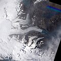 Neumayer Glacier in January 2005
 -
 Neumayer Glacier in January 2009
 -
 Neumayer Glacier, Cumberland West Bay, South Georgia, circa 1882
 -
 Neumayer Glacier, Cumberland West Bay, South Georgia, circa 1882


References
edit- ^ "Neumayer Glacier, South Georgia Island". Image of the Day. NASA. Retrieved 9 May 2011.
![]() This article incorporates public domain material from "Neumayer Glacier". Geographic Names Information System. United States Geological Survey.
This article incorporates public domain material from "Neumayer Glacier". Geographic Names Information System. United States Geological Survey.
54°15′S 36°41′W / 54.250°S 36.683°W
This article about a glacier in South Georgia and the South Sandwich Islands is a stub. You can help Wikipedia by expanding it. |