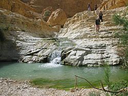
Nahal Arugot (Hebrew: נחל ערוגות, Arabic: وادي العريجة) is a stream that drains many streams in the center of the Judean desert. The stream is a popular hiking destination located in the Ein Gedi Nature Reserve in Israel. The area offers various hiking trails, suitable for different levels of hikers, and features landscapes, water streams, waterfalls, and historical sites. There are two primary hiking routes in Nahal Arugot: a shorter, family-friendly trail and a longer, more challenging circuit.[1][2]
| Nahal Arugot | |
|---|---|
 | |
| Location | |
| State | Israel |
| Physical characteristics | |
| Length | 31 km |

Geography
editNahal Arugot is a large stream with a drainage basin of over 230 square kilometers. The stream begins in the area of Efrat, Migdal Oz, and Beit Fajjar, from where it flows eastward for about 8 kilometers until it enters the desert plateau. At this point, the stream turns south-southeast and continues in this direction for about 30 kilometers, collecting numerous tributaries until it reaches the eastern edge of the plateau. Here, the stream turns directly eastward towards the Dead Sea and the Syrian-African Rift Valley. In this section, it becomes increasingly canyon-like, and in its final kilometers before reaching the Dead Sea, it descends into a massive canyon over 500 meters deep, where spring waters flow year-round.
The final section of the stream begins in a narrow, deep gorge interrupted by a high waterfall (Arugot Waterfall). Below Arugot Waterfall, Ein Arugot springs emerge, and from there on, the stream becomes a perennial stream with rich riparian vegetation, including willow trees, Euphrates poplars, common reed, giant reed, Salvadora persica, and jujube trees. In the perennial section of the stream, herds of ibex and large groups of rock hyraxes can be found.
A hiking trail passes through the final canyon, starting from the reserve parking lot and leading to the "Hidden Waterfall" and the "Upper Pools" in the stream. Additionally, two challenging trails connect to the stream from the mountains above: Ma'ale Bnei HaMoshavim from the north and Ma'ale HaIssiyim from the south.
Name
editIn Arabic, Nahal Arugot has several names according to its sections:
The upper part descending from the Hebron Hills to the desert plateau is called Wadi Jihar (وادي جحر), meaning "the stream hidden in its hole".[3] This section is a deep canyon with caves containing remains of prehistoric human activity. The middle part, crossing the Judean Desert plateau, is called Wadi Al-Ghar (وادي الغر), meaning "the stream of the Abraham shrub,"[4] named after the numerous Abraham shrubs growing there. The deepest and final section of the stream is called Wadi Al-‘Arija (وادي العريجة), meaning "the stream that deviated from its path." This name is a preservation of an ancient name and has been officially designated by the Government Naming Committee as Nahal Arugot.
Hiking trails in the stream
editShort Hike
editDistance: 4 kilometres (2.5 mi) (out and back)
Climb: 150 metres (490 ft)
Level: Easy
The short hike begins at the Nahal Arugot ticket office, where hikers walk upstream along the Red Trail. After approximately 1.5 kilometers, there is a junction with a Blue Trail. Turning left onto the Blue Trail, hikers will traverse through the gorge near the stream, sometimes wading in shallow water. This section leads to the “Hidden Waterfall,” a 10-meter waterfall that drops into a deep pool, perfect for swimming and relaxing. Hikers can continue another kilometer upstream to explore the “Upper Pools.” The return journey follows the same route or the higher, dry Red Trail.[5]
Long Hike
editDistance: 8 kilometres (5.0 mi) (circular)
Climb: 500 metres (1,600 ft)
Level: Moderate
The longer hike also starts at the Nahal Arugot ticket office but heads down the paved road to Tel Goren, the location of ancient Ein Gedi, where the Black-marked trail begins. Hikers ascend the hill to reach the Ein Gedi Spring, a picnic spot with shade and a fresh water pool. Continuing past the spring, the trail passes near the remains of a Chalcolithic temple, leading to the “Ein Gedi Ascent,” an ancient path negotiating a steep cliff with views of the Dead Sea.[5]
Following the Black Trail on the desert plateau, hikers make a detour to the Ein Gedi lookout and then proceed to the top of the Nahal Arugot Canyon. Descending the steep trail, they reach the bottom of the canyon and turn right onto a Red-marked path leading to the Hidden Waterfall. After a dip in the pool, the return journey follows the Red-marked trail back to the park entrance.[5]
Points of interest
edit- Hidden Waterfall: A 10-meter waterfall dropping into a deep pool.
- Upper Pools: Located further upstream from the Hidden Waterfall.
- Ein Gedi Spring.
- Chalcolithic Temple: Remains of an ancient temple dating back to 3500 BCE.
- Ein Gedi Ascent: An ancient path with historical and biblical significance, providing stunning views of the Dead Sea.
- Desert Plateau and Lookout Points: Panoramic views of the Dead Sea and the surrounding landscape.
References
edit- ^ "Nahal Arugot (Stream) Long and Short Hikes - With Maps!". Retrieved 2024-07-07.
- ^ "Nahal Arugot". Israel Extreme Private Tours. Retrieved 2024-07-07.
- ^ "Hike with the Nomads: Wadi Jihar Hike and Bedouin Life at the Edge of the Desert • Finjan". Finjan. Retrieved 2024-07-07.
- ^ "Rashayida to Wadi al-Ghar". Palestine Trails. Retrieved 2024-07-07.
- ^ a b c Susannah (2018-12-26). "Nahal Arugot and the Fairy Pools". Hiking the Holyland. Retrieved 2024-07-07.