När Lighthouse is a Swedish lighthouse located outside the village När on the southeast side of the island Gotland. It was constructed in 1872, the sketchings were made by architect John Höjer. It is located in a nature reserve and birding area. It is a listed building in Sweden.
 När Lighthouse | |
 | |
| Location | Närsholmen Gotland Sweden |
|---|---|
| Coordinates | 57°13′06″N 18°40′52″E / 57.218312°N 18.681091°E |
| Tower | |
| Constructed | 1872 |
| Construction | cast iron tower |
| Automated | 1961 |
| Height | 16.3 metres (53 ft) |
| Shape | tapered cylindricall tower with balcony and lantern |
| Markings | red tower with three narrow white bands, greenish lantern dome |
| Power source | kerosene, acetylene, electricity |
| Operator | Swedish Maritime Administration (Sjöfartsverket)[1][2][3] |
| Heritage | governmental listed building complex, governmental listed building |
| Light | |
| Focal height | 20.8 metres (68 ft) |
| Lens | 3rd order rotating Fresnel lens (original), 4th order dioptric lens (1961) |
| Range | white: 16.5 nautical miles (30.6 km; 19.0 mi) red: 13.5 nautical miles (25.0 km; 15.5 mi) |
| Characteristic | Oc WR 8s. |
| Sweden no. | SV-4190 |
The light originally carried a kerosene lamp and it was updated with electric power in 1961. It was also automated that same year, and the rotating lens was replaced by a modern one. It is owned by the Swedish Maritime Administration.[4][5]
Gallery
edit-
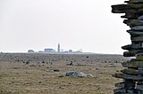 The light station as seen from a distance.
 -
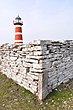 Stone wall near the lighthouse.
 -
 Sparse vegetation surrounds this light station.


See also
editReferences
edit- ^ Rowlett, Russ. "Lighthouses of Sweden: Gotland". The Lighthouse Directory. University of North Carolina at Chapel Hill. Retrieved 2016-04-05.
- ^ Lighthouse När (Gotland) www.leuchtturmseiten.de
- ^ Leuchtturm När www.schwedische-leuchtfeuer.de
- ^ Rowlett, Russ. "Lighthouses of Sweden: Gotland". The Lighthouse Directory. University of North Carolina at Chapel Hill. Retrieved 27 August 2012.
- ^ "Swedish Lighthouse Society". www.fyr.se. The Swedish Lighthouse Society. Archived from the original on 14 March 2012. Retrieved 25 June 2015.
External links
editWikimedia Commons has media related to När fyr.
- Sjofartsverket Archived 2016-04-08 at the Wayback Machine (in English)
- The Swedish Lighthouse Society
This European lighthouse-related article is a stub. You can help Wikipedia by expanding it. |