Monte Albergian is a 3,041 m a.s.l. mountain of the Cottian Alps, located in Italy. A battalion of 3rd Alpini Regiment, which during World War I earned a Silver Medal of Military Valor, was named after Monte Albergian.[4]
| Monte Albergian | |
|---|---|
 The mountain as seen from Colle dell'Albergian | |
| Highest point | |
| Elevation | 3,041 m (9,977 ft)[1] |
| Prominence | 428 m (1,404 ft)[2][3] |
| Isolation | 9.29 km (5.77 mi) |
| Listing | Alpine mountains above 3000 m |
| Coordinates | 44°58′58.8″N 06°58′58.8″E / 44.983000°N 6.983000°E |
| Geography | |
 Monte Albergian Alps | |
| Location | Piedmont, Italy |
| Parent range | Cottian Alps |
| Climbing | |
| Easiest route | foothpath |
Etymology edit
The name Albergian could come from the ancient Celtic population of the Egyans (in Italian Egidini) and could mean High Egyans' mountain (Alberg-Egyan) in their language.[5] Another theory link the name of the mountain the Janus, a Roman solar deity.[6]
Geography edit
The mountain is located on a brief ridge heading North which originates from the water divide between Val Chisone and Valle Germanasca. Going South an unnamed saddle at 2,906 m divides Monte Albergian from Monte Gran Miuls (2,974 m a.s.l.), the latter standing on the Germanasca/Chisone water divide.[1]
Administratively the eastern face of the Albergian belongs to the Fenestrelle municipality (comune) and the western one to Pragelato municipality,[1] both in the Metropolitan City of Turin. In clear days its summit, marked by a cross, offers a great view of Western Alps.[7]
SOIUSA classification edit
According to SOIUSA (International Standardized Mountain Subdivision of the Alps) the mountain can be classified in the following way:[8]
- main part = Western Alps
- major sector = North Western Alps
- section = Cottian Alps
- subsection = Alpi del Monginevro
- supergroup = Catena Bucie-Grand Queyron-Orsiera
- group = Gruppo Queyron-Albergian-Sestrière
- subgroup = Sottogruppo Ghinivert-Albergian
- code = I/A-4.II-A.2.b
Access to the summit edit
The usual route to Monte Albergian is the waymarked footpath starting from Soucheres Hautes (1,518 m), a frazione (village) of Pragelato municipality. While long (more than 1,500 metres of vertical drop) the route does not require alpine skills.[9] In the Italian scale of hiking difficulty is rated E (Escursionisti, namely suitable for normal hikers).[10] On the WSW ridge of Albergian was described a climbing route of F+ grade.[9]
References edit
- ^ a b c "Geoportale Nazionale - carta IGM 1:25.000". Istituto Geografico Militare. Retrieved 2017-02-23.
- ^ Key col: Colle del Pis, 2613 m
- ^ "Monte Albergian, Italy". Retrieved 2017-02-23.
- ^ "Storia del Terzo Alpini". Retrieved 2017-02-23.
- ^ "Preistoria valdese". Bollettino della Società di studi valdesi (70). Società di Studi Valdesi: 14. 1938. Retrieved 2017-02-24.
- ^ Marino, Ugo (1966). Storia di Pinerolo e dei Principi d'Acaja. Tipografia Vescovile. p. 15.
- ^ "Monte Albergian m 3041". Retrieved 2017-02-23.
- ^ Marazzi, Sergio (2005). Atlante Orografico delle Alpi. SOIUSA (in Italian). Priuli & Verlucca. ISBN 978-88-8068-273-8.
- ^ a b Ferreri, Eugenio (1982). Alpi Cozie cenrali. C.A.I./T.C.I. pp. 237–239.
- ^ users Andrea72 and renato63 (2010-07-21). "Albergian (Monte) da Pragelato". Retrieved 2017-02-23.
{{cite web}}: CS1 maint: numeric names: authors list (link)
Photo gallery edit
-
 Albergian from Colle delle Finestre
 -
 The mountain seen from Gran Puy (a frazione of Pragelato)
 -
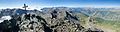 Summit cross and panorama


Maps edit
- Istituto Geografico Militare (IGM) official maps of Italy, 1:25.000 and 1:100.000 scale, on-line version
- Istituto Geografico Centrale (I.G.C.) - Carta dei sentieri e dei rifugi scala 1:50.000 n. 1 Valli di Susa Chisone e Germanasca