Module talk:Iraqi insurgency detailed map/Archive 5
| This is an archive of past discussions. Do not edit the contents of this page. If you wish to start a new discussion or revive an old one, please do so on the current talk page. |
| Archive 1 | ← | Archive 3 | Archive 4 | Archive 5 |
Battle of Fallujah
Information to the editors here: I'm making up a SVG map for the battle of Fallujah. Could someone help me later including it to the map?--Ermanarich (talk) 17:31, 23 May 2016 (UTC) Ok, the map won't come. It's too small for the map. Furthermore I have problems to get exact positions inside the city...--Ermanarich (talk) 21:09, 23 May 2016 (UTC)
Sources for my edit
Sources for this edit [1] are [2] and [3]. --Ahmedo Semsurî (talk) 21:29, 23 May 2016 (UTC)
Southeastern Kirkuk Province
Too many Daesh-held villages are coloured yellow in Southeastern Kirkuk Province. Peshmerga never took these villages. Now the problem is how do we change them back to black without sources? I also remember someone changing them to Kurdish-held without sources months ago. --Ahmedo Semsurî (talk) 12:25, 23 May 2016 (UTC)
- So I guess we have to find the edit and revert it? I'm not sure if thats how it works. --Ahmedo Semsurî (talk) 12:26, 23 May 2016 (UTC)
- Are you sure that you mean southeastern Kirkuk province and not southwestern Erbil province? Because there I'd even have some sources, some of the daeshdaily.com articles of the last weeks.--Ermanarich (talk) 16:30, 23 May 2016 (UTC)
- Too many villages are wrongfully coloured yellow, east of Tuz Khurmatu, in Kirkuk Governorate (villages like Yorghun, Sayyid Hasshun, Safhal, and dozen others). I've tried searching on Google, but nothing indicates Peshmerga having control over these. [4] usually names the villages Peshmerga liberated. --Ahmedo Semsurî (talk) 18:51, 23 May 2016 (UTC)
- Are you sure that you mean southeastern Kirkuk province and not southwestern Erbil province? Because there I'd even have some sources, some of the daeshdaily.com articles of the last weeks.--Ermanarich (talk) 16:30, 23 May 2016 (UTC)
- Is this even acceptable? The source doesn't say anything about the villages getting changed? [5] --Ahmedo Semsurî (talk) 14:39, 24 May 2016 (UTC)
- Same map but from yesterday, notice eastern Kirkuk Governorate. [6] --Ahmedo Semsurî (talk) 14:45, 24 May 2016 (UTC)
I undid the changes according to the rules concerning maps. --Ahmedo Semsurî (talk) 17:01, 28 May 2016 (UTC)
Hit
http://rudaw.net/english/middleeast/iraq/100420161 States town is still being fought over and should be changed to contested.
Update: Reports on Twitter are saying IS has retaken Hit. All I see in MSM is a mention of fighting in Hit with no details. I'm not making any edits right now. If someone finds something concrete, go ahead.Tgoll774 (talk) 11:31, 30 May 2016 (UTC)
Thanks for the info, I really appreciate the help. I was going to include this, but according to this source, Iraqi Forces managed to defeat Daesh in Hit completely: http://www.daeshdaily.com/june-1-2016/ (section Hit/Kubaisa)--Ermanarich (talk) 18:00, 2 June 2016 (UTC)
H3 Airbase, Anbar
Can we remove the H3 Airbase from the template? It has been abandoned since 2003 and therefore poses no strategical or logistical importance to the current war, rendering it effectively irrelevant.
- I will do this. Pbfreespace3 (talk) 21:41, 28 June 2016 (UTC)
US Military Map of ISIS
We have a prohibition on maps: 2- Copying from maps is strictly prohibited. Maps from mainstream media are approximate and therefore unreliable for any edit. Maps from amateur sources are below the standards of Wikipedia for any edit. They violate WP:RS and WP:CIRCULAR.
This prohibition was put in place last year because of amateur maps on Twitter and other online venues that are generally not regarded as reliable and accurate sources of information. Now I would like to draw to your attention to this map. This map is produced by the United States Department of Defense, who opposes ISIL. Although the map is admittedly inaccurate in certain frontline areas, it shows a variety of locations held by ISIL which are not marked by our map. Such areas include sites along the Iraq/Syria border, and areas between the Tigris and Euphrates rivers. I ask the community: should we be able to use this map, which is anti-ISIL and from an official military source, to make constructive edits on the Syrian and Iraqi maps? I think we should be able to use it for some locations. Pbfreespace3 (talk) 04:08, 4 July 2016 (UTC)
Source: DaeshDaily
Hello editors,
Iwan123Iwan (talk) claimed, that Daeshdaily wouldn't be a reliable source and thus can't be used for our maps. I strongly disagree here, since it is a sample of Arab newspapers translated into english, it's neutral and it observes almost any events around the Islamic State. I wouldn't know of any reason that speaks against the use of DaeshDaily. To make it clear wether it can be used or not, we should deiscuss that now. What are your opinions?
Kind regards, Ermanarich (talk) 16:48, 4 August 2016 (UTC)
Qabusiyah
Pbfreespace3. Re[7]. I guess "Kabuse" is another spelling for Qabusiyah, but what part of that article says that Qabusiyah is under IS control? Erlbaeko (talk) 15:25, 16 August 2016 (UTC)
- "Khalid Hamzo, a commander from the Duhok forces told Rudaw that at around 4:30 a.m. more than 100 militants launched an attack against the Peshmerga in the areas of Domez, Kabuse and Garawez that led to an intense confrontation lasting four hours."
- Furthermore, we know that Sinjar city itself was attacked in a large offensive. It makes sense that ISIS controls the villages directly south of the city, especially seeing as pro-Kurdish sources claimed ISIS attacked from 4 directions. Pbfreespace3 (talk) 15:30, 16 August 2016 (UTC)
- The article also says the Peshmerga killed 60 Islamic State (ISIS) militants when they repelled the attack. I don’t agree that the article can be used as an RS for claiming that ISIL is in control of Qabusiyah. It may make sense to you, but it is not what Wikipedia means with the statement “all material must be attributable to reliable, published source”.Erlbaeko (talk) 17:39, 16 August 2016 (UTC)
Do not be hasty
Hello, I notice atleast one user has used sources from a Twitter post of a journalist of a biased source Kurdistan24 which is usually biased against IS. The Twitter post of the journalist cannot be used as a reliable source. Please keep that in mind.
Also, I see some users hastily rushing to change the module because there are reports coming (from unreliable sources mostly) that Qayyarah has been liberated. However the battle for the town is still ongoing as per a recent report: http://oilprice.com/Latest-Energy-News/World-News/Iraqs-Army-Surrounds-Oil-Refinery-as-It-Prepares-To-Fight-ISIS-In-Mosul.html
http://www.iraqinews.com/iraq-war/iraqi-troops-enter-qayarrah-kill-chechen-isis-leader/
Please do not be hasty while editing, there is no hurry to change it. We should wait for neutral news sites to confirm that the town has been captured. Newsboy39 (talk) 21:30, 23 August 2016 (UTC)
An Italian source confirms Qayyarah has been conquered by Iraqi Army: http://www.rainews.it/dl/rainews/articoli/Iraq-esercito-riprende-il-controllo-della-citta-di-Al-Qayyarah-liberandola-da-occupazione-Isis-76099e21-535a-43bb-b166-c2172ef97fa5.html
In the future, please do not use posts from journalists of biased sources. Newsboy39 (talk) 22:03, 23 August 2016 (UTC)
The Italian source's report turned out to be wrong. Iraqi army is still fighting ISIS in Qayyarah as of 24 August: http://www.nrttv.com/En/Details.aspx?Jimare=9630 Newsboy39 (talk) 09:52, 24 August 2016 (UTC)
Please Add Roads to the maps of Irak, syria, etc
Following the news about civil war in Irak and Syria, we hear about important roads and Highwys. But we don't see them on the maps to get better oriented. Please someone add roads and highways also to the maps. Thanks! In Persian: با دنبال کردن خبر ها در باره ی جنگ درونمرزی در عراق و سوریه و .. ما همواره چیزهایی در باره ی راه ها و شاهراه های مهم میخوانیم ولی آنهارا در نقشه پیدا نمیکنیم و نمیتوانیم جا های یاد شده را بهتر بیابیم. پس خواهشمندم که راه ها و شاهراه هارا هم به این نقشه ها بیفزایید. سپاس.
I agree. Major roads should be added. Especially those linking Syria and Iraq. Mozad655 (talk) 16:37, 24 August 2016 (UTC)
How do we add roads?
This has been requested by several people and is a good addition to the map. I have no clue. Feel free to join in. Mozad655 (talk) 01:19, 31 August 2016 (UTC)
- Maybe I can do this soon, if the creator of the map of the roads in Syria can tell me how. But I can't promise anything.--Ermanarich (talk) 19:24, 4 September 2016 (UTC)
Bridge icon
Anyone knows how to add an icon for bridges. The map is using the base icon for now, but it could be misleading. --Ahmedo Semsurî (talk) 16:40, 5 September 2016 (UTC)
Khurmatu
Khurmatu is still controlled by Kurds and PMU. [8]. Someone changed it to government-controlled weeks ago. --Ahmedo Semsurî (talk) 18:38, 6 October 2016 (UTC)
Does Tal Jarayshi even exist?
I'm not able to find this place anywhere on any maps I know of except Wikimapia which by the way is purely edited by editors and such can't br completely relied upon. The supposed co-ordinates of Tal Jarayshi place it to the west of an intersection of two roads. Not to mention the name Tal Jarayshi means Hill of Jarayshi (a place very close to Tal Jarayshi's supposed location and to the east of this road intersection). But then again, I also haven't come across any reliable and established expert source that says the area is under ISIL control. The only source about this place I did come across about it was some Twitter user who doesn't appear to be an observer at all: Tweet from Luxfero99. However if you carefully notice these pictures, the place in this image is to the east of an intersection between two roads unlike the supposed location of Tal Jarayshi which is to the west of this intersection. This Tal Jarayshi seems to be a mistaken case of separate identity to me and regardless there seems to be no reliable source for it. I therefore believe it should be removed. 117.207.146.181 (talk) 21:26, 8 October 2016 (UTC)
Bashiqa
Bashiqa was not liberated and is still under ISIS for now. I will not change this mistake now, but in the next days when it will be really liberated then you will see that I was right when all international reliable sources report about it. Now just one non-reliable source (part of a party) reports about the liberation of Bashiqa while all other sources are silent about it, which is weird because Bashiqa would be the biggest gain so far in the Mosul operation. This source claims that different militias liberated Bashiqa because the source is from this group while this militias are not even present in this area.--Alan Genco (talk) 11:23, 17 October 2016 (UTC)
- Well, we have many respectable online sources claiming it was liberated.
- LCarabinier says it was liberated just minutes ago.
- Hassan Hassan said his shop that ISIS first line of defense in the town was broken through.
- I think that's pretty good evidence. Pbfreespace3 (talk) 12:00, 17 October 2016 (UTC)
- Do you even know that Twitter is not accepted here as a reliable source? But like I said we will see the truth in the coming days when Bashiqa will be really liberated.--Alan Genco (talk) 13:14, 17 October 2016 (UTC)
- Almasdar confirms: https://www.almasdarnews.com/article/iraqi-army-assyrian-forces-liberate-bashiqa-near-mosul/. However, according to the article, Bashiqa is in the *southern* countryside of Mosul. Maybe there are two villages with this name? Schluppo (talk) 16:21, 17 October 2016 (UTC)
- Do you even know that Twitter is not accepted here as a reliable source? But like I said we will see the truth in the coming days when Bashiqa will be really liberated.--Alan Genco (talk) 13:14, 17 October 2016 (UTC)
Colors in Mosul offensive
Its very important that towns captured by kurdish forces during Mosul offensive are marked as yellow. These areas will be highly disputed in the near future. Do not assume that kurdish forces are fighting "for" the Iraqi gov. Mozad655 (talk) 21:56, 17 October 2016 (UTC)
Edits by user with 95.153.129.148
Editor has made at least 3 very false and huge edits in the Kirkuk area with no legitimate source to back it up what so ever. User has changed the entire borderline at the Kirkuk area to black. Up to 20-30 villages. Time of edits: 18:55, 21 October 2016, 19:08, 21 October 2016 and 19:21, 21 October 2016. Feel free to undo all his edits. I have already reversed once today. Overall not a single village or town has been captured by ISIS today. There were terrorist attacks. This does not mean the entire town was captured. Mozad655 (talk) 20:51, 21 October 2016 (UTC)
Kirkuk surroundings
Are the big gains of ISIS south of Kirkuk backed by reabile sources? If not mods should undo it again.
According to NRT all attacks of ISIS south of Kirkuk and in Dibis were repelled by Kurdish forces: http://www.nrttv.com/EN/Details.aspx?Jimare=10603
According to Rudaw no oilfield was taken by ISIS in Kirkuk and Dibis cleared from ISIS: http://rudaw.net/mobile/english/kurdistan/21102016 --JapanerRusse (talk) 01:25, 22 October 2016 (UTC)
Where is Tell Kaif
According to some sources Iraqi Forces entered the town of Tell Kaif, but where is it here in the map? --JapanerRusse (talk) 13:46, 22 October 2016 (UTC)
Whats the situation in Bakhdida?
Can sombody tell me what the current situation is in Bakhdida? The town is shown here as contested since some days now. Are there any sources when the battle in Bakhdida started and sources about the current situation to back up its contested status here? --JapanerRusse (talk) 11:56, 22 October 2016 (UTC)
- There were (apparently) false/premature reports about Iraqi Army having taken Bakhdida about five days ago. Today, Almasdar claims that Iraqi Army (re?)entered the town: https://www.almasdarnews.com/article/iraqi-army-assyrian-forces-enters-strategic-town-near-mosul/. For now, we should keep it as contested between IS and Iraqi Army. Schluppo (talk) 12:07, 22 October 2016 (UTC)
- AlMasdar is a pro-shia source that cannot be used as source for pro-gov gains. Its simply against the rules. They have been caught in pro-gov lies many times, although telling the truth this time. Still they should never be used for pro-gov gains. Use kurdish or mainstream media for that. Rudaw confirms Bakhdida fighting. Mozad655 (talk) 12:37, 22 October 2016 (UTC)
- I wouldn't call it pro-Shia or pro-Iraqi. Rather it is pro-Assad and anti-ISIL. 117.199.84.187 (talk) 14:10, 24 October 2016 (UTC)
- AlMasdar is a pro-shia source that cannot be used as source for pro-gov gains. Its simply against the rules. They have been caught in pro-gov lies many times, although telling the truth this time. Still they should never be used for pro-gov gains. Use kurdish or mainstream media for that. Rudaw confirms Bakhdida fighting. Mozad655 (talk) 12:37, 22 October 2016 (UTC)
Villages east of Mosul taken by joint forces
Some villages and towns should be red/yellow because they were captured by both Iraqi and Kurdish (Bartilla and Topzawa). [9] --Ahmedo Semsurî (talk) 21:13, 24 October 2016 (UTC)
Ahmedo, both Iraqi and Kurdish forces are taking part in the battle. But Nineveh and its administration officially belongs to the government. But if others users are ok with it, then I'm ok with it as well. If not, then I don't think we should change them. Let's go with the consensus. 117.207.148.35 (talk) 21:19, 24 October 2016 (UTC)
- Yes. But if Peshmergas are present in the village (check https://twitter.com/KawlF/status/790663251654770688), I think we should take them to red/yellow as Khurmatu. Also, what belongs to the government officially is irrelevant, otherwise we should change everything Kurdish-controlled not in Dohuk, Sulaymaniyah and Erbil provinces as red. --Ahmedo Semsurî (talk) 21:28, 24 October 2016 (UTC)
That's not what I mean. In Dohuk, Kirkuk etc. the Kurdistan controls the local government. But there is no local government in these newly captured villages on the east of Mosul, besides everyone fled in 2014. Also the Kurds haven't stated they are annexing these villages as well. 117.207.148.35 (talk) 21:35, 24 October 2016 (UTC)
It is a confusing situation. But if others are ok with it, I'm ok with it. 117.207.148.35 (talk) 21:38, 24 October 2016 (UTC)
- Actually, the whole Kirkuk province is officially part of Iraq and not the KRG and places like Shekan or Alqosh behind the frontlines in Nineveh Governorate are also definitely to be marked yellow as they are controlled by the Peshmerga. However, if the marks are too small, we should not use two colours, because it's barely visible then.--Ermanarich (talk) 22:34, 24 October 2016 (UTC)
Kirkuk is officially a part, but its been occupied by Peshmerga since 2014 and they claim it. 117.207.148.35 (talk) 23:39, 24 October 2016 (UTC)
Conflicting reports about ar-Rutbah
Mozad655 Ahmedo Semsurî Pbfreespace3 There have been conflicting reports about ar-Rutbah. World On Alert (https://mobile.twitter.com/worldonalert/status/790215781317509121) states ISIL captured it, however (https://mobile.twitter.com/zaidbenjamin/status/790226232692600833) Zaid Bejamin contradicts this by sayi the atyack has been repelled. Zaid Bejamin unlike World on Alert (who even insults others in his tweets) is an expert and journalist, so I value Zaid's opinion more. But still no source should be preferred over another for now. Acc to Business Standard's article (https://www.ft.com/content/05cac86e-9940-11e6-b8c6-568a43813464), a local Iraqi official said ISIL only captured half of the city. According to General Yahya Rasool,they didn't capture any building (http://www.business-standard.com/article/pti-stories/iraqi-forces-advance-near-mosul-as-is-attacks-western-town-116102300692_1.html). Some were also reporting much earlier in the day that ISIL had completely captured it. had We should wait for the situation to become clear, for now Rutba should be left as contested. It wouldn't be wise to change its control as it might not be correct, lets see if reports clear up by tomorrow or a few days later if it lasts that long. 117.199.83.117 (talk) 21:06, 23 October 2016 (UTC)
Also everyone please do not change control of anything to ISIL control using sources with ISIS or Amaq claims of capturing them. Just because ISIS and/or Amaq claims they captured it, doesn't mean its true as it could br biased. Use them for government capture, but sources containing claims by ISIL/Amaq cannot be used for ISIL capture. 117.199.83.117 (talk) 21:14, 23 October 2016 (UTC)
Even Iraqi Security (https://mobile.twitter.com/IraqiSecurity/status/790302279882706944) is now saying the attack is repelled. And World on Alert has even been insultive of those contadicting him. There are two much more reliable sources contradicting him. Definitely we should go with the more reliable sources, but let's wait for some time. If there isn't a very highly reliable source saying it has been captured by ISIL, then we change it back to government control. 117.199.83.117 (talk) 22:16, 23 October 2016 (UTC)
- I reverted Rutbah back to contested because al-Masdar (pro-gov source) claimed that by Sunday evening at least 80% is under ISIS. Some say ISIS is in complete controle. Some say gov repelled the whole attack. I think its only fair to keep as contested until clarification, as ISIS did attack the city and that was the last known status. Mozad655 (talk) 22:21, 23 October 2016 (UTC)
Agree with what you say. Let's wait for a day atleast or a few days even if necessary. 117.199.83.117 (talk) 22:37, 23 October 2016 (UTC)
Aymenn J Al-Tamimi, a reliable source who's even been reported about in the media, says the ISIL assault looks to have been repelled (https://twitter.com/ajaltamimi/status/790251851136569346). The repelling of the assault seems to be more reliable. 117.199.83.117 (talk) 23:22, 23 October 2016 (UTC)
- I don't believe he is reliable. Wen't through his stuff and its obvious that he is pro-shia (pro-Baghdad, Iran, Assad, Hezbollah etc). His choice of articles, content and news clearly serves to portray shia-regimes positively and their opponents negatiely. Also residing in territory under regime in Syria so no surprise there. Add the fact that he is an individual on twitter (which is bad enough on its own) and it makes him an unreliable source for pro-shia gains. Definately not neutral. For pro-edits I would look for non-partisan sources or opposition sources as per rules of syrian template map. Sources like Tamimi, al-Masdar, PressTV etc. should only be used for edits that contradict their allegiance. Mozad655 (talk) 01:17, 24 October 2016 (UTC)
- What is Shia regimes? We do not use terms like "pro-Shia" gains or "Shia regimes", that is giving a possible sectarian view and bias to our edits. He is against the Syrian rebels, but that doesn't seem to affect his reports much. But I think you are rightRegardless, Al-Masdar News is now stating Iraqi Army is fighting back (https://www.almasdarnews.com/article/iraqi-army-fights-back-ar-rutbah-isis-sends-suicide-bombers-battle/). Guess we should wait for a few more days for the situation to become clear. 45.122.145.58 (talk) 08:27, 24 October 2016 (UTC)
- Who says we don't use those terms? In this map the word sunni is used under both the black and red marker. Nothing wrong with using the word shia. I don't believe it makes us sectarian to refer to them that way. That's just what they are and you can't deny the sectarian nature of this conflict. Otherwise we would have to say pro-Iraq, Iran, Assad, Hezbollah, Houthis every single time. You will find that pro-shia is much easier to say. If your concerned about credibility there are far more serious issues on this map, such as people using personal twitter accounts and people using pro-shia sources to back pro-shia gains or kurdish sources to back kurdish gains. Tamimi is one of those. He is clearly not neutral and should be avoided unless its for edits that unfavor the side he prefers. Using mainstream non-partisan international media is always better and there's plenty of them. Mozad655 (talk) 11:15, 24 October 2016 (UTC)
Even the ISIL is stating they captured only most of Rutbah and were atill fighting the Iraqi Army (https://mobile.twitter.com/Terror_Monitor/status/790361921249619968). Clearly the reports about it fully capturing it aren't correct. 45.122.145.58 (talk) 08:44, 24 October 2016 (UTC)
World on Alert clearly is sympathetic to ISIL if not an outright supporter of its cause. He favored a tweet about a user respecting ISIL's belief and the media being against them. The tweet (https://mobile.twitter.com/iedfan/status/790307768808898560) and the like (https://mobile.twitter.com/iedfan/status/790307768808898560/likes). Not just that, he even insults and bashes others those who support the groups he opposes ir those who give reports contradicting him. Also he is just an individual on Twitter claiming he has his sources, not a reliable expert/journalist or news organization. This combined with the fact that even ISIL hasn't said they have captured Rutbah, clearly indicates that the city is still contested and not captured by ISIL. 45.122.145.58 (talk) 09:00, 24 October 2016 (UTC)
Mozad655 Beshogur Pbfreespace3 Found a Alhurra news report (http://www.alhurra.com/a/iraq-rutbah-isis-fight/331202.html) stating that clashes are still ongoing as of today and ISIL is holed up in two neighbourhoods. We keep it shown as contested then, reports of ISIL capture seem to have been incorrect or premature. 45.122.145.58 (talk) 11:30, 24 October 2016 (UTC)
Found another ISIL supporter and also anti-Shia (anti-Shia because he does make anti-Shia tweets) and also seems to be against anti-ISIL groups that has been used as a source here. The user is "CoffeeNews" or @ThatCoffeeTho. See these posts [10], [11] as some evidence. Please don't use him as a source in future. 45.122.145.58 (talk) 12:30, 24 October 2016 (UTC)
A local Iraqi source Iraqi News states that the attack was repelled and a curfew has been imposed to eliminate any of the remaining attackers (http://www.iraqinews.com/iraq-war/joint-security-forces-impose-comprehensive-curfew-rutba/). 117.199.84.187 (talk) 14:31, 24 October 2016 (UTC)
Rutbah's control even more confusing now
Its become even more confusing. Al Jazeera as well as Al Arabiya (not local organizations) is stating ISIL has captured it (http://www.aljazeera.com/news/2016/10/isil-captures-iraq-town-ratba-mosul-battle-rages-161024191517704.html) (http://english.alarabiya.net/en/News/middle-east/2016/10/24/ISIS-attack-on-Kirkuk-over-offensive-blocked-in-Sinjar.html). They also appear to be contradictory. Iraqi forces have released a video saying they are still firmly in control (https://mobile.twitter.com/hxhassan/status/790626388978130944) - both sources Hassan Hassan as well as Althuguur (which is even followed by CENTCOM or US Central Command) are very reliable. 117.207.148.35 (talk) 20:24, 24 October 2016 (UTC)
Reliable and recognized international media is always better than personal twitter accounts. The video could be old. It could even be another town. Still we should wait a bit more until further confirmation or possible counter-attack, especially since the page is protected and edits cannot be made swiftly any longer. Mozad655 (talk) 20:38, 24 October 2016 (UTC)
- The al-Jazeera article is not a good source, since it's self contradictory. At one point it says (citing a twitter source) that the IS controls the whole city, at another point, it's just some neighborhoods. And al-Arabiya is saying the same thing, that the IS controls Mithaq and Intisar neighborhoods. I'd put the city as contested.--Ermanarich (talk) 20:43, 24 October 2016 (UTC)
- I did a read again and you seem to be right. I've amended my comment. 117.207.148.35 (talk) 21:05, 24 October 2016 (UTC)
I think the only way to be sure is local Iraqi sources and news organizations. By that I mean actual local news organizations from Iraq, not news organizations of other Arabic countries operating in it. Local organizations might have better first-hand or second-hand information. We should wait to see what they say. 117.207.148.35 (talk) 21:08, 24 October 2016 (UTC)
- Rudaw says ISIL only captured parts of it (https://twitter.com/RudawEnglish/status/790655924868358146). 117.207.148.35 (talk) 21:30, 24 October 2016 (UTC)
- Al-Araby Al-Jadeed (not a local organization) also says ISIS only took parts of it (https://www.alaraby.co.uk/english/news/2016/10/24/is-counterattack-on-rutbah-forces-partial-iraqi-withdrawal). 117.207.148.35 (talk) 22:13, 24 October 2016 (UTC)
Rudaw's stating that Iraqi Army is battling against ISIL in Rutbah (https://twitter.com/RudawEnglish/status/790832621622296576). Regardless of which previous reports were true, it seems contested again. 59.89.46.74 (talk) 09:37, 25 October 2016 (UTC)
According to Almada Press (a local source), officials have stated that Iraqi forces have regained full control of Rutbah (https://almadapress.com/ar/news/78680/القوات-الامنية-تستعيد-السيطرة-على-ا). 59.89.46.74 (talk) 11:29, 25 October 2016 (UTC)
Mozad655 Ermanarich The Al Jazeera correspondent from whose tweet Al Jazeera derived its report has also said that Rutba has been fully recaptured by Iraqi forces (https://twitter.com/ZeinakhodrAljaz/status/790876217620754432). Do you think it should be changed back to government control now? 117.241.119.2 (talk) 15:04, 25 October 2016 (UTC)
- AlMasdar claims that the attack was repelled: [13]. Schluppo (talk) 16:18, 25 October 2016 (UTC)
- Yes even Al-Masdar is saying that Iraqi forces have retaken the town, most importantly even the Al Jazeera correspondent upon whom Al Jazeera's report was based also said the same thing. Since multiple sources are saying the same thing, we should put itback under government control. 45.248.183.70 (talk) 16:45, 25 October 2016 (UTC)
Protection level
Sorry, but why was this Module actually protected so that no one can edit anymore?
There wasn't a major edit conflict, just a few small discussions, no big problem, at least in my eyes. At the same point, the map has currently many flaws and also needs to be updated.
Please end the sanctions on this module, it's really not constructive. Or, if not, at least tell my why.
Regards, Ermanarich (talk) 15:09, 24 October 2016 (UTC)
With all respects, the edit conflicts have been happening for long, this isn't the first or second or 20th time. Just before the protection was made, there was significant amount of edit-warring in a single day. I think the protection is required so users discuss and hash out all the differences instead of edit-warring over an issue. The users already know the rules, but still they keep breaking them and don't care. The protection shouldn't be removed. 117.199.84.187 (talk) 15:39, 24 October 2016 (UTC)
But there was no ongoing heavy disputes or edit-warring at the time. The timing seemed very random. Sure there were a couple reverts on that day, but there were no major edits and all disagreements were resolved. I understand the need for protection when edit-warring is frequent, but this was not the case on that day. Mozad655 (talk) 20:23, 24 October 2016 (UTC)
Couple of reverts? I can easily count more than 5 reverts in less than 36 hours and even more in a matter of less than 3 days. The Iraqi module can become a scene of edit-warring. It needed protection as editors who know all about the rules have edit-warred and broken the rules not just here, but other places as well. This seems necessary so editors will discuss before making any controversial or disputable edits instead of edit-warring over them. If there is an unconterversial edit where the situation is completely clear, you can make an edit request and have it added. The protection seems constructive and will promote discussion. 117.207.148.35 (talk) 20:55, 24 October 2016 (UTC)
- Well, the first one was a correct and necessary revert due to a misinterpretation of the tweet, the second one was because the previous edit used a unreliable source and accidentaly changed one more village, and the third revert only brought back the edits with two better sources.
- The point is, that we currently face many misinformations in the media (even from sources that are normally considered as "reliable") about the Mosul campaign. This makes it necessary to revert another edit. But this is not an edit war. It is just improving the Module. I can just repeat, that these reverts are a vital part of maintaining the maps quality as long as they don't mutate to an back-and-forth for one village/mark.--Ermanarich (talk) 23:14, 24 October 2016 (UTC)
- Why not just prevent the users involved in the war to edit, instead of locking the page? --Ahmedo Semsurî (talk) 12:16, 25 October 2016 (UTC)
Edit-warring is not allowed no matter what reasons you have. If there is a dispute, one should discuss instead of making that edit.N Not just that they blatantly break rules, use sources not allowed (even using ISIL claims to change control of a place to IS control, which isn't allowed) and some even plainly refuse to follow the rules. Also it is better to wait instead of making a potentially wrong edit, but mostly no one does. Besides if we blocked all those who edit-warred, most users here will be blocked. And administrators don't pay much attention to it anyway or care about blocking disruptive users. Better to lock it, then let it become a mess. 59.89.46.74 (talk) 13:10, 25 October 2016 (UTC).
If you want to have the protection removed though you should talk to administrators. If they think protection isn't required or isn't constructive, then they'll remove it. 45.248.183.70 (talk) 18:26, 25 October 2016 (UTC)
Template-protected edit request on 25 October 2016
This edit request to Module:Iraqi insurgency detailed map has been answered. Set the |answered= or |ans= parameter to no to reactivate your request. |
Ar Rasif has been captured by the government. Source (http://rudaw.net/english/middleeast/iraq/231020162). Also Bilawat is under government control as well, Iraqi security foeces are carrying clean-up and search operations. The source I earlier used for changing it to ISIL control was from a user called IraqBreaking (https://twitter.com/IraqBreaking/). However, his account has been suspended, besides I'm doubting it was reliable. Besides news sources are more reliable. Please change both villages to government control (red).
45.248.183.70 (talk) 18:08, 25 October 2016 (UTC)
 Not done: The page's protection level has changed since this request was placed. You should now be able to edit the page yourself. If you still seem to be unable to, please reopen the request with further details. — Mr. Stradivarius ♪ talk ♪ 01:48, 26 October 2016 (UTC)
Template-protected edit request on 24 October 2016
This edit request to Module:Iraqi insurgency detailed map has been answered. Set the |answered= or |ans= parameter to no to reactivate your request. |
Peshmerga are still currently trying to completely capture Bashiqa. The Al Jazeera article (http://www.aljazeera.com/news/2016/10/battle-mosul-peshmerga-seizes-bashiqa-isil-161023103005292.html) used for showing Bashiqa under Peshmerga control jas been deleted by Al Jazeera. The latest article by Al Jazeera says they are still trying to capture it (http://www.aljazeera.com/news/2016/10/battle-mosul-turkey-confirms-military-involvement-161023144053661.html). Please change it to contested control.
117.199.84.187 (talk) 14:07, 24 October 2016 (UTC)
I agree even though I was the original editor. There was misinformation back then. The town is among a list of villages besieged by peshmerga. The final take-over has not happened yet according to kurdish Rudaw. Mozad655 (talk) 20:31, 24 October 2016 (UTC)
 Already done It looks like Mozad655 has already made the edit, unless I'm reading this wrong. — Mr. Stradivarius ♪ talk ♪ 03:45, 25 October 2016 (UTC)
Mr. Stradivarius Mozad655 hasn't made the edit, he doesn't have the template editor access anyway. He was just saying he agrees with my suggestion. Please edit the article and change it. 59.89.46.74 (talk) 08:20, 25 October 2016 (UTC)
- He made an edit before the page was protected - I'm not well acquainted enough with the subject to know whether it was the right one, though. Now the page is unprotected, though, so you should be able to edit it yourself. — Mr. Stradivarius ♪ talk ♪ 01:49, 26 October 2016 (UTC)
Bashiqa
According to Barzani, ISIS is no longer inside Bashiqa, but nor is Peshmerga. So I wondered if we should change the colour of the town to, perhaps white? [14] --Ahmedo Semsurî (talk) 17:26, 27 October 2016 (UTC)
Zindana village from Laylan Nahiyah, Kirkuk province
This small town is recently seized by Bashir regiment and Sayyid al-Shuhada. Forgot to add link. Location. Beshogur (talk) 14:52, 26 October 2016 (UTC)
- You dont can change the map using Facebook or Twitter as sources. And conducting operations dont means controlling the area which your source not even claims.--JapanerRusse (talk) 19:38, 28 October 2016 (UTC)
Taza Khurmatu
Taza Khurmatu is under Kurdish control. The shia militia is just stationated outside of Taza Khurmatu and this base is already shown in the map, but the militia is not inside the town and without a source it can not be changed here. And a facebook Video which is used here is not a acceptable source which a user still uses to change the map. And the Video not even shows the militia inside a town.
Stop changing the map based on a facebook Video which not even backs your argument.
https://www.rt.com/news/335026-isis-iraq-poisonous-substances/--Alan Genco (talk) 02:22, 14 October 2016 (UTC)
- Well according your source (which is not reliable) is Taza under KRG controll, but it's not true. Do you have another sources? According my video, PMU's are talking about the situation in the town of Taza Khurmatu. By the way your source is too old. Same disscusions were happened before with the town of Bashir. Read more about the situation in Kirkuk province. As you can see there is still PMU in Kirkuk. Beshogur (talk) 10:19, 15 October 2016 (UTC)
- The linked article (Taza Khurmatu) says "It is currently controlled by the Peshmerga.". That is sourced. If you like to change it, you should first change the linked article. Erlbaeko (talk) 13:10, 15 October 2016 (UTC)
- Well it's the same article of RT. The media doesn't know anything about the situation in Iraq. PMU controlls more then half of Taza Khurmatu. Please revert your edit. Beshogur (talk) 15:42, 15 October 2016 (UTC)
- Beshogur, you are probably right, but you need to understand that Wikipedia is documenting "facts" based on reliable sources. I can't revert. That will be to reintroduce unsourced material, and it will be against the verifiability policy to do so. Btw, I believe RTs news reporting is reliable. Erlbaeko (talk) 16:18, 15 October 2016 (UTC)
- Well it's the same article of RT. The media doesn't know anything about the situation in Iraq. PMU controlls more then half of Taza Khurmatu. Please revert your edit. Beshogur (talk) 15:42, 15 October 2016 (UTC)
- The linked article (Taza Khurmatu) says "It is currently controlled by the Peshmerga.". That is sourced. If you like to change it, you should first change the linked article. Erlbaeko (talk) 13:10, 15 October 2016 (UTC)
PMU in Taza
PMU controls more then the half of Taza Khurmatu, I added sources, but someone removed it. Please revert it. Beshogur (talk) 15:16, 25 October 2016 (UTC)
- Please present the sources here so others can examine your claim. 45.248.183.70 (talk) 16:47, 25 October 2016 (UTC)
- A video from the Turkish site of 16th Turkmen Brigade, the commander is talking about the situation in Taza Khurmatu. From a Persian news. Here another about ISIL's chemical attack in Taza. You can see the name Said Najjar Yilmaz, a commander from Turkmen PMU brigades. As you can see, there is PMU in the town. Another source about the "Popular Crowd" thus Popular Mobilization Forces are active in the town. Here is an another article. Please revert the edit. Beshogur (talk) 10:02, 26 October 2016 (UTC)
- Beshogur You said PMU controls half of the city. I asked sources about that, not about its presence. Mere presence does not automatically mean it controls "half of the city". That is original research. Do you have a source explicitly saying it "controls half of the city" or that it controls the government? 117.207.150.106 (talk) 12:48, 26 October 2016 (UTC)
- Presence? No one is talking about that, I added several sources, please check it. Also in the video, you can hear that they're talking actually about the city center. Why are you so intractable? It's just a small town which a Shia Turkmen majority, sure there will be PMU in the city. Beshogur (talk) 12:51, 26 October 2016 (UTC)
- Beshogur, I don't get why are you misunderstanding me. Your comment only seemed to indicate it has a presence, no explicit confirnation of government control. Besides I checked sources. The edits do confirm presence but I'm not so sure about whether it controls the government although you might be right. That's the reason behind my earlier comment, to confirm. Otherwise it might be OR if we did it without confirmation. One source even says people and Popular Crowd of Taza Khurmatu. So maybe you're right. Regardless other editors will decide on their own. Maybe you should take a consensus. 61.1.58.184 (talk) 21:45, 26 October 2016 (UTC)
The user JapanerRusse claims that I use Facebook sources.. But if you look above, I added several local sources. For sure, Twitter and Facebook gives us info, for example what's happening there... The official Facebook website of 16th Brigade announced that, they've cleared the Zindana village from ISIL, and I used that source. You're reverting my edit without sources. Please revert your edit, or I will report you! Beshogur (talk) 18:13, 29 October 2016 (UTC)
- But you can not use sources for one town and change the status of other areas using Facebook and Twitter as sources. --JapanerRusse (talk) 19:45, 29 October 2016 (UTC)
- I dont make the rules and you dont can ignore them, next time I will report you.--JapanerRusse (talk) 11:27, 30 October 2016 (UTC)
- Ok, let's end this discussion now. We've got two sources here which clearly speak about a Shiite Turkmen PMF presence in Taza Khurmatu: [15], [16].
- And please cool down a bit, there's no reason to get salty over who controls a small city.--Ermanarich (talk) 12:21, 30 October 2016 (UTC)
- Ok, let's end this discussion now. We've got two sources here which clearly speak about a Shiite Turkmen PMF presence in Taza Khurmatu: [15], [16].
- Dear Ermanarich, can you say to him, that he must revert his edit back to my version? Because he reverted my edits without any source. Beshogur (talk) 16:04, 30 October 2016 (UTC)
- Oh, I just saw that it's not about Taza Khurmatu anymore but about Zindana village... Or what's the point now? Because Taza Khurmatu is already marked as stable mixed control.--Ermanarich (talk) 21:43, 30 October 2016 (UTC)
- I posted a video about the village. The PMU militias: Sayyid al Shuhada and Bashir Regiment are clearly talking about the situation in the village center. (near Taza) I added the village on the template and JapanerRusse reverted my edit to m.SDF without any source, and he said that: Facebook and Twitter aren't reliable sources.. I said: ok. But he reverted my edit without any source. So the official Facebook site of one of the brigades of Turkmen Brigades (PMU) is stil reliable I guess? You're saying: Those are small areas, it doesn't matter, etc. but same edit wars happened before about Taza Khurmatu and Bashir village, but I was right.
Battle of Mosul svg map
Anyone should make a map for Mosul city center and its surroundings. Can anyone make that? Like this. Beshogur (talk) 12:59, 31 October 2016 (UTC)
Where is Baghdad
Can someone make the red point of Baghdad appear again ?
- Yeah, you're right. Someone has removed Baghdad from the module. I request the editors to please put it back. 117.207.149.0 (talk) 02:41, 5 November 2016 (UTC)
- It has been restored now. 117.214.244.186 (talk) 05:22, 5 November 2016 (UTC)
New color?
In the north and to the east of Mosul - a dark green. There's no entry in the legend, could someone clarify and put one in or remove it if it's not supposed to be there? I'm guessing it's meant to be Turkish forces, given the same color being used on the Syria map a while ago. ansh666 01:10, 2 November 2016 (UTC)
- It's the Turkish bases in Northern Iraq. I think it should be added because those bases are "illegal" according the UN laws... But Idk how to add the Turkish bases on the legend. Beshogur (talk) 11:56, 2 November 2016 (UTC)
- Sure there are several Turkish sources.
Map of Mosul
Hello, as a frequent viewer of this template I would like to suggest adding to it the map of Mosul (like Aleppo in Syrian template). Template would be much more informative as battle progresses in the city itself. This is of course beyond my capabilities (as I have no idea how to edit template), but at least I can whine and make some requests. :-) 77.254.156.147 (talk) 09:28, 5 November 2016 (UTC)
I doubt this is nessescary. The situation in Syria is very different with truces and battles that have lasted almost 6 years. Mosul will hardly last more than a couple weeks or a month. Mozad655 (talk) 12:40, 5 November 2016 (UTC)
- Well, we did it during the first Libyan Civil War for certain battles (Misratah, Tripoli, Sirte, Bani Walid, maybe more), though most of them have been deleted because there is little value in a frontline map which is all one color
 . ansh666 20:54, 6 November 2016 (UTC)
Can someone correct the links of various places in the module
Someone has added a hashtag "#" in front of link names of various settlements. In other cases, they have just named the links to "#no". The links are for directing a user to the article by that name. When the hashtag is added before any name, it just directs the user back to the template. And if you add "no" without the hashtag it will instead direct you to the article of no, with the hashtag it will just direct you back to the template. In my search, I think I have identified 48 such cases with this problem. According to Wikipedia "#" is used for sections of an article. Using them shows the whole link of the template when clicking on/touching a settlement along with the "#" and the name of the settlement next to the "#" instead of just that settlement's name. And opening it will direct you back to the template. I request the users to please correct it as they are creating a problem. Thank you. 117.241.117.193 (talk) 10:55, 4 November 2016 (UTC)
Ermanarich Beshogur Ahmedo Semsurî Schluppo Can you fix this problem. I have detailed it in above post. 117.214.244.186 (talk) 05:27, 5 November 2016 (UTC)
- Thank you for your remarks. I have made the corrections. I have removed the links that start with a # because they are fake links. The problem is worse than you think. Many of the remaining links do not lead to a valid article about the town in question. For example, link = "Albu Judai" is not a valid link because there is not article with the name "Albu Judai". So someone would have to go thru all the links and verify if they really lead to a valid Wikipedia article. If they don't then they need to be removed by deleting: link = "town name" part of the code. Below i give a brief tutorial on the link parameter in the code.

- Every element on the map should be verifiable. Information on towns (description of control & sources) can be found by clicking on the town dot on the map. Notice the caption of the map which says: "Hold cursor over location to display name; click to go to sources &/or status description (if available, the cursor will show as
 ; if not, it will show as
  )."
)."
- Notice the “link=” parameter in the map code. This is supposed to link to the part in the Wikipedia article that contains the source and talks about the events in the town. So for example, if you click on the dot of the town "Inkhil" on the map, it will take you to the part of the Wikipedia article on the town "Inkhil" that has the description of war events (& sources): link = "Inkhil#civilwar" Here the first part before the # is the name of the article (Inkhil). the second part after the # is the name of the section (civilwar).
- For this to work, there needs to be a section by this same name in the article or you need to put a wikilink anchor: {{anchor|section}} that will act as a section header (in this case {{anchor|civilwar}}). By the way, sources &/or status description can also be found in "battle/offensive/etc..." articles and not just in towns' articles... A quick look at the map's code will tell you where each town dot will link. Tradediatalk 05:03, 7 November 2016 (UTC)
Hammam al-Alil
Can someone please change Hammam al-Alil from black to red. http://www.heute.de/irakische-regierungstruppen-ruecken-in-mossul-vor-45838510.html
Bashiqa still contested acc to many sources
Bashiqa is presented under Peshmerga control in map. Although Rudaw and Al-Arabiya state they have captured it. However, BBC, Al-Jazeera and ABC Online say they only stormed it and control parts of it. The reports of complete capture might have been premature, Al Jazeera does state Peshmerga controls most of Bashiqa. These sources are more recent than Rudaw and Al-Arabiya. Only BBC is of earlier time than Al-Arabiya whose report seems to based on Peshmerga claim which it details in its article. Many other sources too only say Peshmerga has entered Bashiqa and controls parts of Bashiqa. I think it is better to show it as contested for the time being until all reliable news sources state they have captured it. 61.1.56.20 (talk) 06:52, 8 November 2016 (UTC).
Nevermind, seems to have been captured by Peshmerga now [17]. 117.207.150.229 (talk) 19:59, 12 November 2016 (UTC)
There seemed to be some reports a few days ago Nimrud was under ISIL control. But Nimrud too has now been captured by Iraqi forces Iraqi forces retake historical town of Nimrud. This problem is solved as well. 59.89.47.63 (talk) 18:37, 13 November 2016 (UTC)
This link, buried somewhere in Template:Iraqi insurgency detailed map, points to a DAB page; on which I can find no relevant entry. Narky Blert (talk) 15:44, 10 January 2017 (UTC)
Iyadiyah/Av Gany
The small town Iyadiyah north of Tell Afar is shown as being held by Peshmerga. I currently have no source for that, but the town is definitely under IS control, as any other maps show it as under IS control. I know, we're not allowed to use these, so does anyone has a recent mentioning of the situation in Iyadiyah?--Ermanarich (talk) 19:58, 18 March 2017 (UTC)
- This has now been fixed. No matter, allies will soon retake the area. TheNavigatrr (talk) 21:38, 9 April 2017 (UTC)
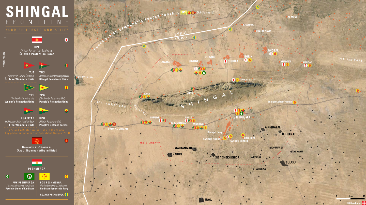
MAP
https://imagopyrenaei.files.wordpress.com/2016/05/shingal-front-forces.png
- Very good map. Shame we cannot use it for control purposes. TheNavigatrr (talk) 21:39, 9 April 2017 (UTC)
Roads
Adding the major roads/highways might be a good idea
- See User talk:Tradedia#Iraq location map road overlay Tradediatalk 02:36, 6 April 2017 (UTC)
- Someone should get this working for the individual map. It would be great to see it everywhere. TheNavigatrr (talk) 21:40, 9 April 2017 (UTC)
Garma is ISIS-held
Garma (northeast of Fallujah) is ISIS-held based on a report from the reliable Institute for the Study of War: "...the sub-district Garma in eastern Anbar remains under ISIS control". It couldn't be any clearer than that. Garma should be changed from red to black.
- Not anymore, ISF and allies recaptured it. TheNavigatrr (talk) 21:42, 9 April 2017 (UTC)
Why Husaybah is red?
I really don't think, that Husaybah on the iraqi-syrian border is in the hands of the government... please put it back to black. In some news, there are reports about some explosions due to the rain in a certain town called Husaybah al-Scharqiyah ("East-Husaybah" - not eastern Husaybah), but it is surely not Husaybah on the border and surely not in possession of government. http://altaghier.tv/2015/10/29/الامطار-تفجر-35-بيتا-ملغما-وعشرات-العبوا
- This has now been fixed. TheNavigatrr (talk) 21:43, 9 April 2017 (UTC)
Fallujah Clashes done
The clashes in Fallujah city are done, and Daesh controls the city: https://www.washingtonpost.com/world/middle_east/is-the-islamic-state-losing-its-grip-on-fallujah/2016/02/20/c86adda2-7416-4cb8-9be5-4ec5d30d3882_story.html
Please change the city to black.
- Denied. Now Fallujah is government-held, so there's no need for fighting over it. TheNavigatrr (talk) 21:43, 9 April 2017 (UTC)
Kabisa
Kabisa (or Kubaysah) near Hit in Al Anbar is controlled by IS and is not encircled.
- This is actually not true. It is controlled by ISIS. Would you care to provide a source? TheNavigatrr (talk) 21:41, 9 April 2017 (UTC)
- It is not controlled by ISIS for over a year. This module is utter trash. Eg here is ISIS own video where they are targeting Iraqi military outpost at Kabisah plant https://twitter.com/worldonalert/status/819310076389445632 Akashat has been taken over by Jughraiyfa PMU back in October last year. Surrounding of Lake Thawra has been clared year ago. Euphrates basin up to Haditha is under Iraqi military control and not some here-and-there towns localted on Anbar main road under ISIS control. Hassan al-Maklaf and whole area around it is under Iraqi military control for 2 years now. ISIS in that province is hiding in mountains, not towns. Ridicolious EllsworthSK (talk) 16:46, 30 April 2017 (UTC)
Links for my edits
I've listed the articles I used for my edits here, because they were too long for the edit box. --Ahmedo Semsurî (talk) 19:44, 31 May 2017 (UTC)
YBŞ and PKK Controlled Areas
Several areas shown on the map as controled by the Kurdistan Regional Government are actually under the control of the PKK and allied militias (Sinjar Resistance Units, ect). This groups hold the town of Sinjar and the surrounding area as well as an area near Qandil. They act in opposition to the KRG.XavierGreen (talk) 17:49, 8 April 2017 (UTC)
- This is true. However, we do not have an appropriate color for them, and we want to make the map simpler. Also, force for control are more spotty. TheNavigatrr (talk) 21:38, 9 April 2017 (UTC)
- So pick a color, orange for instance.XavierGreen (talk) 20:02, 13 April 2017 (UTC)
- We need to keep in mind that there is also a combined Syrian-Iraqi map, and Syrian YPG and YBŞ should have a similar yellow color on it.
- So it would be more logic to change the color of the KDP-KRG to a more yellow-greenish color.
- Maybe we have to change Turkey allied KDP-KRG to Greenish Yellow, keep PUK-KRG to the present/ normal yellow and change YBS and YPG to a more orange-like yellow?
- But with YBŞ allied more to the Iraqi federal goverment, it is strange to represent the same as Turkey allied KDP-KRG.--Niele~enwiki (talk) 13:55, 13 May 2017 (UTC)
- So pick a color, orange for instance.XavierGreen (talk) 20:02, 13 April 2017 (UTC)
- PKK doesn't control territory, they just have a presence. But I personally think YBS should have an orange collor. KDP some greenish, PUK and Gorran yellow. We must do immediately. Beshogur (talk) 09:49, 28 May 2017 (UTC)
- Both KDP-, PUK Peshmergas and unaffiliated ones fight for Kurdistan Region, thus my opinion is that it would be wrong to differentiate between these. Also, bear in mind that the "border" between these two parties is very blurry - perhaps even impossible to find. KDP is present in Kirkuk city with PUK, while PUK has some Peshmergas in Sinjar with KDP. KDP control some towns in Kirkuk, for example Altun Kupri, which has no PUK presence. So, we would just make the map more complicated. --Ahmedo Semsurî (talk) 19:54, 31 May 2017 (UTC)
- Concerning YBS, perhaps a solution could be to change the color for SDF in the Syrian map as well? --Ahmedo Semsurî (talk) 19:59, 31 May 2017 (UTC)
Desert border crossings
Are we now marking all military bases on border as "border crossing". From what I know border crossings are official crossings that are are overseen by some force as only official point of entry for civilians. Umm Jaris, Tal Sufouq, Tawsin, Tarifoa or Baktal are not border crossings. They are former Iraqi border guards bases that are now either occupied by Peshmerga, PMU or no one. EllsworthSK (talk) 19:11, 19 June 2017 (UTC)
Orange dots?
What are the orange dots in Ninevah Province supposed to represent? 70.59.227.82 (talk) 16:18, 18 October 2017 (UTC)
- This is the Ezidixan autonomous region in West Sinjar administered by the Ezidixan People’s Council (EPC) and controlled by YBS and HPG units and was established with the help of Syrian YPG back in 2014.
- It officially declared autonomy under Iraqi federal law this summer. It fought against Barzani (and Turkey-supported) Rojava Peshmerga in Sinune a year ago, preventing KRG from entering west-Sinjar.--Niele~enwiki (talk) 09:18, 19 October 2017 (UTC)
Desperate need to split KDP and PUK control colours.
The map in northern Iraq has become unmappable without seperating PUK and KDP control.
Without this the situation becomes un-understandable and misleading for people watching the map.
I personally think:
- KDP should be a greenish yellow
- EPC (Sinjar Alliance, YBS,HPG,...) should be same yellow as Syrian SDF,YPG as they are supported and established by them.
- PUK needs to be an orangy yellow as they are at this moment closer to Iraqi government.
But without splitting KDP and PUK and merging YBS with SDF's colour, we will get completely stuck in trying to map the new situation.--Niele~enwiki (talk) 09:26, 19 October 2017 (UTC)
Kifri?
Is there a source that Kifri is now under Iraqi control? I reverted this change, and was reverted by User:Beshogur without explanation. Rob984 (talk) 14:58, 21 October 2017 (UTC)
- I added a source before. If you find Rudaw reporting that it's under Pesh control, then add. But you can't find any source. Beshogur (talk) 18:50, 21 October 2017 (UTC)
- I found the revision, and sorry but a random Twitter account with 500 followers is not a source. Please see WP:RELIABLESOURCE. You changed this less then a week ago so it does not have consensus. I have again reverted this unsourced change. Rob984 (talk) 14:22, 22 October 2017 (UTC)
Qandil
The Qandil mountains are marked on the map as under KRG control, but they are actually controlled by the PKK and PJAK and have been for many years. See [[23]], [[24]]XavierGreen (talk) 17:40, 29 October 2017 (UTC)
Desert villages changed without a source
why are desert villages in Al-Anbar governorate north of the euphrates river and desert villages west of Salaheddine governorate changed from ISIS controlled to Iraqi Government control,is there a reliable source for this change,because i am unaware of such an offensive occurring at this time.Alhanuty (talk) 17:48, 30 October 2017 (UTC)
- It was implied in a couple of other sources, including Twitter and a report cited in the main campaign article. The news source reported that ISIL only holds territory in Iraq's Anbar Province, between Rawa and the Syrian border, which means that ISIL no longer controls any territory at all in the Nineveh Governorate. LightandDark2000 (talk) 01:07, 6 November 2017 (UTC)
Ain Zalah Oil Field
The Ain Zalah Oil Field is currently depicted as being under Peshmerga control, along with a couple of neighboring villages. However, this report implies that the Peshmerga has already withdrawn from that district entirely? So who currently holds the Ain Zalah District? IF someone wants, feel free to change that area to Iraqi Government control. You can use this source if you want. LightandDark2000 (talk) 01:15, 6 November 2017 (UTC)