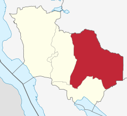
Mlele District is one of the five districts of the Katavi Region of Tanzania.
Mlele District | |
|---|---|
 Mlele District of Katavi Region | |
| Country | |
| Region | Katavi Region |
| Area | |
| • Total | 15,539 km2 (6,000 sq mi) |
| Population (2022 census) | |
| • Total | 118,818 |
| • Density | 7.6/km2 (20/sq mi) |
Mlele District was formed in 2012 out of part of Mpanda District. The population in 2022 was 118,818.[1]
Administrative subdivisions
editMlele District is administratively divided into twenty-three wards:[2]
- Ikuba
- Ilela
- Inyonga
- Itenka
- Kapalala
- Kasansa
- Kasokola
- Kibaoni
- Litapunga
- Machimboni
- Magamba
- Majimoto
- Mamba
- Mbede
- Mtapenda
- Mwamapuli
- Nsekwa
- Nsimbo
- Sitalike
- Ugalla
- Urwira
- Usevya
- Utende
References
edit- ^ "Katavi (Region, Tanzania) - Population Statistics, Charts, Map and Location". www.citypopulation.de. Retrieved 2024-02-09.
- ^ "Postcodes: Katavi Region 500000" (PDF). Archived from the original (PDF) on 2012-08-28. Retrieved 2012-08-28.
6°35′24″S 31°45′54″E / 6.590°S 31.765°E