Manslagt is a village in the region of East Frisia, in Lower Saxony, Germany. It is part of the municipality of Krummhörn. The village is located between Pilsum and Groothusen.
Manslagt | |
|---|---|
_IMG_6638.jpg) | |
 Coat of arms | |
Location of Manslagt  | |
 Manslagt  Manslagt | |
| Coordinates: 53°27′28″N 7°03′43″E / 53.45769°N 7.06199°E | |
| Country | Germany |
| State | Lower Saxony |
| District | Aurich |
| Municipality | Krummhörn |
| Area | |
| • Metro | 8.65 km2 (3.34 sq mi) |
| Elevation | 1 m (3 ft) |
| Population | |
| • Metro | 410 |
| Time zone | UTC+01:00 (CET) |
| • Summer (DST) | UTC+02:00 (CEST) |
| Postal codes | 26736 |
| Dialling codes | 04923 |
Manslagt was historically located on an island in the former Bay of Sielmönken and was built on a warft. It was first mentioned around the 11th century.[1] The Church of Manslagt dates from around 1400.[2]
Gallery edit
-
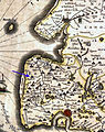 Location of Manslagt on a map by Ubbo Emmius, 1600
 -
 Houses in Manslagt
 -
 Former school, now kindergarten
 -
 Bronze model of Manslagt
.jpg)


Notable people edit
- Klaus Immer (1924–2022), politician
References edit
- ^ "Manslagt". Wierden en terpen (in Dutch). Retrieved 17 October 2023.
- ^ "Evangelische-Reformierte Kirche Manslagt". Krummhörn Greetsiel (in German). Retrieved 17 October 2023.
External links edit
![]() Media related to Manslagt at Wikimedia Commons
Media related to Manslagt at Wikimedia Commons