| Place name
|
Place #
|
Location
|
Suburb or Town
|
Co-ordinates
|
Built
|
Stateregistered
|
Photo
|
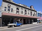
| Barkly Theatre
|
H0878
|
277-287 Barkly St
|
Footscray
|
37°47′58″S 144°53′41″E / 37.799530°S 144.894740°E / -37.799530; 144.894740
|
1914
|
28 August 1991
|
|
| CSR Sugar Refinery Complex
|
H1311
|
265 Whitehall St
|
Yarraville
|
37°49′09″S 144°54′16″E / 37.819230°S 144.904490°E / -37.819230; 144.904490
|
1872-73
|
8 May 1997
|
|
| Ercildoune
|
H0494
|
66 Napier St
|
Footscray
|
37°48′15″S 144°54′07″E / 37.804110°S 144.901870°E / -37.804110; 144.901870
|
1876
|
26 August 1981
|

|
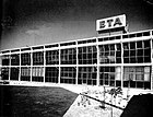
| ETA Foods Factory
|
H1916
|
254 Ballarat Rd
|
Braybrook
|
37°46′47″S 144°51′33″E / 37.779860°S 144.859130°E / -37.779860; 144.859130
|
1961
|
31 May 2001
|
|
| Footscray Park
|
H1220
|
4-68 Ballarat Rd
|
Footscray
|
37°47′38″S 144°54′20″E / 37.793850°S 144.905630°E / -37.793850; 144.905630
|
1911
|
21 November 1996
|

|
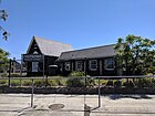
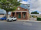
| Footscray Primary School
|
H1713
|
100 Geelong Road
|
Footscray
|
37°47′54″S 144°53′33″E / 37.798200°S 144.892600°E / -37.798200; 144.892600
|
1868
|
20 August 1982
|
|
| Footscray railway station
|
H1563
|
Irving and Hyde Sts
|
Footscray
|
37°48′09″S 144°54′05″E / 37.802450°S 144.901290°E / -37.802450; 144.901290
|
1900
|
20 August 1982
|

|
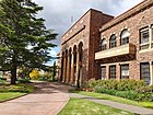
| Footscray Town Hall
|
H1218
|
61 Napier St
|
Footscray
|
37°48′16″S 144°54′02″E / 37.804500°S 144.900660°E / -37.804500; 144.900660
|
1936
|
21 November 1996
|
|
| Henderson House
|
H0183
|
43-45 Moreland St
|
Footscray
|
37°48′11″S 144°54′27″E / 37.803030°S 144.907600°E / -37.803030; 144.907600
|
1872-73
|
9 October 1974
|
|
| Interlocking Railway Crossing Gates
|
H1028
|
Anderson St
|
Yarraville
|
37°48′59″S 144°53′23″E / 37.816460°S 144.889680°E / -37.816460; 144.889680
|
1890
|
29 September 1994
|

|
| Jack's Magazine
|
H1154
|
off La Scala Ave
|
Maribyrnong
|
37°46′54″S 144°53′43″E / 37.781640°S 144.895380°E / -37.781640; 144.895380
|
1876-78
|
18 April 1996
|

|
| Kariwara District Scout Headquarters
|
H1343
|
4 Hyde St
|
Footscray
|
37°48′13″S 144°54′05″E / 37.803490°S 144.901460°E / -37.803490; 144.901460
|
1925-29
|
4 September 1997
|
|
| Kinnears Ropeworks
|
H2067
|
124-188 Ballarat Rd
|
Footscray
|
37°47′30″S 144°53′33″E / 37.791720°S 144.892480°E / -37.791720; 144.892480
|
1909
|
3 March 2005
|

|
| Maribyrnong Migrant Hostel
|
H2190
|
61-71 Hampstead Rd
|
Maidstone
|
37°46′34″S 144°52′37″E / 37.775980°S 144.876990°E / -37.775980; 144.876990
|
1942
|
12 February 2009
|
|
| Maribyrnong Tram Substation
|
H2321
|
149A and 149B Raleigh Rd
|
Maribyrnong
|
37°46′14″S 144°53′05″E / 37.770620°S 144.884710°E / -37.770620; 144.884710
|
1941-42
|
12 December 2013
|
|
| Pipemakers Park Complex
|
H1503
|
2 Van Ness Ave
|
Maribyrnong
|
37°46′35″S 144°53′40″E / 37.776250°S 144.894560°E / -37.776250; 144.894560
|
1868
|
20 August 1982
|
|
| Royal Australian Field Artillery Barracks
|
H1098
|
Wests Rd,
Ordnance Reserve
and Waterford Ave
|
Maribyrnong
|
37°46′24″S 144°52′51″E / 37.773210°S 144.880840°E / -37.773210; 144.880840
|
1911
|
5 October 1995
|
|
| Saltwater River Crossing Site and Footscray Wharves Precinct
|
H1397
|
west bank of the Maribyrnong River
|
Footscray
|
37°48′05″S 144°54′30″E / 37.801360°S 144.908410°E / -37.801360; 144.908410
|
1800s
|
11 December 1997
|
|
| Saltwater River Rail Bridge
|
H1213
|
over the Maribyrnong River
|
Footscray and
West Melbourne
|
37°47′54″S 144°54′58″E / 37.798200°S 144.916210°E / -37.798200; 144.916210
|
1858-59
|
24 October 1996
|

|
| State Savings Bank Building
|
H0723
|
13 Ballarat St
|
Yarraville
|
37°48′59″S 144°53′28″E / 37.816350°S 144.891200°E / -37.816350; 144.891200
|
1909
|
22 February 1989
|
|
| Sun Theatre
|
H0679
|
6-12 Ballarat St
|
Footscray
|
37°48′58″S 144°53′27″E / 37.816000°S 144.890700°E / -37.816000; 144.890700
|
1938
|
23 December 1987
|

|
| The Pebbles
|
H1308
|
57A Droop St
|
Footscray
|
37°47′47″S 144°53′47″E / 37.796360°S 144.896390°E / -37.796360; 144.896390
|
1920
|
16 October 1997
|

|
.jpg)
.jpg)


.jpg)

.jpg)


.jpg)


