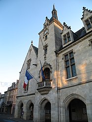
Libourne (French pronunciation: [libuʁn] ; Gascon: Liborna [liˈbuɾnɔ]) is a commune in the Gironde department in Nouvelle-Aquitaine in southwestern France. It is a sub-prefecture of the department.
Libourne | |
|---|---|
Subprefecture and commune | |
 Town hall | |
| Coordinates: 44°55′N 0°14′W / 44.92°N 0.24°W | |
| Country | France |
| Region | Nouvelle-Aquitaine |
| Department | Gironde |
| Arrondissement | Libourne |
| Canton | Le Libournais-Fronsadais |
| Intercommunality | CA Libournais |
| Government | |
| • Mayor (2020–2026) | Philippe Buisson[1] (PS) |
| Area 1 | 20.63 km2 (7.97 sq mi) |
| Population (2021)[2] | 24,557 |
| • Density | 1,200/km2 (3,100/sq mi) |
| Time zone | UTC+01:00 (CET) |
| • Summer (DST) | UTC+02:00 (CEST) |
| INSEE/Postal code | 33243 /33500 |
| Elevation | 2–28 m (6.6–91.9 ft) (avg. 15 m or 49 ft) |
| 1 French Land Register data, which excludes lakes, ponds, glaciers > 1 km2 (0.386 sq mi or 247 acres) and river estuaries. | |
It is the wine-making capital of northern Gironde and lies near Saint-Émilion and Pomerol.

Geography
editLibourne is located at the confluence of the Isle and Dordogne rivers. Libourne station has rail connections to Bordeaux, Bergerac, Angoulême, Périgueux, Limoges, Brive-la-Gaillarde and Sarlat-la-Canéda.
History
editIn 1270, Leybornia was founded as a bastide by Roger de Leybourne (of Leybourne, Kent), an English seneschal of Gascony, under the authority of King Edward I of England. It suffered considerably in the struggles of the French and English for the possession of Gironde in the 14th century, and joined France in the 15th century.
In December 1854 John Stuart Mill passed through Libourne, remarking "I stopped at Libourne as I intended & had a walk about it this morning quite the best thing there is the bridge of the Dordogne, the view from which is really fine".[3]
Population
edit
|
| ||||||||||||||||||||||||||||||||||||||||||||||||||||||||||||||||||||||||||||||||||||||||||||||||||||||||||||||||||
| |||||||||||||||||||||||||||||||||||||||||||||||||||||||||||||||||||||||||||||||||||||||||||||||||||||||||||||||||||
| Source: EHESS[4] and INSEE (1968-2017)[5] | |||||||||||||||||||||||||||||||||||||||||||||||||||||||||||||||||||||||||||||||||||||||||||||||||||||||||||||||||||
Sights
editThe Gothic church, restored in the 19th century, has a stone spire 232 ft (71 m) high. On the quay there is a machicolated clock-tower which is a survival of the defensive walls of the 14th century. The town-house, containing a small museum and a library, is a quaint relic of the 16th century. It is located by the main square, the Place Abel Surchamp, which hosts every weekend one of the largest fresh food market in the region. There is a statue of Élie, duc Decazes, who was born in the region.
Notable people
edit- Eugène Atget (1857–1927), French photographer, "Creator and Purveyor of a Collection of Photographic Views of Old France"
- Florian Latorre (born 1997), racing driver
- Louis Le Provost de Launay (1850–1912), French deputy and senator
- Jean-Marie Londeix (1932–), French saxophonist
- Jean Marcadé (1920–2012), French Hellenist and historian
- Jean-Marie Poumeyrol, (born 1946), artist
See also
edit- Hull town walls, the town of Hull, also established under Edward I, is said to have been similar in design to the Bastides, in particular Libourne
- Communes of the Gironde department
- Keynsham, twinned with Libourne
References
edit- ^ "Répertoire national des élus: les maires". data.gouv.fr, Plateforme ouverte des données publiques françaises (in French). 2 December 2020.
- ^ "Populations légales 2021" (in French). The National Institute of Statistics and Economic Studies. 28 December 2023.
- ^ The Collected Works of John Stuart Mill Vol XIV, Page 251. ISBN 0-8020-5261-4
- ^ Des villages de Cassini aux communes d'aujourd'hui: Commune data sheet Libourne, EHESS (in French).
- ^ Population en historique depuis 1968, INSEE
External links
edit- . Encyclopædia Britannica. Vol. 16 (11th ed.). 1911.
- Official website (in French)
- Unofficial website (in French)


