Lake Pukaki (Māori: Pūkaki)[4][5][6] is the largest of three roughly parallel alpine lakes running north–south along the northern edge of the Mackenzie Basin on New Zealand's South Island. The others are Lakes Tekapo and Ōhau. All three lakes were formed when the terminal moraines of receding glaciers blocked their respective valleys, forming moraine-dammed lakes. The Alps2Ocean mountain bike trail follows the edge of Lake Pukaki for part of its length.
| Lake Pukaki | |
|---|---|
| Māori: Pūkaki | |
 Lake Pukaki | |
 | |
.png) Lake Pukaki | |
| Location | Mackenzie District, Canterbury region, South Island |
| Coordinates | 44°07′S 170°10′E / 44.117°S 170.167°E |
| Primary inflows | Tasman River |
| Primary outflows | Pukaki River |
| Catchment area | 1,413 km2 (546 sq mi)[1] |
| Basin countries | New Zealand |
| Surface area | 178.7 km2 (69.0 sq mi)[1] |
| Average depth | 47 m (154 ft)[1] |
| Max. depth | 70 m (230 ft)[1] |
| Water volume | 4.66 km3 (3,780,000 acre⋅ft)[1] |
| Surface elevation | 518.2 to 532 m (1,700 to 1,745 ft)[2] |
| Frozen | never (winter air temperatures can reach as low as −20 °C (−4 °F) though)[3] |
| Islands | Morgans Island |
| Settlements | Twizel |
| References | [1][2] |
Geography
editThe glacial feed to the lakes gives them a distinctive blue colour, created by glacial flour, the extremely finely ground rock particles from the glaciers. Lake Pukaki covers an area of 178.7 km2 (69.0 sq mi), and the surface elevation of the lake normally ranges from 518.2 to 532 metres (1,700 to 1,745 ft) above sea level.[2]
The lake is fed at its northern end by the braided Tasman River, which has its source in the Tasman and Hooker Glaciers, close to Aoraki / Mount Cook. To the west of Lake Pukaki lies the Ben Ohau mountain range with Ben Dhu (1,607 metres; 5,272 ft) and Betty Hill (1,601 metres; 5,253 ft) closest to the lake. On the eastern side there is some farmland on the flatter contours between Lake Pukaki and Lake Tekapo.
Good views of the taller mountains in Aoraki /Mount Cook National Park, 70 kilometres (43 mi) to the north can be had from the southern shore of the lake.
Tahr statue
editThere is a life size bronze statue of a Himalayan Tahr standing upon a boulder near the visitor centre on the southern shores of Lake Pukaki, This was the site of a protest by hunters fighting against the Department of Conservation’s controversial tahr culling programme in 2020.[7]
Hydroelectricity
editThe lake is now part of the Waitaki hydroelectric scheme. The lake's original outflow was at its southern end, into the Pukaki River. The outflow has been dammed, and canals carry water from Lake Pukaki and Lake Ōhau through the Ōhau A power station to Lake Ruataniwha.
Pukaki is also fed by the waters of Lake Tekapo, which are diverted through a canal to a power station on Pukaki's eastern shore (Tekapo B station). The lake has been raised twice to increase storage capacity (by 9 metres (30 ft) in 1952, and 37 metres (121 ft) in 1976),[8] submerging Five Pound Note Island, which once appeared on New Zealand's five pound note. The current lake has an operating range of 13.8 metres (45 ft) (the level within which it can be artificially raised or lowered), giving it an energy storage capacity of 1,595 GWh. Along with Lake Tekapo's 770 GWh storage, it provides over half New Zealand's hydroelectricity storage capacity. In September 2012, Environment Canterbury approved a change in conditions of Meridian Energy's resource consent controlling the water levels and flows of Lake Pukaki. The change allows Meridian to lower the lake a further five metres (16 ft) from the minimum level of 518 metres (1,699 ft) above sea level in the event of an energy crisis.[9]
-
 Lake Pukaki, looking towards Mount Cook, in summer
 -
 Statue of the Himalayan Tahr, introduced to New Zealand in 1904
 -
 Plaque providing details about the introduction of the tahr
 -
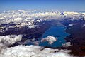 Aerial view of Lake Pukaki (2015)


Nearby settlements
editThere was previously a seasonal Ngāi Tahu food-gathering settlement on the southern shore of Lake Pukaki called Punatahu.[10][11]: 37
The closest town to Lake Pukaki is Twizel, 7 kilometres (4.3 mi) to the south of the lake and Tekapo is 47 km (32 minutes drive) to the northeast. State Highway 8 skirts the southern end of the lake, and State Highway 80 runs north along the length of its western shore, to Mount Cook Village in the Aoraki / Mount Cook National Park.
The nearby Pukaki Scientific Reserve is home to the Nationally Endangered moth species Izatha psychra.[12]
Road safety
editState Highway 8 runs along the edge of Lake Pukaki. Numerous crashes have occurred here as drivers have come around a blind corner, seen Lake Pukaki and wanted to stop at an unsafe location to enjoy the view.[13][14][15][16]
2020 fire
editA significant scrub fire burnt on the shores of Lake Pukaki in August 2020. Both State Highway 8 and SH80 were closed. Firefighters fought the fire with 14 monsoon bucket equipped helicopters, two fixed-wing aircraft, and 10 fire engines.[17] The fire destroyed 3500 hectares and took 12 days to put out. $1 million was spent fighting it.[18] Environmentalists believe that the spread of wilding pines in the Mackenzie District along with the dry conditions allowed the scrub fire to become so destructive.[19]
Pukaki Scientific Reserve
editThe Pukaki Scientific Reserve is a small scientific reserve of 32 hectares (79 acres) located on the western side of Lake Pukaki next to the Mount Cook road. The Pukaki Scientific Reserve is home to the endangered Izatha psychra moth.[20] The Lake Pukaki area is also home to the "Data Deficient" fly species Anabarhynchus albipennis.[21][22]
Climate
edit| Climate data for Lake Pukaki, elevation 556 m (1,824 ft), (1971–2000) | |||||||||||||
|---|---|---|---|---|---|---|---|---|---|---|---|---|---|
| Month | Jan | Feb | Mar | Apr | May | Jun | Jul | Aug | Sep | Oct | Nov | Dec | Year |
| Mean daily maximum °C (°F) | 22.0 (71.6) |
22.4 (72.3) |
19.3 (66.7) |
15.3 (59.5) |
10.9 (51.6) |
6.5 (43.7) |
6.2 (43.2) |
8.5 (47.3) |
12.3 (54.1) |
15.0 (59.0) |
17.4 (63.3) |
19.7 (67.5) |
14.6 (58.3) |
| Daily mean °C (°F) | 15.9 (60.6) |
16.0 (60.8) |
13.6 (56.5) |
10.2 (50.4) |
6.4 (43.5) |
2.7 (36.9) |
2.3 (36.1) |
4.1 (39.4) |
7.3 (45.1) |
9.8 (49.6) |
11.9 (53.4) |
14.0 (57.2) |
9.5 (49.1) |
| Mean daily minimum °C (°F) | 9.7 (49.5) |
9.6 (49.3) |
7.9 (46.2) |
5.2 (41.4) |
1.9 (35.4) |
−1.1 (30.0) |
−1.7 (28.9) |
−0.3 (31.5) |
2.2 (36.0) |
4.5 (40.1) |
6.3 (43.3) |
8.3 (46.9) |
4.4 (39.9) |
| Average rainfall mm (inches) | 60.0 (2.36) |
41.0 (1.61) |
60.0 (2.36) |
58.0 (2.28) |
56.0 (2.20) |
45.0 (1.77) |
51.0 (2.01) |
43.0 (1.69) |
64.0 (2.52) |
65.0 (2.56) |
72.0 (2.83) |
58.0 (2.28) |
673 (26.47) |
| Source: CliFlo (rain 1951–1980)[23] | |||||||||||||
References
edit- ^ a b c d e f Irwin, J. (September 1978). "Bottom sediments of Lake Tekapo compared with adjacent Lakes Pukaki and Ohau, South Island, New Zealand". N.Z. Journal of Marine and Freshwater Research. 12 (3): 245–250. doi:10.1080/00288330.1978.9515749.

- ^ a b c "Pukaki Lake Levels". Meridian Energy Limited. Retrieved 2008-03-09.
- ^ Tom Hunt (23 June 2015). "New Zealand drops to 20C below freezing". Stuff. Retrieved 2016-09-16.
- ^ Multiple sources:J.H., Beattie (1945). "Maori Lore of Lake, Alp and Fiord". Otago Daily Times. Dunedin, New Zealand. pp. P14, 15, 16 & 38.
- ^ "Visit – Lake Pūkaki". Mackenzie Region, New Zealand. Archived from the original on 2023-02-02. Retrieved 2023-11-15.
- ^ "Nohoanga Site Information Sheet" (PDF). Te Rūnanga o Ngāi Tahu. August 2020. Retrieved 15 November 2023.
- ^ "Tahr Jam protest to go ahead at Lake Pukaki". Stuff. 2020-07-12. Retrieved 2020-09-21.
- ^ Five Pound Note Island - Lake Pukaki, N.Z.
- ^ Lttlewood, Matthew (28 September 2012). "Meridian get freedom to lower lake". Stuff.co.nz. The Timaru Herald. Retrieved 2016-09-16.
- ^ J.H, Beattie (1945). "Maori Lore of Lake, Alp and Fiord". Otago Daily Times. Dunedin, New Zealand. p. 15.
- ^ "Aoraki/Mount Cook National Park Management Plan (draft)" (PDF). 2018. p. 37. Archived (PDF) from the original on 22 September 2023. Retrieved 2024-01-30.
- ^ Hoare, Robert J. B. (2010). "Izatha (Insecta: Lepidoptera: Gelechioidea: Oecophoridae)" (PDF). Fauna of New Zealand. 65: 1–201. Archived from the original (PDF) on 2019-01-26. Retrieved 2019-04-12.
- ^ "New $150,000 safe stopping area for crash prone road near Lake Pukaki". Stuff. 2017-09-14. Retrieved 2020-09-21.
- ^ "Multiple calls to 'police comms' before fatal crash in Lake Pukaki". Stuff. 2017-07-05. Retrieved 2020-09-21.
- ^ "Tourists took wrong turn before plunging off cliff into lake". Stuff. 2016-03-14. Retrieved 2020-09-21.
- ^ "Two people seriously injured in crash near Lake Pukaki". Stuff. 2020-07-26. Retrieved 2020-09-21.
- ^ "Aoraki/Mt Cook evacuated in the face of massive Mackenzie District scrubfire". Stuff. 2020-08-30. Retrieved 2021-03-20.
- ^ "Lake Pukaki fire: Cost of firefighting revealed". NZ Herald. Retrieved 2021-03-20.
- ^ "Huge burning glow in the sky at uncontrolled fire near Aoraki/Mt Cook". RNZ. 2020-09-01. Retrieved 2021-03-20.
- ^ "Narrow escape for critically endangered Canterbury moth". Stuff. 2021-03-04. Retrieved 2021-03-20.
- ^ I. G. Andrew; R. P. Macfarlane; P. M. Johns; R. A. Hitchmough; I. A.N. Stringer (21 June 2012). "The conservation status of New Zealand Diptera". New Zealand Entomologist. 35 (2): 99–102. doi:10.1080/00779962.2012.686312. ISSN 0077-9962. Wikidata Q54666021.
- ^ Leif Lyneborg (4 March 1992). "Therevidae (Insecta: Diptera)" (PDF). Fauna of New Zealand. 24. Department of Scientific and Industrial Research: 23–24. doi:10.7931/J2/FNZ.24. ISSN 0111-5383. OCLC 716136809. Wikidata Q45069389.
- ^ "CliFlo – National Climate Database : Lake Pukaki M.W.D." NIWA. Retrieved 10 May 2024.
Further reading
edit- Irwin, J. (1972). "Sediments of Lake Pukaki, South Island, New Zealand". New Zealand Journal of Marine and Freshwater Research. 6 (4): 482–491. doi:10.1080/00288330.1972.9515442.
External links
edit- Department of Conservation – Mackenzie Basin short walks