Lake Mackay, known as Wilkinkarra to the Indigenous Pintupi people, is the largest of hundreds of ephemeral salt lakes scattered throughout the Pilbara and northern parts of the Goldfields-Esperance region of Western Australia[1] and the Northern Territory. It is located on the edge of the Great Sandy Desert.
| Lake Mackay (Wilkinkarra) | |
|---|---|
| Wilkinkarra (Pintupi-Luritja) | |
 From space (November 1989) | |
 Lake Mackay (Wilkinkarra) Location on the Northern Territory and Western Australian border | |
| Location | Western Australia and Northern Territory |
| Coordinates | 22°30′S 128°35′E / 22.500°S 128.583°E |
| Type | Salt lake |
| Basin countries | Australia |
| Max. length | 100 km (62 mi) |
| Max. width | 100 km (62 mi) |
| Surface area | 3,494 km2 (1,349 sq mi) |
 | |
The lake is the largest in Western Australia and has a surface area of 3,494 square kilometres (1,349 sq mi).[2] Its elevation ranges between 355 m (1,165 ft) and 370 m (1,210 ft) above mean sea-level.[3]
Description edit
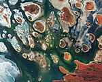
Lake Mackay is the fourth largest lake in Australia.[4] It measures approximately 100 kilometres (60 mi) east-west and north-south. The darker areas of the lakebed are indicative of some form of desert vegetation or algae, some moisture within the soils of the dry lake, and the lowest elevations where pooling of water occurs. In this arid environment, salts and other minerals are carried to the surface through capillary action caused by evaporation, thereby producing the white reflective surface. Visible are various brown hills scattered across the eastern half of the lake and east-west-oriented sand ridges south of the lake.
Encounters edit
Explorer David Carnegie in 1897 predicted the lake's existence when he passed by it to the west as quoted in his book Spinifex and Sand.[5]
May 9th we left the well on a Southerly course, and were soon amongst the ridges, which continued for the next two days. The night of the 11th, having skirted a line of rough cliffs, we camped about three miles North of a very prominent single hill, which I named Mount Webb, after W. F. Webb, Esq., of Newstead Abbey, Nottinghamshire. As the sun rose that morning the mirage of a lake of apparently great size was visible for 90° of the horizon — that is, from East round to South. Neither from the cliffs that we skirted, nor from Mount Webb, was any lake visible, but it is more than probable that a large salt lake exists in this locality, possibly connecting, in a broken line, Lake White and Lake Macdonald.[citation needed]
The lake was first charted by Christopher Walker. He and Andy Everett came upon the mid-eastern side on Tuesday 15 April 1913, while on a prospecting expedition west from Ryan's Well to Wiluna.
Looking westward all that I could see was mirage for miles which appeared like large sheets of water. … After leaving the hill & going west for two miles we struck on our right an arm of the lake. At this point the lake was dry & exposed a thin layer of very white salt. … We then followed the arm of the lake westward. In another two miles along the arm it wheeled around to the south. … From this position looking north at what first looked like land on the other side, was only an island in the lake. Going a little further south gave us a better view of the islands. These islands would be distant from near shore from one up to four miles. Looking westward between the islands the lake could plainly be seen for many miles westward. This part of the lake we could not see water only large salt plains, which had the appearance of a large plain after a snow storm.[6]
It was next reported by the 1930 Mackay Aerial Survey Expedition, after the survey aircraft flew over on 5 June 1930. Then Michael Terry and party reached the north-eastern corner of Lake Mackay by camel in August 1932.[7] Terry mentioned two reports which may have been of the same lake, prior to Mackay’s 1930 survey: Afghan cameleer Rawazan in 1904, and the prospector Jimmy Wyckham in 1925.[6]
Lake Mackay was approved as a name both in the Northern Territory and in Western Australia by the Minister for the Interior, Canberra, on 13 March 1934[8] after Donald George Mackay.
Events edit
The lake was the birthplace of prominent Indigenous artist Linda Syddick Napaltjarri,[9] and the area in which artist Ronnie Tjampitjinpa grew up.[10]
Namesakes edit
The Northern Territory locality of Lake Mackay, whose boundaries include the lake, was named after it in 2007.[11]
Mackay Lacus, one of the lakes on Saturn's moon Titan, is named after Lake Mackay.[12]
Gallery edit
-
 2017 satellite photograph taken by Copernicus Sentinel-2B

See also edit
References edit
- ^ "Largest Waterbodies". Geoscience Australia. 15 May 2014. Retrieved 15 March 2015.
- ^ "Australian Geoscience - Largest Waterbodies". 2009. Archived from the original on 26 February 2009. Retrieved 7 March 2009.
- ^ Geoscience Australia elevation data portal
- ^ Northern Territory Department of Land Resource Management, Information Page - Lake Mackay Archived 21 March 2015 at the Wayback Machine
- ^ "Spinifex and Sand".
- ^ a b Long, Jeremy; Nash, David, eds. (2022). "Appendix 4: Lake Mackay". Diary -- Walker Bros Prospecting Expedition 1913. Carlisle, WA: Hesperian Press. pp. 123–132. ISBN 978-0-85905-727-1.
- ^ 21 August 1932 entry, camp 35. Log of Michael Terry leader of the Emu Mining Company expedition 1932. Transcribed by Brian A. Rutherford, 5 November 1994. SA Museum Archives AA 333/6/4 A-C. http://archives.samuseum.sa.gov.au/aa333/AA%20333-06.htm
- ^ Department of Lands Planning and the Environment, Northern Territory Government. "Lake Mackay". NT Place Names Register. Retrieved 2 May 2023.
- ^ Birnberg, Margo; Janusz Kreczmanski (2004). Aboriginal Artist Dictionary of Biographies: Australian Western, Central Desert and Kimberley Region. Marleston, South Australia: J.B. Publishing. p. 216. ISBN 1-876622-47-4.
- ^ McCulloch, Alan; Susan McCulloch; Emily McCulloch Childs (2006). The new McCulloch's Encyclopedia of Australian Art. Fitzroy, Victoria: Aus Art Editions in association with The Miegunyah Press. p. 159. ISBN 0-522-85317-X.
- ^ "Place Names Register Extract for Lake Mackay (locality)". NT Place Names Register. Northern Territory Government. Retrieved 13 January 2020.
- ^ "Mackay Lacus". USGS planetary nomenclature page]. USGS. Retrieved 28 December 2013.