Konkandiva Fort (transliteration: Konkandiva Qilа̄) is a fort located 70 km from Pune in Maharashtra. This fort is on the boundary of Raigad and Pune district. The fort was important as a surveillance fort to keep watch on the possible attack on the Raigad fort through Ghol Village side along the Mutha river.[1]
| Konkandiva Fort | |
|---|---|
| Part of Sahyadri Hill Range | |
| Raigad district, Maharashtra | |
 Konkandiva fort | |
 Konkandiva Fort  Konkandiva Fort | |
| Coordinates | 18°17′39.2″N 73°25′21.8″E / 18.294222°N 73.422722°E |
| Type | Hill fort |
| Height | 2953 Ft. |
| Site information | |
| Owner | Government of India |
| Controlled by |
|
| Open to the public | Yes |
| Condition | Ruins |
| Site history | |
| Materials | Stone |
How to reach
editThere are two routes to reach the fort. The route from Konkan region is tough and the nearest town is Mahad which is 61 km from Mumbai. The base village of the fort is Sandoshi which is 32 km from Mahad. There are good hotels at Mahad. The trekking path passes through the kavlya ghat hillock north of the Sandoshi. The second route starts from Village Gajarewadi which is near Ghol in Pune district. This route is very safe and wide. Both the routes meet at a col on the northern side of the fort. The trek path is then steep and requires efforts to climb in rainy season.[2] The villagers from the local village Gajrewadi make night stay and food arrangements at a reasonable cost.
Places to see
editThere is a cave and a few rock-cut water cisterns on the fort to be seen.
Gallery
edit-
 Rockcut water cistern
 -
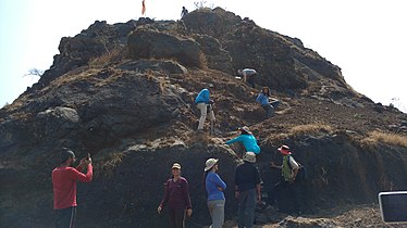 Climbing the last rock patch
 -
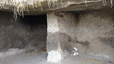 Rockcut caves on the fort


See also
editReferences
edit- ^ "Konkan Diva Fort Trek Near Pune". web1.abmra.in. Retrieved 2018-12-09.
- ^ "Kokandiwa, Raigad District, Western Ghats, India, Adventure, Trekking". trekshitiz.com. Retrieved 2018-12-09.