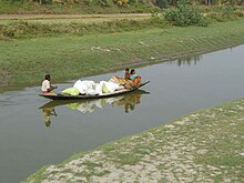
Jamuna River is a tributary of the Ichamati River. It originates from Hoogly River at Char Jadubati located opposite to Tribeni. It flows through Nadia and North 24 Parganas districts of West Bengal and is one of the major rivers of the North 24 Parganas district.
| Jamuna River | |
|---|---|
 River Jamuna at Charghat | |
| Location | |
| Country | India |
| State | West Bengal |
| District | North 24 Parganas, Nadia |
| Physical characteristics | |
| Source | Char Jadubati, Hooghly River |
| • location | West Bengal, India |
| • coordinates | 22.990568,88.409563 |
| Mouth | Ichamati River |
• location | West Bengal, India |
History and Origin edit
It is said that the Hooghly River divided into three streams at Tribeni in Hooghly district : the present Hooghly River (also known as Bhagirathi), the Saraswati River which flows south-west beyond Saptagram and the Jamuna River (which flowed south-east). However, in the course of time, the connection between the Hooghly and the Jamuna, north of the present day Kalyani town, silted up and it caused the latter to emerge out as a separate river.
As of now, it originates near the Haringhata Farm in southern Nadia district. As a whole, the river is characterized by sharp bends and meandering courses. It flows through the towns of Haringhata, Nagarukhra, Gaighata, Gobardanga, Machlandapur and Charghat and finally merges with the Ichamati River. During its flow, it passes through several landmarks such as the Indian Institute of Science Education and Research, West Bengal,Nagarukhra New Market-Complex Area(Nimtala Rd), Gaighata Burning Ghat, Gobardanga Grameen Hospital, Gobardanga Children's Hospital, Gobardanga Rajbari etc.,Gobardanga Hindu college.
While mentioning Tribeni and the surrounding areas in his Manshamangal, Bengali poet Bipradas Pipilai gave an account of the river in Manshamangal. As the merchant ship of the trader Chand Saudagar preceded to the sea, he passed through Tribeni and Saptagram and the tri junction of the Hooghly, Saraswati and Jamuna. He wrote “ Ganga aar Saraswati, Jamuna bishal oti”(the Ganges and Saraswati, the Jamuna so large). This line tells us about the largeness of the river during that time.[1][2]
References edit
2)https://indiariversblog.files.wordpress.com/2017/03/west-bengal.pdf
26°06′N 92°45′E / 26.100°N 92.750°E
- ^ Self citated from Google Maps
- ^ Mallick, Sarmistha. "LAND FORM AND CHANNEL CHARACTERISTICS OF JAMUNA RIVER BASIN, WEST BENGAL".
{{cite journal}}: Cite journal requires|journal=(help)