Iceberg Peak (9,149 feet (2,789 m)) is located in the Lewis Range, Glacier National Park in the U.S. state of Montana.[3] Iceberg Peak rises more than 3,000 feet (910 m) above Iceberg Lake and is considered a difficult climb due to the steepness and exposure climbers must endure.[4] The peak sits astride the continental divide 1.1 mi (1.8 km) WNW of Mount Wilbur.[1]
| Iceberg Peak | |
|---|---|
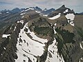
 Iceberg Peak above Iceberg lake | |
| Highest point | |
| Elevation | 9,149 ft (2,789 m) |
| Prominence | 905 ft (276 m)[1] |
| Coordinates | 48°48′52″N 113°45′36″W / 48.81444°N 113.76000°W[2] |
| Geography | |
 Iceberg Peak Location in Montana  Iceberg Peak Location in the United States | |
| Location | Glacier National Park Glacier County / Flathead County Montana, U.S. |
| Parent range | Lewis Range |
| Topo map | USGS Ahern Pass |
| Climbing | |
| Easiest route | class 3-4 |
Climate edit
Based on the Köppen climate classification, the peak is located in an alpine subarctic climate zone with long, cold, snowy winters, and cool to warm summers.[5] Temperatures can drop below −10 °F with wind chill factors below −30 °F.
Geology edit
Like other mountains in Glacier National Park, the peak is composed of sedimentary rock laid down during the Precambrian to Jurassic periods. Formed in shallow seas, this sedimentary rock was initially uplifted beginning 170 million years ago when the Lewis Overthrust fault pushed an enormous slab of precambrian rocks 3 mi (4.8 km) thick, 50 miles (80 km) wide and 160 miles (260 km) long over younger rock of the cretaceous period.[6]
Gallery edit
-
 Mount Wilbur (left), Iceberg Peak, B-7 Pillar (right)
 -
 Iceberg Lake Trail with Iceberg Peak (left) and B-7 Pillar (right)
 -
 Iceberg Peak's south aspect in upper right, seen from Swiftcurrent Mountain.
 -
 Iceberg Peak (right), aerial view circa 1925.


See also edit
References edit
- ^ a b "Iceberg Peak, Montana". Peakbagger.com. Retrieved 2010-05-02.
- ^ "Iceberg Peak". Geographic Names Information System. United States Geological Survey, United States Department of the Interior. Retrieved 2010-09-26.
- ^ Ahern Pass, MT (Map). TopoQwest (United States Geological Survey Maps). Retrieved June 15, 2018.
- ^ "Iceberg Peak". SummitPost. Retrieved 2010-05-02.
- ^ Peel, M. C.; Finlayson, B. L.; McMahon, T. A. (2007). "Updated world map of the Köppen−Geiger climate classification". Hydrol. Earth Syst. Sci. 11: 1633–1644. ISSN 1027-5606.
- ^ Gadd, Ben (2008). "Geology of the Rocky Mountains and Columbias".
{{cite journal}}: Cite journal requires|journal=(help)
This Flathead County, Montana state location article is a stub. You can help Wikipedia by expanding it. |
This Glacier County, Montana state location article is a stub. You can help Wikipedia by expanding it. |