Hurumlandet is a peninsula in AKershus county, Norway. It is situated west of the Oslofjord and east of the Drammensfjord. It comprises the southern parts of the municipality Asker. It is connected to Follo through the subsea Oslofjord Tunnel. Before 1990, Hurumlandet was the planned location for the new Oslo Airport. Ultimately, the airport was allocated to Gardermoen.[1]

History
editSince the Middle Ages, Hurumlandet was a strategic headland at the entrance to the country's capital. Militarily the peninsula has been of great importance and fortifications date since the Middle Ages. West at the Drammenfjord are fortifications from the 1890s.[2]
Geography
editThe bedrock is very varied with the remains of an ancient volcano in the central and Ersvika and a lot of red granite in key areas. Hurum municipality consists mostly of granite deposits in the west and center parties, with deposits of shale and sandstone in a belt in the south and east. In the south there are also some limestone and a raised section of Ordovician, and started rock and quartzite parties.
Nature preserves
editHurum country has a disproportionate number of protected natural areas, due to the very rich and diverse biology on the peninsula. Hurum country has coastal coniferous forest and a rich fauna, particularly on the island of Tofteholmen. Wildlife includes moose, osprey, cormorant and eider.[3]
In the south there are eight nature reserves - Holtnesdalen (deciduous forests), Solfjellåsene (limestone habitats), Haraldsfjellet (limestone habitats), Sandbukta-Østnestangen (vegetation), Ersvikskjær (bird), Tofteskogen (forest), Ranvikholmen (plant) and Tofteholmen (plant). Further to the northeast lies Storskjær outside Sætre. [4] [5] [6] [7] [8] [9] [10] [11]
Gallery
edit-
 Holtnesdalen Nature Reserve
 -
 Ersvikskjær Nature Reserve
 -
 Sandbukta-Østnestangen Nature Reserv
 -
 Ranvikholmen Nature Reserve
 -
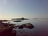
 Tofteholmen Nature Reserve


References
edit- ^ "Hurumlandet rundt (Reiselivet i Drammensregionen)". Archived from the original on 2011-07-26. Retrieved 2011-05-26.
- ^ Geir Thorsnæs. "Hurumlandet". Store norske leksikon. Retrieved October 1, 2017.
- ^ Geir Thorsnæs. "Tofteholmen". Store norske leksikon. Retrieved October 1, 2017.
- ^ "Holtnesdalen naturreservat" (PDF). fylkesmannen.no. Retrieved October 1, 2017.
- ^ "Solfjellåsene naturreservat". naturbase.no. Retrieved October 1, 2017.
- ^ "Haraldsfjellet naturreservat". naturbase.no. Retrieved October 1, 2017.
- ^ "Sandbukta-Østnestangen naturreservat". fylkesmannen.no. Retrieved October 1, 2017.
- ^ "Tofteskogen naturreservat". naturbase.no. Retrieved October 1, 2017.
- ^ "Ranvikholmen naturreservat". oslofjorden.org. Retrieved October 1, 2017.
- ^ "Tofteholmen naturreservat". naturbase.no. Retrieved October 1, 2017.
- ^ "Storskjær naturreservat" (PDF). naturbase.no. Retrieved October 1, 2017.
59°32′24″N 10°29′31″E / 59.54000°N 10.49194°E
This Akershus location article is a stub. You can help Wikipedia by expanding it. |