Horkstow Bridge is a suspension bridge that spans the New River Ancholme near the village of Horkstow in North Lincolnshire. It was designed by Sir John Rennie as part of the River Ancholme Drainage Scheme, completed in 1836, and is a Grade II* listed building.
Horkstow Bridge | |
|---|---|
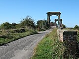
 Viewed from field below raised riverbank | |
| Coordinates | 53°39′31″N 0°31′41″W / 53.6585°N 0.5280°W |
| Crosses | New River Ancholme |
| Locale | North Lincolnshire |
| Maintained by | Environment Agency |
| Heritage status | UK Grade II* listed building |
| Characteristics | |
| Design | Suspension |
| Material | Wrought iron, timber |
| Total length | 42.6 m (140 ft) |
| Width | 4.3 m (14 ft) |
| No. of spans | 1 |
| Load limit | 5 t |
| Clearance below | 4.7 m (15 ft 5 in) |
| History | |
| Designer | Sir John Rennie |
| Construction end | 1836 |
| Location | |
 | |
History and description
editRiver Ancholme | |||||||||||||||||||||||||||||||||||||||||||||||||||||||||||||||||||||||||||||||||||||||||||||||||||||||||||||||||||||||||||||||||||||||||||||||||||||||||||||||||||||||||||||||||||||||||||||||||||||||||||||||||||||||||||||||||||||||||||||||||||||||||||||||||||||||||||||||||||||||||||||||||||||||||||||||||||||||||||||||||||||||||||||||||||||||
|---|---|---|---|---|---|---|---|---|---|---|---|---|---|---|---|---|---|---|---|---|---|---|---|---|---|---|---|---|---|---|---|---|---|---|---|---|---|---|---|---|---|---|---|---|---|---|---|---|---|---|---|---|---|---|---|---|---|---|---|---|---|---|---|---|---|---|---|---|---|---|---|---|---|---|---|---|---|---|---|---|---|---|---|---|---|---|---|---|---|---|---|---|---|---|---|---|---|---|---|---|---|---|---|---|---|---|---|---|---|---|---|---|---|---|---|---|---|---|---|---|---|---|---|---|---|---|---|---|---|---|---|---|---|---|---|---|---|---|---|---|---|---|---|---|---|---|---|---|---|---|---|---|---|---|---|---|---|---|---|---|---|---|---|---|---|---|---|---|---|---|---|---|---|---|---|---|---|---|---|---|---|---|---|---|---|---|---|---|---|---|---|---|---|---|---|---|---|---|---|---|---|---|---|---|---|---|---|---|---|---|---|---|---|---|---|---|---|---|---|---|---|---|---|---|---|---|---|---|---|---|---|---|---|---|---|---|---|---|---|---|---|---|---|---|---|---|---|---|---|---|---|---|---|---|---|---|---|---|---|---|---|---|---|---|---|---|---|---|---|---|---|---|---|---|---|---|---|---|---|---|---|---|---|---|---|---|---|---|---|---|---|---|---|---|---|---|---|---|---|---|---|---|---|---|---|---|---|---|---|---|---|---|---|---|---|---|---|---|---|---|---|---|---|---|---|---|---|---|---|---|---|---|---|---|---|---|---|---|---|---|---|---|---|
| |||||||||||||||||||||||||||||||||||||||||||||||||||||||||||||||||||||||||||||||||||||||||||||||||||||||||||||||||||||||||||||||||||||||||||||||||||||||||||||||||||||||||||||||||||||||||||||||||||||||||||||||||||||||||||||||||||||||||||||||||||||||||||||||||||||||||||||||||||||||||||||||||||||||||||||||||||||||||||||||||||||||||||||||||||||||
The River Ancholme rises south of Bishopbridge in Lincolnshire, flows northwards through the town of Brigg and the Ancholme Level, an area of fenland, and enters the Humber at Ferriby Sluice. Attempts were made to drain the wetland and improve the navigability of the river as early as the 13th century, and in the 1630s Sir John Monson constructed the first sluice gates near South Ferriby and a new straight channel, the Ancholme Navigation, to drain the Level and protect the town of Brigg from flooding. A 1767 Act of Parliament authorised works towards "the more effectual draining the Lands lying in the Level of Ancholme" and making the river navigable as high as Bishopbridge, to be financed by a land tax and the imposition of tolls on goods carried. Two further Acts followed to enlarge the powers of the first. Under the 1825 Act, Sir John Rennie proposed the New River Ancholme Drainage Scheme, by which the navigation, or New River Ancholme, was straightened, widened and deepened, existing small bridges with many arches were replaced by single-span structures, and the locks at Ferriby Sluice were enlarged.[1][2][3]
Horkstow Bridge, the only suspension bridge designed by Rennie,[4] is one of several bridges built as part of that project. The ironwork was supplied by Messrs John and Edward Walker of Gospel Oak Ironworks, Tipton, Staffordshire, and the bridge was completed in 1836 under the supervision of site engineer Adam Smith.[1][4] At each end of the bridge are rusticated stone piers in the form of 6.5 m (21 ft) towers which form archways above the road. The single span measures 42.6 m (140 ft) from centre to centre of the masonry towers and the entrance to the bridge deck through the archways is 3.5 m (11 ft) wide. The deck is 4.3 m (14 ft) wide between the rails, surfaced with wooden planks, supported by timber crossbeams suspended from double wrought-iron chains, and is distinctly arched.[5][6] At normal water levels there is 4.7 m (15 ft 5 in) clearance beneath the bridge.[7]
It is about 1.1 miles (1.8 km) upstream from Ferriby Sluice[8] and links the villages of Horkstow, east of the river, and Winterton on the west. A ferry had previously connected the villages, and it is believed a bridge had occupied the site from the 18th century, providing access to the brick-making kilns located on the Winterton side.[6][9] The bridge is open to vehicles, but movement can be felt even under pedestrian traffic. It can be approached from the east via Bridge Lane, a narrow road which leaves the B1204 just north of Horkstow, but on the west bank only a dirt track remains.[10]
Horkstow is one of "only a handful" of early suspension bridges in Britain to remain as originally designed, but it has not survived completely unscathed.[5] In 1979, repairs were needed after the tractor unit of a 23-ton articulated lorry fell through into the river, destroying a quarter of the bridge deck and damaging the attached suspension rods, though the rest of the structure remained intact.[5] In the 1990s, the bridge was strengthened – the deck relaid using a tropical hardwood timber to support a 5 t load and the underground parts of the suspension chains replaced with high-tensile bars – while retaining its appearance and functionality.[6][9] The works earned engineers C Spencer Ltd a commendation in the 1999 Institution of Civil Engineers Historic Bridge Awards.[9][11]
Although open to motor traffic, it is mostly used by ramblers, cyclists and anglers.[10] It is owned by the Environment Agency,[9] and in September 1979 was listed at Grade II*,[4] a grading which covers "particularly important buildings of more than special interest".[12] The site of the former brickyard is a Site of Nature Conservation Interest.[6]
References
edit- ^ a b Rennie, Sir John, Pres.Inst.C.E. (1845). "No. 715. An account of the Drainage of the Level of Ancholme, Lincolnshire.". In Manby, Charles, F.G.S (ed.). Minutes of proceedings of the Institution of Civil Engineers. Vol. 4. Institution of Civil Engineers. pp. 198–99.
{{cite book}}: CS1 maint: multiple names: authors list (link) - ^ Priestley, Joseph (1831). Historical account of the navigable rivers, canals, and railways, throughout Great Britain (reprint). Jim Shead. pp. 20–23. Retrieved 29 July 2011.
- ^ Fisher, Nigel (31 December 1999). "Brigg Town History". Scunthorpe Telegraph. Brigg Town Council. Archived from the original (reprint) on 12 October 2010.
- ^ a b c "Horkstow Suspension Bridge". Heritage Gateway. Retrieved 29 July 2011.
- ^ a b c Labrum, E. A., ed. (1 February 1993). Civil engineering heritage, eastern and central England. Thomas Telford. pp. 48–51. ISBN 0-7277-1970-X.
- ^ a b c d Ambarchian, H. (2000). "Horkstow Suspension Bridge". In Ryall, M. J.; Harding, J. E.; Parke, G. A. R. (eds.). Bridge management 4: inspection, maintenance, assessment and repair. Thomas Telford. pp. 696–98. ISBN 978-0-7277-2854-8.
- ^ "River Ancholme". Jim Shead. Retrieved 27 September 2009.
- ^ a b c d "Treasure trove of best in district". Scunthorpe Telegraph. 3 March 2009. p. 6.
- ^ a b "Horkstow Bridge – North Lincolnshire". North Lincolnshire Community Website. Retrieved 27 September 2009.
- ^ "History in the remaking". New Civil Engineer. EMAP. 18 November 1999. Retrieved 27 September 2009.
- ^ "Listed Buildings". English Heritage. 2010. Archived from the original on 26 January 2013. Retrieved 19 August 2011.
Gallery
edit-
 Approached via Bridge Lane from the east
 -
 Deck and western arch
 -
 Approached from the west
 -
 From beneath, showing crossbeams and hangers


