You can help expand this article with text translated from the corresponding article in Japanese. Click [show] for important translation instructions.
|
Hokkaidō Koma-ga-take (北海道駒ヶ岳, Hokkaidō Koma-ga-take), also Oshima Koma-ga-take (渡島駒ヶ岳), Oshima Fuji (渡島富士), or just Koma-ga-take (駒ヶ岳) is a 1,131 metres (3,711 ft) andesitic stratovolcano[1] on the border between Mori, Shikabe, and Nanae, all within the Oshima Subprefecture of Hokkaidō, Japan.
| Mount Hokkaidō-Komagatake | |
|---|---|
| 北海道駒ヶ岳 | |
 View from Lake Ōnuma (August 2008) | |
| Highest point | |
| Elevation | 1,131 m (3,711 ft) |
| Listing | List of mountains and hills of Japan by height List of volcanoes in Japan |
| Coordinates | 42°03′48″N 140°40′38″E / 42.06333°N 140.67722°E |
| Naming | |
| Language of name | Japanese |
| Geography | |
| Topo map | Geographical Survey Institute 25000:1 駒ヶ岳 50000:1 室蘭 |
| Geology | |
| Age of rock | Quaternary |
| Mountain type | stratovolcano |
| Volcanic arc/belt | Northeastern Japan Arc |
| Last eruption | September to November 2000 |

Occurrence of volcanic activity started some 30,000 years ago. Following roughly 5,000 years of dormancy, volcanic activity at Mount Koma-ga-take restarted in 1640,[2] triggering the Kan'ei Great Famine.[citation needed] Since then, there have been at least 50 recorded volcanic events at Mount Koma-ga-take.[3]
-
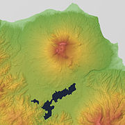 Relief Map
 -
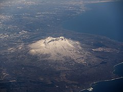
 Viewed from NW.
 -
 Viewed from ESE.


See also edit
References edit
- ^ "HOKKAIDO KOMA-GA-TAKE". Quaternary Volcanoes of Japan. Geological Survey of Japan, AIST. 2006. Archived from the original on 2012-12-19. Retrieved 2009-06-22.
- ^ Takahashi, Ryo (March 2022). "Mineralogical and geochemical investigations for subvolcanic hydrothermal alteration environments at an active volcano: An example of Hokkaido-Komagatake volcano, Japan". Journal of Volcanology and Geothermal Research. 423. Bibcode:2022JVGR..42307497T. doi:10.1016/j.jvolgeores.2022.107497. S2CID 246616567. Retrieved January 10, 2024.
- ^ 神沼克伊,小山悦郎 日本の火山を科学する 日本列島津々浦々、あなたの身近にある108の活火山とは? ソフトバンククリエイティブ 2011. ISBN 978-4797361308.
- Geographical Survey Institute
- Teikoku's Complete Atlas of Japan, Teikoku Shoin Co., Ltd., Tokyo 1990, ISBN 4-8071-0004-1
External links edit
 Media related to Mount Hokkaido-Koma at Wikimedia Commons
- Hokkaido-Komagatake - Japan Meteorological Agency (in Japanese)
- "Hokkaido-Komagatake: National catalogue of the active volcanoes in Japan" (PDF). - Japan Meteorological Agency
- Hokkaido-Komagatake Volcano - Geological Survey of Japan
- Hokkaido-Komagatake - Smithsonian Institution: Global Volcanism Program
This Hokkaidō location article is a stub. You can help Wikipedia by expanding it. |