Hillsdale is a suburb in the Eastern Suburbs of Sydney, in the state of New South Wales, Australia. Hillsdale is located 6 kilometres south-east of the Sydney central business district in the Bayside Council. The suburb is named after Pat Hills, former Deputy Premier of New South Wales.[citation needed]
| Hillsdale Sydney, New South Wales | |||||||||||||||
|---|---|---|---|---|---|---|---|---|---|---|---|---|---|---|---|
 View of Hillsdale from Eastgardens Shopping Centre | |||||||||||||||
 | |||||||||||||||
| Population | 5,501 (2016 census)[1] | ||||||||||||||
| • Density | 7,900/km2 (20,400/sq mi) | ||||||||||||||
| Postcode(s) | 2036 | ||||||||||||||
| Area | 0.7 km2 (0.3 sq mi) | ||||||||||||||
| Location | 6 km (4 mi) south-east of Sydney CBD | ||||||||||||||
| LGA(s) | Bayside Council | ||||||||||||||
| State electorate(s) | Maroubra | ||||||||||||||
| Federal division(s) | Kingsford Smith | ||||||||||||||
| |||||||||||||||
Retail edit
Hillsdale has a shopping centre called Southpoint Shopping Centre (formerly known as Hillsdale Town Centre) on Bunnerong Road, which is a high-rise mixed-use complex with commercial and residential space and is opposite the large Heffron Park. Southpoint is anchored by TK Maxx, Aldi, Woolworths and a large Australia Post office.
Recreation edit
Heffron Park, at 44 hectares it is the largest sporting reserve in Randwick City. A range of sports are played in the park through winter and summer including netball, rugby league, soccer, touch football, oz tag, cricket, cycling, tennis and gymnastics. Located on the south-east corner of the park is the Des Renford Leisure Centre, a council-owned gym, aquatic and fitness centre.[2]
The park is popular with local residents for walking, jogging and cycling. The Hensley Athletic Field is located on Wentworth Avenue, close to Botany and the Westfield Eastgardens shopping centre. Matraville Public School is located in Hillsdale at the corner of Bunnerong and Beauchamp Roads.
History edit
Hillsdale was part of the suburb of Matraville until the 1960s. Matraville was originally reserved for the Church and Schools Corporation with income generated intended to support clergy and teachers. It reverted to the crown in 1917 and was allocated for a settlement for soldiers returning from World War I. The suburb was split between Randwick and Botany Councils. When problems arose from the division in 1961, Botany Council decided to rename its portion Gilmore, to honour Australian poet Dame Mary Gilmore (1864–1962). After the post masters general office pointed out that there already was a Gilmore, New South Wales, the council chose Hillsdale to honour Patrick Darcy Hills, who was the New South Wales minister for local government. It was a controversial choice since most residents believed that a name should have been chosen that reflected Australia's history.[3]
Many homes were built in Hillsdale after World War II including some by the Housing Commission.
Demographics edit
At the 2016 census, there were 5,501 residents in Hillsdale. The most common country of birth was Australia (39.9%), with the top other countries of birth being Bangladesh 5.8%, China 4.7%, Philippines 3.8%, Iraq 3.3% and India 2.9%. 39.6% of people spoke only English at home. Other languages spoken at home included Bengali 7.5%, Spanish 4.4%, Assyrian Neo-Aramaic 4.2%, Mandarin 3.9% and Cantonese 3.3%. The top responses for religious affiliation were Catholic 26.5%, No Religion 20.7%, Not stated 11.7% and Islam 11.6%,. The majority of dwellings were units or apartments and there were few separate or semi-detached houses in the suburb.[1]
Education edit
Matraville Public School is a primary school in Hillsdale, drawing its students predominantly from the surrounding suburbs of Hillsdale, Banksmeadow and Matraville. In 2007 the school had approximately 300 students from kindergarten to Year 6. The school opened as Cross Road Public School in 1903, named after the school's location at the intersection between Beauchamp and Bunnerong Roads. It was renamed as Matraville Public School in 1904.[4]
Housing edit
Housing in Hillsdale is primarily units or flats, with few detached dwellings. More than half the households in Hillsdale rent, significantly higher than the Sydney average.[5]
About 2% of Hillsdale is public housing[6]
Transport edit
There are about 4 bus stops in the suburb of Hillsdale. The nearest train station is the Domestic Airport railway station in Mascot and it is 5 km from Hillsdale. The nearest light rail stop the Juniors Kingsford light rail stop in Kingsford and it is about 3.3 km from Hillsdale.
Gallery edit
-
 Southpoint Shopping Centre, Bunnerong Road
 -
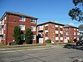 Characteristic three-storey blocks of home units, Unsted Crescent
 -
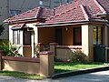 Characteristic detached cottage, Rhodes Street


References edit
- ^ a b Australian Bureau of Statistics (27 June 2017). "Hillsdale". 2016 Census QuickStats. Retrieved 28 December 2018.
- ^ http://www.randwick.nsw.gov.au/planning-and-building/council-works-and-upgrades/major-projects/heffron-park-plan-of-management [bare URL]
- ^ The Book of Sydney Suburbs, Compiled by Frances Pollon, Angus & Robertson Publishers, 1990, p.123, ISBN 0-207-14495-8
- ^ "Matraville Public School". NSW Department of Education and Training. Retrieved 30 October 2007.
- ^ "Hillsdale Profile". Retrieved 23 November 2011.
- ^ ago, MattH • 10 months (29 April 2020). "10 Sydney Suburbs with the most Housing Commission". Sydney Suburb Reviews. Retrieved 23 February 2021.
{{cite web}}: CS1 maint: numeric names: authors list (link)