Halidzor (Armenian: Հալիձոր) is a village in the Tatev Municipality of the Syunik Province in Armenia.
Halidzor
Հալիձոր | |
|---|---|
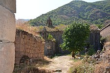
.jpg) Village view from Wings of Tatev | |
 Halidzor  Halidzor | |
| Coordinates: 39°24′37″N 46°17′43″E / 39.41028°N 46.29528°E | |
| Country | Armenia |
| Province | Syunik |
| Municipality | Tatev |
| Population | |
| • Total | 551 |
| Time zone | UTC+4 (AMT) |
| Halidzor at GEOnet Names Server | |
The settlement has a rich history and is adorned with historical monuments. Positioned strategically on the international stage, it is home to one of the most prominent landmarks in the Republic of Armenia - the Tatev Monastery Complex, situated on the edge of the Vorotan gorge. It stands as the first stop of the world's longest ropeway, the Tatev Aerial Tramway.
It has a beautiful nature, characterized by lush forests, deep canyons, and picturesque mountain ranges, through which the fast-flowing Vorotan River winds its way.
Etymology of the name edit
The name "Halidzor" originates from the names of the settlements called Hale, Halis in Haband province.[3]
Geography edit
Geographically, Halidzor is located near the left bank of the Vorotan River, at an altitude of 1300-1350 m above sea level. The regional center of Syunik province - the city of Kapan, is 62 km away. The nearest town is Goris, which is 12 km to the southwest.[4]
To the northeast of Halidzor is the village of Shinuhayr, to the South and East is the gorge of the Vorotan river, to the East and northeast are cultivated fields.
History edit
In the historical sources Halidzor is mentioned from the beginning of the 10th century.[3] In his book of "History of Syunik" Stepanos Orbelyan ranks the settlement among medium-sized villages according to the tax it paid.[5]
In the 10th century, Hamazaspuhi, the daughter of Prince Babden of Syunik, donated the village of Halidzor to the Tatev monastery, which was confirmed by Tarsayich Orbelyan in 1274.[3][5] Halidzor was considered Tatev's property until the 19th century.
In St. Orbelyan and old records, the name of the village is written as HALE. Until the late Middle Ages, when writing Halidzor, the gorge around the village was understood (in Armenian: dzor= ձոր, means a gorge). Later it was written Hali-dzor and finally Halidzor.
Soviet period edit
During the Soviet years, Halidzor was part of the Zangezur province of the Armenian SSR, and from 1930, it was part of the Goris region.
The current village was built in 1966, a little far from the Old Halidzor, and until 1991 it was part of the Soviet economy of Harzhis.
Period of the Independent Republic of Armenia edit
In the early years of the independence of the Republic of Armenia, Halidzor was included in the Goris region, and since 1995 in the Syunik province, which includes the former Goris region. Since 2015, the settlement has been included in the enlarged Tatev Municipality of Syunik province.
Historical and Cultural Monuments edit
The standing church of Saint Minas, built in 1611, is located in the old village of Halidzor. 2 km southwest of the village is the famous Harants Desert, in the vicinity are the church called "Khachin Khut", the "Poghos-Petros" chapel, a number of old settlements: "Halidzor", "Karmir", "Haykashen", "Haykatap", Hale, Old Shenategh (Old Settlement), as well as the cemetery with many khachkars. On the left bank of Vorotan, in the gardens, there is a preserved inscription erected on a rock in 1265. Harsnadzor observation point is one of the most visited historical and cultural monuments of Halidzor.
Demographics edit
Population edit
The Statistical Committee of Armenia reported its population was 707 in 2010,[6] up from 602 at the 2001 census.[7]
Features edit
The village hosts a station of the Wings of Tatev - the world's longest non-stop double track aerial tramway.
Economy edit
The population is engaged in farming, gardening, animal husbandry and beekeeping.
Gallery edit
-
 Syunyats Mets Anapat
 -
 Bell tower-chapel in Halidzor
 -
 View of the village
 -
 Saint Minas Church
 -
 Wings of Tatev Tram
 -
 The remains of the old Halidzor settlement
 -
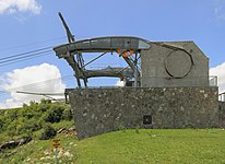 Wings of Tatev Halidzor station
 -
 Syunyats Mets Anapat


.jpg)


.jpg)

References edit
- ^ Statistical Committee of Armenia. "The results of the 2011 Population Census of Armenia" (PDF).
- ^ "Syunik regional e-Governance System" (in Armenian). Syunik Province provincial government. Click on link entitled "Համայնքներ" (community) and search for the place by Armenian name.
- ^ a b c Barkhudaryan, S. G. (1960). Codex of Armenian inscriptions, volume 2 (in Armenian). Yerevan: ASSR, Academy of Science. p. 51.
- ^ Dictionary of settlements of the Republic of Armenia (in Armenian). Yerevan: "GEODESY AND CARTOGRAPHY" State Non-Commercial Organization (SNCO). 2008. p. 116.
- ^ a b Orbelyan, Stepanos. History of Syunik (in Armenian).
- ^ "Marzes of Armenia and Yerevan City in Figures, 2010" (PDF). Statistical Committee of Armenia.
- ^ Report of the results of the 2001 Armenian Census, Statistical Committee of Armenia
This article about a location in Syunik Province, Armenia is a stub. You can help Wikipedia by expanding it. |