Hacienda Kankabchén is located in the Tixkokob Municipality in the state of Yucatán in southeastern Mexico. It is one of the properties that arose during the nineteenth century henequen boom. There are numerous other properties of this name in the Yucatán including Hacienda Kancabchén in Baca, Hacienda Kancabchén (Halachó), Hacienda Kancabchén (Homún), Hacienda Kancabchén (Motul), Hacienda Kankabchén (Seyé), Hacienda Kancabchén (Tunkás), Hacienda Kancabchén Ucí and Hacienda Kancabchén de Valencia.
Hacienda Kankabchén | |
|---|---|
Private residence | |
,_Yucat%C3%A1n_(01).JPG) Entrance to Hacienda Kankabchén, Tixkokob, Yucatán | |
 Hacienda Kankabchén Location in Mexico | |
| Coordinates: 21°02′36″N 89°22′59″W / 21.04333°N 89.38306°W | |
| Country | Mexico |
| Mexican States | Yucatán |
| Municipalities | Tixkokob |
| Time zone | UTC−6 (CST) |
| • Summer (DST) | UTC−5 (CDT) |
| Postal code | 97473[1] |
| Area code | 991[2] |
Toponymy
editThe name (Kancabchén) is a word from the Mayan language meaning the well of the red ground.[3]
How to get there
editAt the east side of Mérida, from the Periférico, take Calle 65 approximately 19 km to Tixkokob. Then go 5 km north on Calle 18 to Hacienda Kankabchén.[4]
History
editArchitecture
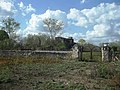
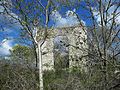
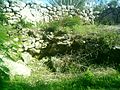
editAs is evident from photographs, the architectural structures have decayed and no habitable buildings remain.
Demographics
editAll of the henequen plantations ceased to exist as autonomous communities with the agrarian land reform implemented by President Lazaro Cardenas in 1937. His decree turned the haciendas into collective ejidos, leaving only 150 hectares to the former landowners for use as private property.[5] Figures before 1937 indicate populations living on the farm. After 1937, figures indicate those living in the community, as the remaining Hacienda Kankabchén houses only the owner's immediate family.
According to the 2005 census conducted by the INEGI, there is no permanent population residing in the area.[6]
| Year | 1900 | 1910 | 1921 | 1930 | 1940 | 1950 | 1960 | 1970 | 1980 | 1990 | 1995 | 2000 | 2005 |
|---|---|---|---|---|---|---|---|---|---|---|---|---|---|
| Population | 217 | 268 | 119 | 121 | 82 | 86 | 73 | 93 | 8 | ? | ? | 0 | 0 |
References
edit- ^ "Consulta Códigos Postales". Servicio Postal Mexicano. Correos de México. Archived from the original on 28 July 2011. Retrieved 29 April 2015.
- ^ "Yucatan Mexico Telephone Area Codes". Travel Yucatan. Travel Yucatan. Retrieved 29 April 2015.
- ^ "Hacienda Kancabchén". Haciendas en Yucatan. Gobierno del Estado de Yucatán. Retrieved 3 May 2015.
- ^ "21°02′36"N, 89°22′59"W". LatLong. Get Latitude Longitude. Retrieved 3 June 2015.
- ^ Joseph, Gilbert Michael (1988). Revolution from without : Yucatán, Mexico, and the United States, 1880-1924 (Pbk. ed.). Durham: Duke University Press. p. 292. ISBN 0-8223-0822-3. Retrieved 29 April 2015.
- ^ "Principales resultados por localidad (ITER)". Instituto Nacional de Estadística y Geografía (in Spanish). Instituto Nacional de Estadística y Geografía. 2010. Retrieved 30 April 2015.
Bibliography
edit- Bracamonte, P and Solís, R., Los espacios de autonomía maya, Ed. UADY, Mérida, 1997.
- Gobierno del Estado de Yucatán, "Los municipios de Yucatán", 1988.
- Kurjack, Edward y Silvia Garza, Atlas arqueológico del Estado de Yucatán, Ed. INAH, 1980.
- Patch, Robert, La formación de las estancias y haciendas en Yucatán durante la colonia, Ed. UADY, 1976.
- Peón Ancona, J. F., "Las antiguas haciendas de Yucatán", en Diario de Yucatán, Mérida, 1971.
Photo gallery
edit-
 View of the Hacienda Kankabchén
 -
 View of the Hacienda Kankabchén
 -
 View of the Hacienda Kankabchén
 -
 View of the Hacienda Kankabchén
 -
 View of the Hacienda Kankabchén
 -
 View of the Hacienda Kankabchén
 -
 View of the Hacienda Kankabchén
 -
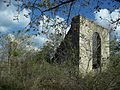 Church at Hacienda Kankabchén
 -
 Church at Hacienda Kankabchén
 -
 Church at Hacienda Kankabchén
 -
 Church at Hacienda Kankabchén
 -
 Grounds of the Hacienda Kankabchén
 -
 Mound at Hacienda Kankabchén
 -
 Grounds of the Hacienda Kankabchén
 -
 Henequen of Hacienda Kankabchén
 -
 Henequen of Hacienda Kankabchén
 -
 Road to the Hacienda Jesús María.
,_Yucat%C3%A1n_(02).JPG)
,_Yucat%C3%A1n_(03).JPG)
,_Yucat%C3%A1n_(04).JPG)
,_Yucat%C3%A1n_(05).JPG)
,_Yucat%C3%A1n_(06).JPG)
,_Yucat%C3%A1n_(07).JPG)
,_Yucat%C3%A1n_(08).JPG)
,_Yucat%C3%A1n_(09).JPG)
,_Yucat%C3%A1n_(10).JPG)
,_Yucat%C3%A1n_(11).JPG)
,_Yucat%C3%A1n_(12).JPG)
,_Yucat%C3%A1n_(13).JPG)
,_Yucat%C3%A1n_(14).JPG)
,_Yucat%C3%A1n_(15).JPG)
,_Yucat%C3%A1n_(16).JPG)
,_Yucat%C3%A1n_(17).JPG)
,_Yucat%C3%A1n_(18).JPG)