Habura (Rusyn: Габура; Hungarian: Laborcfő) is a village and municipality in the Medzilaborce District in the Prešov Region of far north-eastern Slovakia.
Habura | |
|---|---|
Municipality | |
 | |
 Habura Location of Habura in the Prešov Region  Habura Location of Habura in Slovakia | |
| Coordinates: 49°20′N 21°52′E / 49.333°N 21.867°E | |
| Country | |
| Region | Prešov |
| District | Medzilaborce |
| First mentioned | 1543 |
| Area | |
| • Total | 27.81[2] km2 (10.74[2] sq mi) |
| Elevation | 376[3] m (1,234[3] ft) |
| Population (2021) | |
| • Total | 462[1] |
| Time zone | UTC+1 (CET) |
| • Summer (DST) | UTC+2 (CEST) |
| Postal code | 067 52[3] |
| Area code | +421 57[3] |
| Car plate | ML |
| Website | www |
History
editIn historical records the village was first mentioned in 1543. Before the establishment of independent Czechoslovakia in 1918, it was part of Zemplén County within the Kingdom of Hungary.
Geography
editThe municipality lies at an altitude of 387 metres, and it covers an area of 27.82 km2. It has a population of about 470 people.
Genealogical resources
editThe records for genealogical research are available at the state archive "Statny Archiv in Presov, Slovakia"
- Greek Catholic church records (births/marriages/deaths): 1894-1896 (parish A)
Gallery
edit-
 Wooden Church of Saint Nicholas the Miracle-worker in Habura
 -
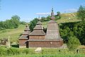 Wooden Church of Saint Nicholas in Habura
 -
 Wooden Church of Saint Nicholas in Habura (seen from the west)
 -
 Wooden Church of Saint Nicholas in Habura (seen from the east)
 -
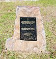 Dedication plaque next to the Church of Saint Nicholas in Habura
 -
 First written record of Habura from 1543
 -
 Memorial to WWII victims from Habura
 -
 Memorial to the Slovak National Uprising in Habura
 -
 Cpt. Ľudovít Kukorelli memorial bust in Habura
 -
 A street in Habura
 -
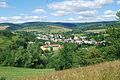 A view of Habura at noon (August 2016)
 -
 Small chapel, resting area and stopover of a local Slovak National Uprising educational trail
 -
 A statue of legendary early medieval prince Laborec on a hill near the village


.jpg)


See also
editReferences
edit- ^ "Počet obyvateľov podľa pohlavia – obce (ročne)". statistics.sk (in Slovak). Statistical Office of the Slovak Republic. 31 March 2022. Retrieved 31 March 2022.
- ^ a b "Hustota obyvateľstva – obce [om7014rr_ukaz: Rozloha (Štvorcový meter)]". statistics.sk (in Slovak). Statistical Office of the Slovak Republic. 31 March 2022. Retrieved 31 March 2022.
- ^ a b c d "Základná charakteristika". statistics.sk (in Slovak). Statistical Office of the Slovak Republic. 17 April 2015. Retrieved 31 March 2022.
- ^ a b "Hustota obyvateľstva – obce". statistics.sk (in Slovak). Statistical Office of the Slovak Republic. 31 March 2022. Retrieved 31 March 2022.
External links
edit Media related to Habura at Wikimedia Commons
- Official website

- http://www.statistics.sk/mosmis/eng/run.html Archived 16 November 2007 at the Wayback Machine
- Surnames of living people in Habura
This Prešov Region geography article is a stub. You can help Wikipedia by expanding it. |