Glastonbury is a rural town and locality in the Gympie Region, Queensland, Australia.[2][3] In the 2021 census, the locality of Glastonbury had a population of 365 people.[1]
| Glastonbury Queensland | |||||||||||||||
|---|---|---|---|---|---|---|---|---|---|---|---|---|---|---|---|
 Country road, Glastonbury | |||||||||||||||
 Glastonbury | |||||||||||||||
| Coordinates | 26°12′47″S 152°31′11″E / 26.2130°S 152.5197°E | ||||||||||||||
| Population | 365 (2021 census)[1] | ||||||||||||||
| • Density | 4.959/km2 (12.844/sq mi) | ||||||||||||||
| Postcode(s) | 4570 | ||||||||||||||
| Area | 73.6 km2 (28.4 sq mi) | ||||||||||||||
| Time zone | AEST (UTC+10:00) | ||||||||||||||
| Location | |||||||||||||||
| LGA(s) | Gympie Region | ||||||||||||||
| State electorate(s) | Gympie | ||||||||||||||
| Federal division(s) | Wide Bay | ||||||||||||||
| |||||||||||||||
Geography
editGreendale is a neighbourhood in the north of the locality (26°11′00″S 152°32′00″E / 26.1833°S 152.5333°E).[4]
History
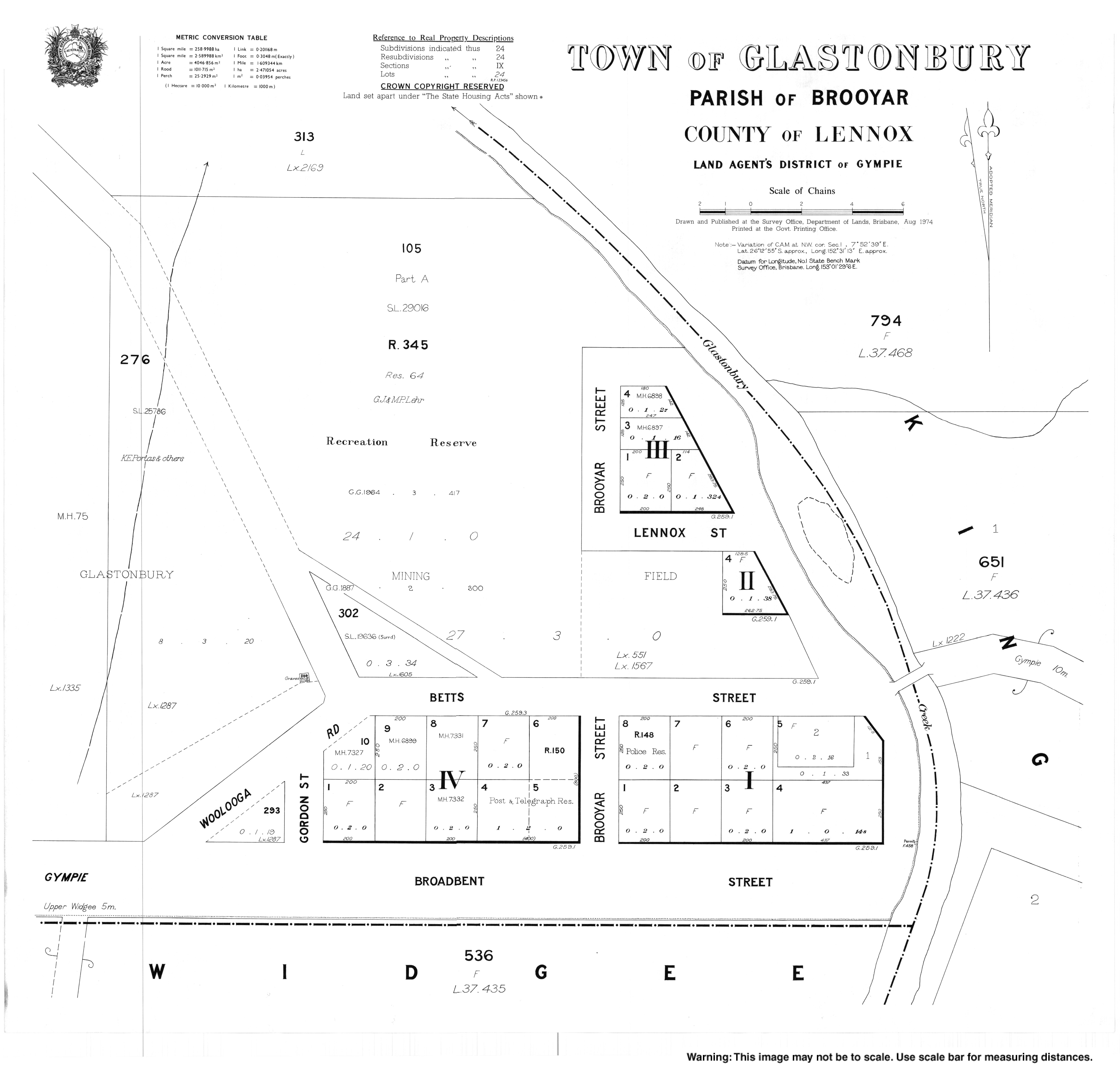
editGlastonbury Provisional School opened on 16 August 1879. On 1 January 1909, it became Glastonbury State School. It closed on 6 June 1960. It was also known as Glastonbury Creek State School.[5] It was on the western corner of intersection of Gordon Street, Betts Street, and Diggins Road (approx 26°12′47″S 152°31′02″E / 26.21296°S 152.51720°E).[6][7]
St Joseph's Catholic Church was a timber church built in 1911. In 1926, it was relocated to a more central location in Gordon Street (26°12′49″S 152°31′02″E / 26.213703°S 152.5173°E), where it was rededicated by Archbishop James Duhig.[8] In 1987, it was closed and sold and converted to a house.[9][10][11]
Glastonbury Hall was originally part of the Glastonbury Hotel. In 1931, the community bought the hall.[12]
Greendale Provisional School opened on 21 October 1930,[13] but closed in 1941. It reopened in 1947 and in 1948 became Greendale State School. It closed on 5 June 1960.[5] It was in Greendale near Glastonbury Creek (approx 26°10′43″S 152°31′32″E / 26.17868°S 152.52552°E).[7]
Demographics
editIn the 2016 census, the locality of Glastonbury had a population of 351 people.[14]
In the 2021 census, the locality of Glastonbury had a population of 365 people.[1]
Heritage listings
editGlastonbury has the following heritage sites:
- Glastonbury Hall, 1329 Glastonbury Road (26°12′49″S 152°31′16″E / 26.21370°S 152.52114°E)[12]
Education
editThere are no schools in Glastonbury. The nearest government primary school is Widgee State School in neighbouring Widgee to the west and Gympie South State School in Southside to the east. The nearest government secondary school is James Nash State High School in Gympie to the east. There are also non-government schools in Southside and Gympie.[15]
References
edit- ^ a b c Australian Bureau of Statistics (28 June 2022). "Glastonbury (SAL)". 2021 Census QuickStats. Retrieved 28 February 2023.
- ^ "Glastonbury – town in Gympie Region (entry 13893)". Queensland Place Names. Queensland Government. Retrieved 27 December 2020.
- ^ "Glastonbury – locality in Gympie Region (entry 46331)". Queensland Place Names. Queensland Government. Retrieved 27 December 2020.
- ^ "Greendale – locality unbounded in Gympie Regional (entry 14769)". Queensland Place Names. Queensland Government. Retrieved 27 December 2020.
- ^ a b Queensland Family History Society (2010), Queensland schools past and present (Version 1.01 ed.), Queensland Family History Society, ISBN 978-1-921171-26-0
- ^ "Gympie" (Map). Queensland Government. 1943. Retrieved 10 August 2024.
- ^ a b "Queensland Two Mile series sheet 2m110" (Map). Queensland Government. 1941. Archived from the original on 17 September 2023. Retrieved 10 August 2024.
- ^ "CHURCHES DEDICATED". The Brisbane Courier. No. 21, 247. Queensland, Australia. 1 March 1926. p. 10. Retrieved 10 August 2024 – via National Library of Australia.
- ^ Blake, Thom. "St Joseph's Catholic Chuch". Queensland Religious Places. Retrieved 23 June 2023.
- ^ "Glastonbury Catholic Church - Former". Churches Australia. Retrieved 10 August 2024.
- ^ Google (August 2023). "St Joseph's Catholic Church (former)". Google Street View. Google. Retrieved 10 August 2024.
- ^ a b "Glastonbury Hall" (PDF). Local Heritage Register. Gympie Regional Council. Archived from the original (PDF) on 17 January 2021. Retrieved 17 January 2021.
- ^ "COORAN". The Brisbane Courier. No. 22, 711. Queensland, Australia. 12 November 1930. p. 16. Retrieved 10 August 2024 – via National Library of Australia.
- ^ Australian Bureau of Statistics (27 June 2017). "Glastonbury (SSC)". 2016 Census QuickStats. Retrieved 20 October 2018.
- ^ "Layers: Locality; Schools and school catchments". Queensland Globe. Queensland Government. Archived from the original on 19 December 2017. Retrieved 9 August 2024.
Further reading
edit- Scougall, J. (1985). Gympie South & district schools : 75th anniversary. Gympie South State School – via State Library of Queensland. — includes other schools including Calico Creek, Lagoon Pocket, Pie Creek, Langshaw (Eel Creek), Mooloo (Mooloo Road), Warrawee, Glastonbury, Scrubby Creek, and Greendale