Gemert is a town in the Dutch province of North Brabant. It is located in the municipality of Gemert-Bakel.
Gemert | |
|---|---|
Town | |
 Castle of Gemert | |
 Flag  Coat of arms | |
 Gemert Location in the province of North Brabant in the Netherlands  Gemert Gemert (Netherlands) | |
| Coordinates: 51°33′21″N 5°41′12″E / 51.55583°N 5.68667°E | |
| Country | Netherlands |
| Province | North Brabant |
| Municipality | Gemert-Bakel |
| Area | |
| • Total | 19.92 km2 (7.69 sq mi) |
| Elevation | 18 m (59 ft) |
| Population (2021)[1] | |
| • Total | 16,820 |
| • Density | 840/km2 (2,200/sq mi) |
| Time zone | UTC+1 (CET) |
| • Summer (DST) | UTC+2 (CEST) |
| Postal code | 5420-5422[1] |
| Dialing code | 0492 |
Gemert was a separate municipality until 1997, when it merged with Bakel.[3]
The spoken language is Peellands (an East Brabantian dialect, which is very similar to colloquial Dutch).[4]
Population centres edit
The population centres from Gemert are Handel, De Mortel and Elsendorp. Gemert also has a little chapel village called Esdonk and a Protestant mining village called Vossenberg.
Notable people born in Gemert edit
Places of interest edit
Castle and Castle Park edit
The construction of the castle began in 1391. Till 1794 the castle was used by the German Order. In 1916 the castle was used as a mission monastic. The castle has a Castle Park in English style. In the park there is also the liberation monument from World War II.
Museums edit
Het Boerenbondsmuseum is a museum in Gemert. In this museum there are some objects and some buildings about the farmerpopulation near Gemert around 1900.
Religious buildings edit
Gemert has two churches:
- De Kerk van Sint-Jans Onthoofding.
- Sint-Gerardus Majellakerk.
Gemert has also one monastery:
- Klooster Nazareth.
Gallery edit
-
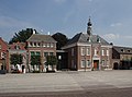 Town hall
 -
 Building in Gemert
 -
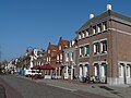 Street view
 -
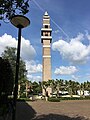 Tower of the St Gerardus Majella Church


References edit
- ^ a b c "Kerncijfers wijken en buurten 2021". Central Bureau of Statistics. Retrieved 16 April 2022.
- ^ "Postcodetool for 5421AA". Actueel Hoogtebestand Nederland (in Dutch). Het Waterschapshuis. Retrieved 16 April 2022.
- ^ Ad van der Meer and Onno Boonstra, Repertorium van Nederlandse gemeenten, KNAW, 2011.
- ^ Jos & Cor Swanenberg: Taal in stad en land: Oost-Brabants, ISBN 9012090105