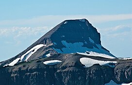
Fossil Mountain (10,921 feet (3,329 m)) is located in the Teton Range, within the Jedediah Smith Wilderness of Caribou-Targhee National Forest, U.S. state of Wyoming.[3]
| Fossil Mountain | |
|---|---|
 South aspect | |
| Highest point | |
| Elevation | 10,921 ft (3,329 m)[1] |
| Prominence | 756 ft (230 m)[1] |
| Coordinates | 43°39′13″N 110°55′08″W / 43.65361°N 110.91889°W[2] |
| Geography | |
| Parent range | Teton Range |
| Topo map | USGS Mount Bannon |
As mapped by J. D. Love and others, the peak of Fossil Mountain consists of relatively flat-lying beds of the Mississippian Madison Limestone and underlying Devonian Darby Formation.[4][5] Underlying the Darby Formation and exposed in shear clifts and floors of glacially modfied valleys are the Ordovician Bighorn Dolomite and Cambrian Gallatin Formation. In all, there is about 2,700 feet (820 m) of lower and middle Paleozoic sedimentary strata exposed within the area of Fossil Mountain.
The study of the sedimentary strata within the Teton Range, shows that these strata consist mostly of limestones and dolomites. The Madison Limestone consists of a basal, dark-colored, fine-grained dolomitic limestones overlain by hundreds of feet of gray limestone that is classified as fossiliferous oosparite and fossiliferous pelsparite.[6] Abundant fossils of shells and corals, which are protected by federal laws, have been found in the Madison Limestone at Fossil Mountain.[7] Underlying the Madison Limestone, the Darby Formation consists predominantly of dolomites and limestones that commonly contain discontinous layers of calcareous shale or sandstone.[6]
Fossil Mountain Ice Cave
editFossil Mountain Ice Cave is a notable solutional cave in the Madison Limestone west of Fossil Mountain. This cave is also known as Darby Ice Cave, Darby Canyon Caves, or Wind Cave. This cave has about 3 mi (4.8 km) of passage. The underground distance between entrances is about 1.5 mi (2.4 km) of travel underground 1 mi (1.6 km) on the surface. It is noted for the presence of layered ice and sediments depoists up to 42 ft (13 m) thick.[8][9][10]
Fossil Mountain Ice Cave has a combination of hazards that have resulted in frequent rescues. The safe exploration of this cave requires the participation of cavers with previous experience with this cave; expertise in ice and rock caving; specialized and appropriate caving equipment; and detailed planning and preparation, including the prepositioning of ropes, for a visit to this cave. Also, visiting this cave has detrimental effects on the preservation of scientifically significant ice deposits found within this cave. For example, visitor-induced melting of ice deposits was noted as early as 1975.[8][9][10]
The analysis of measurements of stable isotopes of oxygen and hydrogen recovered form samples of ice collected from Fossil Mountain Ice Cave provided a record of paleotemperatures of this part of the Teton Range for the past 175 years. They showed a continuing increase in local temperatures over the past the past 160 years. In addition, two consecutive very cold years in the early 1870s were found.[11]
References
edit- ^ a b "Fossil Mountain, Wyoming". Peakbagger.com. Retrieved 2011-09-18.
- ^ "Fossil Mountain". Geographic Names Information System. United States Geological Survey, United States Department of the Interior. Retrieved 2011-09-18.
- ^ Mount Bannon, WY (Map). TopoQwest (United States Geological Survey Maps). Retrieved 2011-09-18.
- ^ Reed, J.C. and Love, J.D., 1971, Preliminary geologic map of the Mount Bannon quadrangle, Teton County, Wyoming , Open-File Report OF-71-233, 1:24,000, one sheet. Reston, Virginia, U.S. Geological Survey.
- ^ Love, J.D., Reed Jr, J.C. and Christiansen, A.C., 1992. Geologic map of Grand Teton National Park, Teton County, Wyoming, Miscellaneous Investigations Series Map. I-2031, 1:62,500, one sheet. Reston, Virginia, U.S. Geological Survey.
- ^ a b Dixon, J.R. and Reeves, C.C., 1965. Representative carbonate petrography of some lower and middle Paleozoic rocks, west flank Teton Mountains, Wyoming. Journal of Sedimentary Research, 35(3), pp.704-72.
- ^ Schiess, B., 2014. Fossil Mountain and Caves of Darby Canyon, reporter1, Aug 28, 2014, Standard Journal, Madison County, Wyoming, last accessed August 20, 2024.
- ^ a b Higham, S.R., Palmer, A.N., 2018. Ice caves in the USA. In Persoiu, A., and Lauritzen, S.-E., eds., pp. 706-715. Ice Caves. Amsterdam, Netherlands, Elsevier. 730 pp. ISBN 978-0-631-20472-5
- ^ a b Hill, C., Sutherland, W., and Tierney, L., 1976, Caves of Wyoming. Bulletin 59. Geological Laramie, Wyoming, Geological Survey of Wyoming. 230 pp.
- ^ a b IWIC, 2014. International Workshop on Ice Caves 17-22 August 2014, Idaho Falls, Idaho. Craters of the Moon National Monument and Preserve Timpanogos Cave National Monument, Idaho, U.S. National Park Service. 24 pp.
- ^ Fuller, N., 2006, A reconstruction of Late Holocene climate in the Teton area from layers of sediment contained in ice from Fossil Mountain Ice Cave, Teton County, Wyoming. Alpine Karst, 2, pp. 1–14.
