
Size of this preview: 800 × 490 pixels. Other resolutions: 320 × 196 pixels | 640 × 392 pixels | 1,024 × 627 pixels | 1,590 × 973 pixels.
Original file (1,590 × 973 pixels, file size: 856 KB, MIME type: image/png)
| This is a file from the Wikimedia Commons. Information from its description page there is shown below. Commons is a freely licensed media file repository. You can help. |
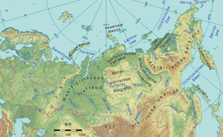
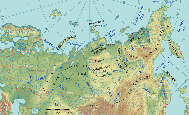
| Description | Physical map of almost all the Russian Federation emphasizing Siberia |
| Date | (UTC) |
| Source |
Image:Russland topo.png
|
| Author | Ulamm 21:06, 18 April 2008 (UTC) |
The map has been created with the Generic Mapping Tools: https://www.generic-mapping-tools.org/ using one or more of these public-domain datasets for the relief:
|

|
Permission is granted to copy, distribute and/or modify this document under the terms of the GNU Free Documentation License, Version 1.2 or any later version published by the Free Software Foundation; with no Invariant Sections, no Front-Cover Texts, and no Back-Cover Texts. A copy of the license is included in the section entitled GNU Free Documentation License. |
| This file is licensed under the Creative Commons Attribution-Share Alike 3.0 Unported license. | ||
| ||
| This licensing tag was added to this file as part of the GFDL licensing update. |
File history
Click on a date/time to view the file as it appeared at that time.
| Date/Time | Thumbnail | Dimensions | User | Comment | |
|---|---|---|---|---|---|
| current | 10:57, 28 September 2016 | | 1,590 × 973 (856 KB) | AlexTref871 | Add Nizhny Novgorod |
| 18:40, 29 August 2012 |  | 1,590 × 973 (875 KB) | Ulamm | {{Information |Description ={{de|1=Physical map of almost all the Russian Federation emphasizing Siberia, "Leptew-See" korrigiert zu "Laptew-See"}} |Source =File:Russland topo.png |Author =~~~~ |Date =21:06, 18 April 2008 (... | |
| 17:37, 20 April 2008 |  | 1,590 × 973 (875 KB) | Ulamm | ||
| 23:48, 18 April 2008 |  | 1,590 × 973 (872 KB) | Ulamm | ||
| 21:06, 18 April 2008 |  | 1,590 × 973 (1.14 MB) | Ulamm | {{Information |Description=Physical map of allmost all the Russian Federation emphasizing Siberia |Source=Image:Russland topo.png |Date= |Author=~~~~ |Permission= |other_versions= |Information=The map has been created with the Generic Mapping Tools: |
File usage
The following pages on the English Wikipedia use this file (pages on other projects are not listed):
Global file usage
The following other wikis use this file:
- Usage on als.wikipedia.org
- Usage on cs.wikipedia.org
- Usage on da.wikipedia.org
- Usage on de.wikipedia.org
- Usage on dsb.wikipedia.org
- Usage on es.wikipedia.org
- Usage on fa.wikipedia.org
- Usage on fr.wikipedia.org
- Usage on he.wikipedia.org
- Usage on lb.wikipedia.org
- Usage on mk.wikipedia.org
- Usage on nl.wikipedia.org
- Usage on no.wikipedia.org
- Usage on pfl.wikipedia.org
- Usage on pl.wiktionary.org
- Usage on ro.wikipedia.org
- Usage on sl.wikipedia.org
- Usage on sv.wikipedia.org
- Usage on tr.wikipedia.org
View more global usage of this file.