File:REAR - Georgetown University, Old North Building, Thirty-Seventh and O Streets Northwest, Washington, District of Columbia, DC HABS DC,GEO,20A-5.tif

Size of this JPG preview of this TIF file: 453 × 599 pixels. Other resolutions: 181 × 240 pixels | 363 × 480 pixels | 581 × 768 pixels | 774 × 1,024 pixels | 1,549 × 2,048 pixels | 3,776 × 4,993 pixels.
Original file (3,776 × 4,993 pixels, file size: 17.98 MB, MIME type: image/tiff)
| This is a file from the Wikimedia Commons. Information from its description page there is shown below. Commons is a freely licensed media file repository. You can help. |
Summary
| REAR - Georgetown University, Old North Building, Thirty-Seventh and O Streets Northwest, Washington, District of Columbia, DC | ||||
|---|---|---|---|---|
| Title |
REAR - Georgetown University, Old North Building, Thirty-Seventh and O Streets Northwest, Washington, District of Columbia, DC |
|||
| Depicted place | District of Columbia; District of Columbia; Washington | |||
| Date | Documentation compiled after 1933 | |||
| Dimensions | 4 x 5 in. | |||
| Current location |
Library of Congress Prints and Photographs Division Washington, D.C. 20540 USA http://hdl.loc.gov/loc.pnp/pp.print |
|||
| Accession number |
HABS DC,GEO,20A-5 |
|||
| Credit line |
|
|||
| Notes |
|
|||
| Source | https://www.loc.gov/pictures/item/dc0239.photos.025576p | |||
| Permission (Reusing this file) |
|
|||

| Camera location | | View this and other nearby images on: OpenStreetMap |
|---|
File history
Click on a date/time to view the file as it appeared at that time.
| Date/Time | Thumbnail | Dimensions | User | Comment | |
|---|---|---|---|---|---|
| current | 03:57, 9 July 2014 | 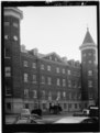 | 3,776 × 4,993 (17.98 MB) | Fæ | GWToolset: Creating mediafile for Fæ. HABS 08 July 2014 (701:800) |
File usage
The following pages on the English Wikipedia use this file (pages on other projects are not listed):