
Size of this PNG preview of this SVG file: 402 × 599 pixels. Other resolutions: 161 × 240 pixels | 322 × 480 pixels | 515 × 768 pixels | 687 × 1,024 pixels | 1,374 × 2,048 pixels | 730 × 1,088 pixels.
Original file (SVG file, nominally 730 × 1,088 pixels, file size: 1.06 MB)
| This is a file from the Wikimedia Commons. Information from its description page there is shown below. Commons is a freely licensed media file repository. You can help. |

Summary
| Description |
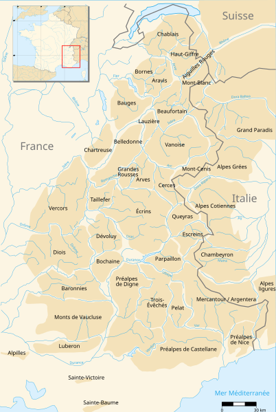
Français : Carte représentant les massifs des Alpes occidentales. English: Map of the French Alps. Deutsch: Karte der französischen Alpen. Italiano: Mappa delle Alpi francesi. |
| Date | |
| Source |
This W3C-unspecified vector image was created with Inkscape .
|
| Author | Pinpin & ҉ Cerveaugenie |
| Other versions |
Derivative works of this file: Massifs des Préalpes map-fr.svg
|


|
This SVG file contains embedded text that can be translated into your language, using any capable SVG editor, text editor or the SVG Translate tool. For more information see: About translating SVG files. |
Licensing
I, the copyright holder of this work, hereby publish it under the following licenses:

|
Permission is granted to copy, distribute and/or modify this document under the terms of the GNU Free Documentation License, Version 1.2 or any later version published by the Free Software Foundation; with no Invariant Sections, no Front-Cover Texts, and no Back-Cover Texts. A copy of the license is included in the section entitled GNU Free Documentation License. |
This file is licensed under the Creative Commons Attribution-Share Alike 3.0 Unported, 2.5 Generic, 2.0 Generic and 1.0 Generic license.
- You are free:
- to share – to copy, distribute and transmit the work
- to remix – to adapt the work
- Under the following conditions:
- attribution – You must give appropriate credit, provide a link to the license, and indicate if changes were made. You may do so in any reasonable manner, but not in any way that suggests the licensor endorses you or your use.
- share alike – If you remix, transform, or build upon the material, you must distribute your contributions under the same or compatible license as the original.
You may select the license of your choice.
File history
Click on a date/time to view the file as it appeared at that time.
| Date/Time | Thumbnail | Dimensions | User | Comment | |
|---|---|---|---|---|---|
| current | 18:36, 13 January 2015 | | 730 × 1,088 (1.06 MB) | Gemini1980 | svg properties |
| 00:17, 28 August 2014 |  | 744 × 1,052 (450 KB) | Gemini1980 | centering | |
| 00:09, 28 August 2014 |  | 744 × 1,052 (450 KB) | Gemini1980 | some corrections | |
| 13:38, 6 May 2008 |  | 730 × 1,088 (986 KB) | Cerveaugenie | Ajout d'une légende (approximative) | |
| 10:41, 5 May 2008 |  | 1,032 × 1,537 (1.15 MB) | Cerveaugenie | {{fr|A la demande de Gemini1980, remplacement de Arvan-Villards par Arves}} | |
| 00:46, 31 October 2007 |  | 1,032 × 1,537 (1.15 MB) | Sting | Some corrections | |
| 19:19, 30 September 2007 |  | 1,032 × 1,537 (1.15 MB) | Pinpin | oups problème de cadrage | |
| 19:16, 30 September 2007 |  | 744 × 1,052 (1.15 MB) | Pinpin | {{Information |Description={{fr}} Carte représentant les massifs des Alpes françaises. |Source=own work made with inkscape from original Image Image:Massifs des Alpes.png and Image:France blank.svg |Date=2007-09-30 |Author= [[User:Pinpin|Pinpi |
File usage
The following pages on the English Wikipedia use this file (pages on other projects are not listed):
Global file usage
The following other wikis use this file:
- Usage on ba.wikipedia.org
- Usage on ca.wikipedia.org
- Usage on cy.wikipedia.org
- Usage on de.wikipedia.org
- Usage on el.wikipedia.org
- Usage on eo.wikipedia.org
- Usage on es.wikipedia.org
- Usage on fr.wikipedia.org
- Le Caire (Alpes-de-Haute-Provence)
- Utilisateur:Korrigan/Aide-mémoire
- Sigonce
- Montfuron
- Saint-Michel-l'Observatoire
- Pierrerue (Alpes-de-Haute-Provence)
- Niozelles
- Aubignosc
- Authon (Alpes-de-Haute-Provence)
- Bayons
- Bellaffaire
- Châteaufort (Alpes-de-Haute-Provence)
- Châteauneuf-Val-Saint-Donat
- Clamensane
- Claret (Alpes-de-Haute-Provence)
- Cruis
- L'Escale (Alpes-de-Haute-Provence)
- Fontienne
- Ganagobie
- Gigors
- Limans
- Lurs
- Mallefougasse-Augès
- Melve
- Mison
- Montfort (Alpes-de-Haute-Provence)
- Montlaux
- La Motte-du-Caire
- Nibles
- Ongles
View more global usage of this file.