
Size of this JPG preview of this TIF file: 800 × 600 pixels. Other resolutions: 320 × 240 pixels | 640 × 480 pixels | 1,024 × 768 pixels | 1,280 × 960 pixels | 2,560 × 1,920 pixels.
Original file (2,560 × 1,920 pixels, file size: 11.17 MB, MIME type: image/tiff)
| This is a file from the Wikimedia Commons. Information from its description page there is shown below. Commons is a freely licensed media file repository. You can help. |
Summary
| Description |
Afrikaans: Hewige ontbossing was tydens die 20ste eeu die norm op die eiland Hispaniola. Die verskynsel het albei nasies op die eiland geraak, maar dit het sy mees kritieke vlak in die Republiek van Haïti bereik. Die probleem het so akuut geword dat Haïtiaanse woudbedekking slegs 2% is, vergeleke met 40% in die Dominikaanse Republiek. Hierdie kontras word duidelik aan die Haïtiaans-Dominikaanse grens gesien, sodat ruimtevaarders die politieke grens tussen hierdie twee lande kan identifiseer net deur waar te neem waar die bosbedekking skielik eindig. Op beeld is die Republiek van Haïti aan die linkerkant en die Dominikaanse Republiek aan die regterkant.
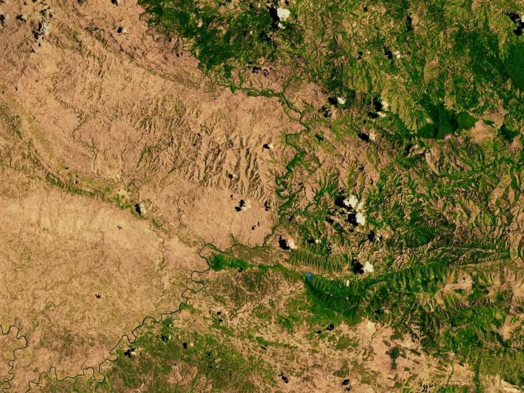
English: The island of Hispaniola has been subject to heavy deforestation during the 20th century. This phenomenon has affected both nations that occupy the island, however it has reached its most critical level in the Republic of Haiti. The problem has become so acute that Haitian forest cover is only 2% compared to 40% in the Dominican Republic. This contrast is clearly seen in the Haitian-Dominican border, such that astronauts can identify the political border between these two countries just by observing where the forest cover ends abruptly. The Republic of Haiti is on the left and the Dominican Republic is on the right.
Español: La Isla de Santo Domingo ha sido sujeta una fuerte deforestación durante el siglo XX. Este fenómeno ha afectado a ambas naciones que ocupan la isla, sin embargo ha llegado a su nivel más crítico en la República de Haití. El problema se ha agudizado tanto, que la cubierta forestal haitiana es de tan solo 2% comparado con el 40% en República Dominicana. Este constraste se nota claramente en la frontera domínico-haitiana con lujos de detalles, que los astronautas pueden identificar la frontera política entre estos dos países con tan solo observar dónde la cobertura boscosa termina abruptamente. La República de Haití en la izquierda y la República Dominicana en la derecha. |
| Date | |
| Source | https://svs.gsfc.nasa.gov/vis/a000000/a002600/a002640/ |
| Author | NASA |
Licensing
| This file is in the public domain in the United States because it was solely created by NASA. NASA copyright policy states that "NASA material is not protected by copyright unless noted". (See Template:PD-USGov, NASA copyright policy page or JPL Image Use Policy.) | ||
 |
Warnings:
|
File history
Click on a date/time to view the file as it appeared at that time.
| Date/Time | Thumbnail | Dimensions | User | Comment | |
|---|---|---|---|---|---|
| current | 03:02, 10 February 2014 |  | 2,560 × 1,920 (11.17 MB) | Siso84~commonswiki | User created page with UploadWizard |
File usage
The following pages on the English Wikipedia use this file (pages on other projects are not listed):
Global file usage
The following other wikis use this file:
- Usage on eo.wikipedia.org
- Usage on fr.wikipedia.org
- Usage on ja.wikipedia.org